Sold2021Boating maps, western New Providence, rose island,Maps from 1981 tropic Isle publishers, Inc By Harry Kline, Western New Providence, rose Island, eastern approaches to Nassau harbour. Size 11“ x 17“See Sold Price
Sold2021Boating maps, Nassau Harbour, New Providence Island,Maps from 1981 tropic Isle publishers, Inc By Harry Kline, Nassau Harbour, new Providence Island, Little Harbor and alder cay anchorages. Size 11“ x 17“See Sold Price
Sold2018West Indies the Bahama Islands Exuma to New ProvidenceTitle/Content of Map: West Indies the Bahama Islands Exuma to New Providence Date Printed: 01/07/1975 Cartographer: HYDROGRAPHIC OFFICE. ROYAL NAVY Size (inches): 38X25 Detailed nautical chart. CopiouSee Sold Price
Sold20211721 Map of America With California as an IslandHistoric Maps 1721 Hand-Colored "A New Map of America from the Latest Observations" with "California" Shown as an Island 1721 Hand-Colored Engraved Western Hemisphere Map titled, "A New Map of AmericaSee Sold Price
Sold2023Map: United States– East Coast / Connecticut– New York/ Long Island Western PartDescription: United States– East Coast / Connecticut– New York/ Long Island Western Part. Published at Washington D.C. US Department of Commerce, National Oceanic Service. Measurement apSee Sold Price
Sold2022Munson's A New Map of the Western Rivers, 1846MUNSON, Sam[ue]l B[ishop] (1806-1880). A New Map of the Western Rivers. Or Travellers Guide Exhibiting the Mississippi, Missouri, Ohio, and Illinois Rivers, with all the Principal Towns, Islands & DisSee Sold Price
Sold2019Four Pieces of American Silver Deposit GlasswareFour Pieces of American Silver Deposit Colored Glassware first quarter 20th century, Providence, Rhode Island, including: Gorham Model D1135, a R. L. Rose & Co. brown glass cylindrical bourbon bottleSee Sold Price
Sold2022Tourist Pamphlets and Map Group [154561]About 35 tourist related ephemera items. Maps, tourist pamphlets-Vancouver Island, Seattle, Monticello, Portland, Stockholm. Death Valley, New Mexico, Zion, Bryce, Berlin, neat NYC vintage photo book,See Sold Price
Sold20201699 D’Eilanden van Capo Verde, de Kust en’t Landt derThis attractive antique hand-colored map features the Cape Verde Islands off the west coast of Africa, and a portion of the coast of western Africa including Muritaniya, Cape Verde, Gambia, and SenegaSee Sold Price
Sold2017Fantastic Dutch 17th C. map of Japan & adjacent islandsA nice Dutch map of Japan and adjacent islands by Joan Jansson, c. 1660. Title: New and Accurate Japan, Land of Ezo and Adjacent Islands, fully hand-colored with 2 Compass Roses, 4 Galleons and a SeaSee Sold Price
Sold2021Boating Maps, Long Island, Long Island north end, eastMaps from 1981 tropic Isle publishers, Inc. by Harry Klein, Long Island, Long Island Northwynn, East Coast harbors. Size, 11” x17”See Sold Price
Sold2021Boating maps, crooked island district, little SanMaps from 1981 tropic Isle publishers, Inc By Harry Kline, Crooked island district, little San Salvador little island or little cat island, cat island and little San Salvador. Size 11“ x 17̶See Sold Price
Sold2021Boating maps, royal island harbor, egg islands, currentMaps from 1981 tropic Isle publishers, Inc By Harry Kline, Royal island harbor, egg Islands, current island Anchorage. Size 11“ x 17“See Sold Price
Sold2019Bahamian Governor William Shirley Writes of EspionageShirley William Manuscript Document Signed "W Shirley" as Governor of the Bahamas, 2 pages, 9" x 14.25", front and verso. New Providence, Bahama Islands, August 27, 1762. Also signed by the author ofSee Sold Price
Sold2021Boating maps, Southern Berry islands, Central BerryMaps from 1981 tropic Isle publishers, Inc By Harry Kline, Southern Berry Islands, Central Berry islands, Northern Berry islands. Size 11“ x 17“See Sold Price
Sold2017Bellin: Antique Map of New Zembla Island, 1750Title/Content of Map: Island of New Zembla Northern Russia Arctic Ocean Date Printed: 1750's -60's Cartographer: Jacques Nicolas Bellin Material/Medium: Paper Size: 9 1/2" x 7" Copperplate engraving.See Sold Price
Sold2022VARIOUS ARTISTS. [ILLUSTRATED MAPS]. Group of 3 posters. 1930s-1940s. Sizes vary.VARIOUS ARTISTS [ILLUSTRATED MAPS]. Group of 3 posters. 1930s-1940s. Sizes vary. Condition varies, generally A- / A. Group includes: A Map of Western Long Island (1939), by Rolf Klep; Michigan / UpperSee Sold Price
Sold2022William B. Durgin Co. Bug cold meat forkWilliam B. Durgin Co. Bug cold meat fork with insect and snake motif Concord, New Hampshire & Providence, Rhode Island, circa 1885 sterling silver stamped marks engraved M monogram 1 5/16"w x 8 5/8"lSee Sold Price
Sold2022William B. Durgin Co. Bug sauce or gravy ladleWilliam B. Durgin Co., retailed by Hugo Beil of Boston Bug sauce or gravy ladle insect and snake motif Concord, New Hampshire & Providence, Rhode Island, circa 1885 sterling silver parcel-gilt stampedSee Sold Price
Sold2018A Pair of Wm. B. Durgin Co. Silver Candlesticks,A Pair of Wm. B. Durgin Co. Silver Candlesticks, Concord, New Hampshire & Providence, RhodSee Sold Price
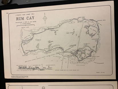
Sold2021Boating maps, rum cay, conception island, San Salvador.Maps from 1981 tropic Isle publishers, Inc By Harry Kline, Rum Cay, Conception island, San Salvador. Size 11“ x 17“See Sold Price
Sold2021Boating maps, harbors creeks cat Island, Turks andMaps from 1981 tropic Isle publishers, Inc By Harry Kline, Harbors creeks cat Island, Turks end Caicos Islands. 11“ x 17“See Sold Price
Sold2019Bryce, James 1881 Map of New Zealand South IslandLithograph Map Published 1881, London for ""The International Atlas and Geography..." by James Bryce. Maps by Edward Weller & John Bartholomew. Uncommon. Paper Size: 18 x 13 inch (46 x 33cm) Good CondSee Sold Price
Sold2019Bryce, James 1881 Map of New Zealand North IslandLithograph Map Published 1881, London for ""The International Atlas and Geography..." by James Bryce. Maps by Edward Weller & John Bartholomew. Uncommon. Paper Size: 18 x 13 inch (46 x 33cm) Good CondSee Sold Price
2 days LeftJasper52BRITISH WESTERN PACIFIC ISLANDS FLAGS. New Hebrides. Solomon Islands. Papua 1916$8
2 days LeftJasper52Hawaiian–Emperor seamount chain Midway-Kauai ADMIRALTY chart 1950 (1955) map$140(1 bid)
2 days LeftJasper52Isles de la Reine Charlotte. Nendo, Santa Cruz, Solomon Islands. BONNE 1788 map$20
2 days LeftJasper52Isles de la Reine Charlotte. Nendo, Santa Cruz, Solomon Islands. BONNE 1790 map$20
18 hrs LeftJasper52Bay Ridge, Red Hook and Buttermilk Channels. Gowanus Creek Channel. Channel Between the Battery and$75
18 hrs LeftJasper521863 Johnson Map of Massachusetts, Connecticut and Rhode Island -- Johnson's Massachusetts,$50
Jun 27Rail & Road AuctionsGroup of Ninety Post Cereal Railroad Tins - Rock Island, Reading, Great Northern, Wabash, Milwaukee$30(1 bid)
2 days LeftJasper52Pacific Islands. Dusky Sound. Wallis Tonga Cook Easter Pitcairn. BONNE 1788 map$45
18 hrs LeftJasper52Map Showing the Line of the Brooklyn Water-Works, 1871 | Section of Long Island from North to South.$45
Featured18 hrs LeftJasper521863 Johnson's New Brunswick, Nova Scotia, Newfoundland, and Prince Edward Island$40
2 days LeftJasper52Nouvelle Caledonie. Baies de Kuakue et de Uinne'. CHAMBEYRON sea chart 1891 map$100


![Munson's A New Map of the Western Rivers, 1846: MUNSON, Sam[ue]l B[ishop] (1806-1880). A New Map of the Western Rivers. Or Travellers Guide Exhibiting the Mississippi, Missouri, Ohio, and Illinois Rivers, with all the Principal Towns, Islands & Dis](https://p1.liveauctioneers.com/1968/250616/130196575_1_x.jpg?height=310&quality=70&version=1654190895)

![Tourist Pamphlets and Map Group [154561]: About 35 tourist related ephemera items. Maps, tourist pamphlets-Vancouver Island, Seattle, Monticello, Portland, Stockholm. Death Valley, New Mexico, Zion, Bryce, Berlin, neat NYC vintage photo book,](https://p1.liveauctioneers.com/2699/258185/134287879_1_x.jpg?height=310&quality=70&version=1660347389)


![VARIOUS ARTISTS. [ILLUSTRATED MAPS]. Group of 3 posters. 1930s-1940s. Sizes vary.: VARIOUS ARTISTS [ILLUSTRATED MAPS]. Group of 3 posters. 1930s-1940s. Sizes vary. Condition varies, generally A- / A. Group includes: A Map of Western Long Island (1939), by Rolf Klep; Michigan / Upper](https://p1.liveauctioneers.com/199/255737/132982810_1_x.jpg?height=310&quality=70&version=1658424802)


![[Americana] Articles of Confederation and Perpetual Union... (1 of 1)](https://p1.liveauctioneers.com/65/332523/179334997_1_x.jpg?height=282&quality=70&version=1717622830)


![1863 Johnson's Lower Canada and New Brunswick [on sheet with] Upper Canada (1 of 1)](https://p1.liveauctioneers.com/5584/332709/179478760_1_x.jpg?height=282&quality=70&version=1718142738)


