Sold20221656 Jansson Map of Paris Environs -- Ager Parisiensis Vulgo L'Isle de FranceTitle: 1656 Jansson Map of Paris Environs -- Ager Parisiensis Vulgo L'Isle de France Cartographer: J Jansson Year / Place: 1656 ca., Amsterdam Map Dimension (in.): 12.9 X 18.2 in This is an excellentSee Sold Price
Sold2022EUROPE. INDUSTRIES. Coal & Iron deposits. British consuls. Railways 1920 mapTITLE/CONTENT OF MAP: 'Central & Western Europe (Industrial)' DATE PRINTED: 1920 IMAGE SIZE: Approx 34.0 x 45.0cm, 13.25 x 17.5 inches (Large) TYPE: Vintage colour map CONDITION: Good; suitable for frSee Sold Price
Sold2018EUROPE. INDUSTRIES. Coal & Iron deposits. BritishTITLE/CONTENT OF MAP: 'Central & Western Europe (Industrial)' DATE: 1920 IMAGE SIZE: Approx 34.0 x 45.0cm, 13.25 x 17.5 inches (Large) TYPE: Vintage colour map CONDITION: Good; suitable for framing. HSee Sold Price
Sold20211602 Ortelius Map of Western France Including CognacTitle: 1602 Ortelius Map of Western France Including Cognac and Limoges -- Poictou Cartographer: A Ortelius Year / Place: 1602, Antwerp Map Dimension (in.): 3 X 4.2 in. This is an attractive map of weSee Sold Price
Sold20211602 Ortelius Map of Central France -- LimaniaTitle: 1602 Ortelius Map of Central France -- Limania Cartographer: A Ortelius Year / Place: 1602, Antwerp Map Dimension (in.): 3 X 4.1 in. This is a delightful smaller map of central France's AllierSee Sold Price
Sold2022French Le Maine hand colored map engraving, central France, by Nicolas Sanson (1600-1667) 15"H xFrench Le Maine hand colored map engraving, central France, by Nicolas Sanson (1600-1667) 15"H x 19"W (image), 23"H x 30 3/4"W (frame)See Sold Price
Sold20211602 Ortelius Map of Central France -- BiturigiumTitle: 1602 Ortelius Map of Central France -- Biturigium Cartographer: A Ortelius Year / Place: 1602, Antwerp Map Dimension (in.): 3 X 4.2 in. This is a smaller map of central France with Bourges at tSee Sold Price
Sold2019Desnos 1765 Antique Map of Central France"Feuille Qui donne les Routes et Chemins, tant Royaux que Particuliers, compris entre les deux grandes Routes de Paris" Copper Engraved Map Published 1765, Paris for "Coup d'oeil general sur la FranceSee Sold Price
Sold2020Jan Jansson Colored Map of Central & South AmericaJan Jansson (Johannes Janssonius; Dutch, 1588-1664). Framed antique etching print of South and Central America. Titled TERRA FIRMA ET NOVUM REGNUM GRANATENSE ET POPAYAN. Hand colored. Unknown printingSee Sold Price
Sold2016Jansson map of Valois, FranceHeading: Author: Jansson, Jan Title: Valesium Ducatus - Valois Place Published: Amsterdam Publisher: Date Published: c.1640 Description: Copper-engraved map, hand-colored.See Sold Price
Sold20221640 Jansson Map of Northern France Centered on Lille -- Flandria Gallica Continens CastellaniasTitle: 1640 Jansson Map of Northern France Centered on Lille -- Flandria Gallica Continens Castellanias Cartographer: J. Jansson Year / Place: 1640 c., Amstedam Map Dimension (in.): 15.6x19.6 in. ThisSee Sold Price
Sold2019MAP - Western Mexico. MercatorWestern Mexico. Mercator/Hondius, Hispania Nova, 1613 (published). Hand Color. Lovely small map of central and western Mexico. It locates many cities and features including Mexico City on the shore ofSee Sold Price
Sold2018Cornell: Antique Map of West, Central & South EuropeTitle/Content of Map: Western, Central & Southern Continental Europe. Date Printed: 1857 Cartographer: CORNELL, SARAH SOPHIA Publisher: D. APPLETON 1857 NEW YORK Size: Folio – 12.60 H x 20.30 W InchSee Sold Price
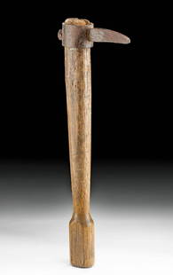
Sold2021WWI European Wood Trench Club w/ Iron SpikeWestern/Central Europe, France or Germany, World War I era, ca. 1914 to 1918 CE. A deadly weapon with a wooden handle and an iron spike surmounted on the tip. This club resembles a medieval style of wSee Sold Price
Sold2018Mexico.- Ortelius (Abraham) Hispaniae Novae SivaeMexico.- Ortelius (Abraham) Hispaniae Novae Sivae Magnae, Recens et Vera Descriptio, map of the central and western coastal regions of Mexico, with three ornate strap-work cartouche, engraving with eaSee Sold Price
Sold2022Mexico.- Ortelius (Abraham) Hispaniae Novae Sivae Magnae, Recens et Vera Descriptio, engraved map,Mexico.- Ortelius (Abraham) Hispaniae Novae Sivae Magnae, Recens et Vera Descriptio, map of the central and western coastal regions of Mexico, with three ornate strap-work cartouche, engraving with haSee Sold Price
Sold2022c.1859 Map: Dept. De La Charente, by Levasseur.Handsomely framed hand-colored c1859 engraving of the department of Charente in western France, the map surrounded by elaborate vignettes illustrating personages and products for which the region wasSee Sold Price
Sold2020Original WWII U.S. Army Silk Evasion MapsOriginal WWII U.S. Army Silk Evasion Maps - Offered Without Reserve - There is NO ESTIMATE on this item. - Vintage Original WWII U.S. Army Silk Evasion Maps for Aviators Depicting Central FranceSee Sold Price
Sold2024Jacques Nicolas Bellin Map Of Western Part Of New France Or CanadaPartie Occidentale de la Nouvelle France, by Mr. Jacques Nicolas Bellin, Marine Engineer, summarizes the knowledge of the region as the French knew it prior to the British invasionSee Sold Price
Sold20201730 Homann Map of Western Belgium and Northern FranceTitle/Content of Map: 1730 Homann Map of Western Belgium and Northern France -- Comitatus Flandriae in omnes ejusdem subjacentes Ditioes Cartographer: J Homann Year/Place: 1730 c., Nurnberg Size: 19 XSee Sold Price
Sold2023Carel Allard, Map the Sevennes Region in South Central FranceCarel Allard, Map the Sevennes Region in South Central FranceAmsterdam, early 18th century, copperplate engraving with outline color; focusing of the Diocese of Monpellier; matted and framed under glaSee Sold Price
Sold2023Map of Western and Central Mexico. C1611 by Jodocus HondiusTitle: Map of Western and Central Mexico. C1611 by Jodocus Hondius Date/Period: c1611 Materials: Copperplate engraved, hand colored Size: 19 x 14” Antique map of Western and Central Mexico, creaSee Sold Price
Sold20201710 Chatelain Map of Western and Central Africa --Title: 1710 Chatelain Map of Western and Central Africa -- Carte de la Barbarie, Nigritie et de la Guinee avec les Pays Voisins, Dressee sur les Memoires les Plus Nouveaux & les Observations les PlusSee Sold Price
Sold2023Antique Hand Colored Map of the Western Part of CanadaAntique Hand Colored Map of the Western Part of CanadaNice hand colored engraved on paper an antique, 1755 map of the western part of New France or Canada by M. Bellin, Engineer of the king. FeaturingSee Sold Price
Jul 06Case Antiques, Inc. Auctions & AppraisalsColton's Atlas of the World, 1856, in Two Volumes; plus Africa / Mahdist War Map$500(1 bid)
Jun 28Rail & Road AuctionsGroup of Fourteen Railroad Stock Certificates - Illinois Central, Denver & Rio Grande Western,$40(2 bids)
5 days LeftDOYLE Auctioneers & AppraisersAn eighteenth-century map of Nîmes in Southern France, with views of its Roman monuments$100
Freeman's | Hindman[MAPS]. A group of 8, incl. 5 maps of North America, one of the western hemisphere, & 2 engravings.$150
1 day LeftTrillium Antique Prints & Rare BooksCatesby, Folio - Summer Redbird with Western Planetree. 1-56$200(1 bid)
4 days LeftJasper521575 Braun and Hogenberg View of Aalst in Belgium -- Aelst. - Alostum, Urbs Flandriae Imperatoriae$200
2 days LeftEast Coast Fine Arts LLC1777 US Revolutionary War Map French Brion de la Tour Theatre de Guerre$1,000
2 days LeftLeonard Auction, a division of The Leonard CompanyEuropean and United States Map Assortment$150
Jun 28Rail & Road AuctionsDiverse Group of Railroad Paper and Photos - Early 1900s N&W Telegrams, W&LE Photos and Yard Maps,$30
BonhamsPEARY'S COPY OF AN EARLY NORTH AMERICAN MAP. PEARY, ROBERT E. 1856-1920.] DOBBS, ARTHUR. 1689-17...$100(1 bid)


![[MAPS]. A group of 8, incl. 5 maps of North America, one of the western hemisphere, & 2 engravings. (1 of 0)](https://p1.liveauctioneers.com/dist/images/placeholder.jpg?height=282&quality=70)


![[Literature] Haggard, H. Rider: King Solomon's Mines (1 of 2)](https://p1.liveauctioneers.com/65/332523/179335141_1_x.jpg?height=282&quality=70&version=1717622830)


![PEARY'S COPY OF AN EARLY NORTH AMERICAN MAP. PEARY, ROBERT E. 1856-1920.] DOBBS, ARTHUR. 1689-17... (1 of 3)](https://p1.liveauctioneers.com/1043/333441/180036747_1_x.jpg?height=282&quality=70&version=1718642562)