Sold2021RR map of South Carolina, 1853Nice railroad map of South Carolina with railroad lines highlighted in red overlay hand color to make them stand out (done at the time it was published in 1853). Shows counties, towns, rivers, lakes,See Sold Price
Sold2022Scarce early Cram RR map of Southern states“New Railroad and County Map of Alabama, Georgia, South Carolina and North Carolina” from the extremely scarce 1882 edition of Cram’s Unrivaled Family Atlas of the World. This was tSee Sold Price
Sold20211887 US Southern States RR MapTitle: 1887 US Southern States RR Map Author: Watson Materials: Ink on Paper Dimensions: 21"X14" Description: Rail road map of the US Southern States-Alabama, Geogia, South Carolina and Northern FloriSee Sold Price
Sold20171853 Hand Drawn Map Sumter District South Carolinadrawn on what appears to be a handkerchief or piece of linen by Samuel N. Atkinson surveyor, at the request of M.E. Dixon. map depicts 751 acres and includes borders with Middleton Plantation and theSee Sold Price
Sold2021Soil Map. South Carolina Darlington SheetPublication Date: 1902 Title: Soil Map. South Carolina Darlington Sheet Cartographer: RICE, T. D. / F. W. TAYLOR Publisher: U.S. DEPARTMENT OF AGRICULTURE. (BUREAU OF SOILS) Height: 30.6 Width: 34 ColSee Sold Price
Sold2017Colton: Antique Pre Civil War Map South Carolina, 1861Title/Content of Map: Pre Civil War South Carolina by Colton Date Printed: 1861 Cartographer: J.H. Colton Material/Medium: Paper Size: 17 1/2" x 14" Hand colored steel engraved Map from 'Colton's GeneSee Sold Price
Sold[CIVIL WAR, CURRENCY]. Group of Confederate CurrencyGroup of 14 antebellum Southern and Confederate currency notes. 5 antebellum notes, including: Planters Bank of Fairfield $10 note. Winnsboro, South Carolina, 1853. -- The Bank of East Tennessee $2 noSee Sold Price
Sold2019OBSOLETE CURRENCY LOTSTATE OF SOUTH CAROLINA 1872 $10.00, PLANTERS BANK OF FAIRFIELD SOUTH CAROLINA 1853 $10.00, AND FARMERS AND EXCHANGE BANK CHARLESTOWN 1853 $10.00See Sold Price
Sold2018South Carolina by ColtonTitle/Content of Map: South Carolina by Colton Date: 1871 Cartographer: G.W. Colton Material/Medium: Paper Size: 14" x 17" Provenance: New York Hand colored lithograph. Published in New York in 'ColtoSee Sold Price
Sold2018Tanner: Antique Map of South Carolina, 1843Title/Content of Map: South Carolina by Tanner Date Printed: 1843 Cartographer: H.C. Tanner Material/Medium: Paper Size: 17" x 14" Hand colored engraved Map based on the work of H.C. Tanner from the fSee Sold Price
Sold2018South Carolina by BradfordTitle/Content of Map: South Carolina by Bradford Date Printed: 1838/41 Cartographer: Thomas G. Bradford Material/Medium: Paper Size: 14" x 16" Provenance: New York A General Atlas of the World with aSee Sold Price
Sold2018Colton: Antique Map of South Carolina, 1871Title/Content of Map: South Carolina by Colton Date Printed: 1871 Cartographer: G.W. Colton Material/Medium: Paper Size: 17" x 14" Hand colored lithograph. From 'Colton's American Atlas'. Published inSee Sold Price
Sold2023Emanuel Bowen Map North & South Carolina, Georgia[Emanuel Bowen Map of North & South Carolina and Georgia] , "A New & Accurate Map of the Provinces of North & South Carolina Georgia & c. Drawn from late Surveys and regulated by Astron Observat. By ESee Sold Price
Sold2023Extremely scarce map of South Carolina (1814)Scarce third state of Samuel Lewis’s map of South Carolina, appearing in the extremely scarce 1816 edition of Carey’s General Atlas (same map as in the 1814 Carey atlas). One of the earlieSee Sold Price
Sold20211779 NEW AND ACCURATE MAP OF SOUTH CAROLINAA New And Accurate Map Of The Province Of South Carolina In North America. London: Universal Magazine, c. 1779. Good, showing folds, 2 small tears to edges. Narrow margins. The map shows trails and paSee Sold Price
Sold2018Tanner / Reid Map of South Carolina, 1796Tanner, Benjamin (1775-1848). State of South Carolina from the Best Authorities. Engraved map. J. Reid, 1796. 15" x 17" sheet. Published by John Reid New York. A very early and scarce folio map of SouSee Sold Price
Sold20192 Hand Colored Maps - Georgia & South CarolinaTwo Gray's Atlas Maps on one sheet - Georgia and South Carolina Inset of Charleston on South Carolina map. Depicts railroad lines, common roads, canals, topography,See Sold Price
Sold20191807 Map Charleston, South CarolinaPublished Philadelphia by C.P. Wayne. The piece titled ÒPlan of the Siege of Charleston in S. CarolinaÓ. Sight size: H10" W15" (without frame)See Sold Price
Sold202119th c. NEW MAP OF SOUTH CAROLINARare 19th c. A New Map of South Carolina with its Canals, Roads & Distances from place to place along the Stage & Steam Boat Routes. By H.S. Tanner c. 1841-1845. Fine example of Tanner's map of SouthSee Sold Price
Sold2017Meyer: Antique Map of South Carolina & Charleston, 1852Map: Neueste Karte von Sud Carolina Cartographer: Bibliographischen Instituts. Place & Date: Hildburghausen / 1852 Size: 14 5/8" x 11 3/4" Condition: original color; overall age toning The beautifullySee Sold Price
Sold2021Important 1850s map of South Carolina, CowperthwaitThroughout the first half of the 1850s, Thomas, Cowperthwait & Co. produced wonderful, highly detailed maps of the United States, including individual states. The maps were essentially the same engravSee Sold Price
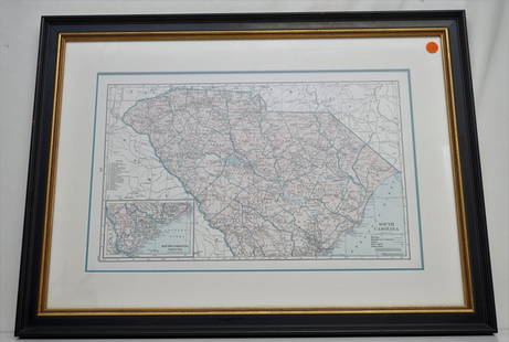
Sold2021HAMMONDS COMPLETE MAP OF SOUTH CAROLINAVintage Hammonds Complete Map of South Carolina. Showing all the railroad routes. c. 1930s. Professionally framed and matted. In frame measures 26 3/4"x20"x 1 1/4". Weight 7 pds. PROVENANCE: A PrivateSee Sold Price
Sold20231855 Colton Map of South Carolina -- South CarolinaTitle: 1855 Colton Map of South Carolina -- South Carolina Cartographer: J Colton Year / Place: 1855, New York Map Dimension (in.): 11.8 X 14.5 in. This is a very nice map of South Carolina with insetSee Sold Price
Sold20211938 R Taylor White Pictorial Map of South Carolina --Title: 1938 R Taylor White Pictorial Map of South Carolina -- South Carolina Cartographer: Ruth Taylor White Year / Place: 1938, Boston Map Dimension (in.): 11.6 x 8.5 in. This is Ruth Taylor White'sSee Sold Price
Jun 08Tony Putty Artifacts7 7/8" Copper Breast Plate. Found by a metal detectorist in South Carolina. Ex Ray Franks and$50
Jun 04Toomey & Co. AuctioneersFrank Lloyd Wright, Architectural element from the Auldbrass Plantation, Yemassee, South Carolina$500
5 days LeftFreeman's | Hindman[CIVIL WAR - SOUTH CAROLINA ACT OF SECESSION]. An Ordinance. To dissolve the Union between the State$7,500
P.A.C.C. Auction Gallery LLCArrowheads Frame of 7 points from South Carolina Burkheim collection largest 2"$8(4 bids)
6 days LeftLink Auction GalleriesSandra Brett, South Carolina 20th Century, Landscape with Rolling Hills, pastel on paper$100
5 days LeftFreeman's | Hindman[AFRICAN AMERICANA - RECONSTRUCTION]. Radical Members of the South Carolina Legislature. Columbia,$250
Jun 08Early American History Auctions1787 Patriot JOHN JULIUS PRINGLE as South Carolina Assembly Speaker, Travel Reimbursement$850
708 Lots AwayHeartland Artifact Auctions Inc2000 United States of America South Carolina State Quarter Off Center Strike$10
Jun 08Potter & Potter Auctions“Okito” Money Maker. South Carolina: Algonquin McDuff (Rhett Bryson), ca. ...$125
3 days LeftMynt AuctionsGEORGE ROGERS SOUTH CAROLINA GCOCKS JSA/COA SIGNED OFFICIAL LICENSED NIKE JERSEY$10
5 days LeftMynt AuctionsGEORGE ROGERS SOUTH CAROLINA HT80 W/COA SIGNED OFFICIAL LICENSED CHAMPION JERSEY$10
5 days LeftMynt AuctionsBryan Edwards Autographed South Carolina Logo Football - JSA Witnessed COA$10


![[CIVIL WAR, CURRENCY]. Group of Confederate Currency: Group of 14 antebellum Southern and Confederate currency notes. 5 antebellum notes, including: Planters Bank of Fairfield $10 note. Winnsboro, South Carolina, 1853. -- The Bank of East Tennessee $2 no](https://p1.liveauctioneers.com/7226/305222/164413258_1_x.jpg?height=310&quality=70&version=1700181801)


![Emanuel Bowen Map North & South Carolina, Georgia: [Emanuel Bowen Map of North & South Carolina and Georgia] , "A New & Accurate Map of the Provinces of North & South Carolina Georgia & c. Drawn from late Surveys and regulated by Astron Observat. By E](https://p1.liveauctioneers.com/268/293228/155705053_1_x.jpg?height=310&quality=70&version=1687296979)


![[CIVIL WAR - SOUTH CAROLINA ACT OF SECESSION]. An Ordinance. To dissolve the Union between the State (1 of 2)](https://p1.liveauctioneers.com/197/329785/177758237_1_x.jpg?height=282&quality=70&version=1715625218)


![[AFRICAN AMERICANA - RECONSTRUCTION]. Radical Members of the South Carolina Legislature. Columbia, (1 of 2)](https://p1.liveauctioneers.com/197/329785/177758475_1_x.jpg?height=282&quality=70&version=1715625218)


