Sold20211938 R Taylor White Pictorial Map of South Carolina --Title: 1938 R Taylor White Pictorial Map of South Carolina -- South Carolina Cartographer: Ruth Taylor White Year / Place: 1938, Boston Map Dimension (in.): 11.6 x 8.5 in. This is Ruth Taylor White'sSee Sold Price
Sold20221938 R Taylor White Pictorial Map of South Carolina -- South CarolinaTitle: 1938 R Taylor White Pictorial Map of South Carolina -- South Carolina Cartographer: Ruth Taylor White Year / Place: 1938, Boston Map Dimension (in.): 11.6 x 8.5 in. This is Ruth Taylor White'sSee Sold Price
Sold20211938 R Taylor White Pictorial Map of South Dakota --Title: 1938 R Taylor White Pictorial Map of South Dakota -- South Dakota Cartographer: Ruth Taylor White Year / Place: 1938, Boston Map Dimension (in.): 11.6 x 8.5 in. This is Ruth Taylor White's charSee Sold Price
Sold20201938 R Taylor White Pictorial Map of North Carolina --Title: 1938 R Taylor White Pictorial Map of North Carolina -- North Carolina Date: 1938, Boston Cartographer: Ruth Taylor White Size: 11.6 x 8.5 in. Additional Information: This is Ruth Taylor White'sSee Sold Price
Sold20181938 R Taylor White Pictorial Map of CaliforniaTitle/Content of Map: 1938 R Taylor White Pictorial Map of California -- California Date Printed: 1938, Boston Cartographer: Ruth Taylor White Size: 11.6 x 8.5 in. This is Ruth Taylor White's charmingSee Sold Price
Sold20181938 R Taylor White Pictorial Map of Florida -- FloridaTitle/Content of Map: 1938 R Taylor White Pictorial Map of Florida -- Florida Date: 1938, Boston Cartographer: Ruth Taylor White Size: 11.6 x 8.5 in. This is Ruth Taylor White's charming pictorial mapSee Sold Price
Sold20201938 R Taylor White Pictorial Map of Hawaii and SamoaTitle: 1938 R Taylor White Pictorial Map of Hawaii and Samoa -- Territory of Hawaii [with] Samoa Cartographer: Ruth Taylor White Year/Place: 1938, Boston Size: 11.6 x 8.5 in. Description: This is RuthSee Sold Price
Sold20181938 R Taylor White Pictorial Map of Hawaii and SamoaTitle/Content of Map: 1938 R Taylor White Pictorial Map of Hawaii and Samoa -- Territory of Hawaii [with] Samoa Date Printed: 1938, Boston Cartographer: Ruth Taylor White Size: 11.6 x 8.5 in. This isSee Sold Price
Sold20231938 R Taylor White Pictorial Map of Hawaii and Samoa -- Territory of Hawaii [with] SamoaTitle: 1938 R Taylor White Pictorial Map of Hawaii and Samoa -- Territory of Hawaii [with] Samoa Cartographer: Ruth Taylor White Year / Place: 1938, Boston Map Dimension (in.): 11.6 x 8.5 in. This isSee Sold Price
Sold20221938 R Taylor White Pictorial Map of Texas -- TexasTitle: 1938 R Taylor White Pictorial Map of Texas -- Texas Cartographer: Ruth Taylor White Year / Place: 1938, Boston Map Dimension (in.): 11.6 x 8.5 in. This is Ruth Taylor White's charming pictorialSee Sold Price
Sold20211938 R Taylor White Pictorial Map of Texas -- TexasTitle: 1938 R Taylor White Pictorial Map of Texas -- Texas Cartographer: Ruth Taylor White Year / Place: 1938, Boston Map Dimension (in.): 11.6 x 8.5 in. This is Ruth Taylor White's charming pictorialSee Sold Price
Sold20211938 R Taylor White Pictorial Map of the PhilippineTitle: 1938 R Taylor White Pictorial Map of the Philippine Islands -- Philippine Islands Cartographer: Ruth Taylor White Year / Place: 1938, Boston Map Dimension (in.): 11.6 x 8.5 in. This is Ruth TaySee Sold Price
Sold20181938 R Taylor White Pictorial Map of Colorado --Title/Content of Map: 1938 R Taylor White Pictorial Map of Colorado -- Colorado1938, Boston Cartographer: Ruth Taylor White Size: 8.5 11.6 in. This is Ruth Taylor White's charming pictorial map, or caSee Sold Price
Sold20181938 R Taylor White Pictorial Map of the PhilippineTitle/Content of Map: 1938 R Taylor White Pictorial Map of the Philippine Islands -- Philippine Islands Date Printed: 1938, Boston Cartographer: Ruth Taylor White Size: 11.6 x 8.5 in. This is Ruth TaySee Sold Price
Sold20181938 R Taylor White Pictorial Map of Kansas -- KansasTitle/Content of Map: 1938 R Taylor White Pictorial Map of Kansas -- Kansas Date: 1938, Boston Cartographer: Ruth Taylor White Size: 11.6 x 8.5 in. This is Ruth Taylor White's charming pictorial map,See Sold Price
Sold20181938 R Taylor White Pictorial Map of the Caribbean andTitle/Content of Map: 1938 R Taylor White Pictorial Map of the Caribbean and Central America -- This Map locates the Panama Canal Zone, Porto Rico and Virgin Islands in Central America and the West InSee Sold Price
Sold20201938 R Taylor White Pictorial Map of New Jersey -- NewTitle/Content of Map: 1938 R Taylor White Pictorial Map of New Jersey -- New Jersey Cartographer: Ruth Taylor White Year/Place: 1938, Boston Size: 11.6 x 8.5 in. This is Ruth Taylor White's charming pSee Sold Price
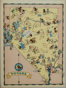
Sold20211938 R Taylor White Pictorial Map of Nevada -- NevadaTitle: 1938 R Taylor White Pictorial Map of Nevada -- Nevada Cartographer: Ruth Taylor White Year / Place: 1938, Boston Map Dimension (in.): 11.6 x 8.5 in. This is Ruth Taylor White's charming pictoriSee Sold Price
Sold20201938 R Taylor White Pictorial Map of Utah -- UtahTitle/Content of Map: 1938 R Taylor White Pictorial Map of Utah -- Utah Date: 1938, Boston Cartographer: Ruth Taylor White Size: 11.6 x 8.5 in. This is Ruth Taylor White's charming pictorial map, or cSee Sold Price
Sold20211938 R Taylor White Pictorial Map of Massachusetts --Title: 1938 R Taylor White Pictorial Map of Massachusetts -- Massachusetts Cartographer: Ruth Taylor White Year / Place: 1938, Boston Map Dimension (in.): 11.6 x 8.5 in. This is Ruth Taylor White's chSee Sold Price
Sold20201938 R Taylor White Pictorial Map of Georgia -- GeorgiaTitle/Content of Map: 1938 R Taylor White Pictorial Map of Georgia -- Georgia Cartographer: Ruth Taylor White Year/Place: 1938, Boston Size: 11.6 x 8.5 in. This is Ruth Taylor White's charming pictoriSee Sold Price
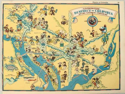
Sold20211938 R Taylor White Pictorial Map of Washington D.C. --Title: 1938 R Taylor White Pictorial Map of Washington D.C. -- Washington District of Columbia the National Capital Cartographer: Ruth Taylor White Year / Place: 1938, Boston Map Dimension (in.): 11.6See Sold Price
Sold20211938 R Taylor White Pictorial Map of the United StatesTitle: 1938 R Taylor White Pictorial Map of the United States -- The United States of America Cartographer: Ruth Taylor White Year / Place: 1938, Boston Map Dimension (in.): 11.6 x 8.5 in. This is RutSee Sold Price
Sold20191938 R Taylor White Pictorial Map of Michigan --Title/Content of Map: 1938 R Taylor White Pictorial Map of Michigan -- Michigan Date: 1938, Boston Cartographer: Ruth Taylor White Size: 11.6 x 8.5 in. This is Ruth Taylor White's charming pictorial mSee Sold Price
May 16Potter & Potter AuctionsLANGENECKERT. It’s A Dog’s World. 1968. St. Louis: Ralston ...$100
May 16Potter & Potter AuctionsHANDY, R.D. (1879 – 1959). Paul Bunyan’s Pictorial Map of t...$200
May 15University ArchivesScarce Early Printing: "An Account of the European Settlement in America in 6 Parts..."$100
May 16Potter & Potter AuctionsPOLAND, Edwin Christian (1903 – 1991). The Evergreen Playgr...$200
May 16Zikorn Arts & History ObjectsThe Soldier in Our Civil War a Pictorial History 1861- 65, 2 Vols$200
24 hrs LeftBucklinIshioka, Eiko; Coppola, Francis Ford; Eiko On Stage [RARE 2000 CALLOWAY FIRST EDITION - FINE COPY]$60(2 bids)
24 hrs LeftBucklinBourke-White, Margaret; Caldwell, Erskine; Have you seen their Faces [1937 VIKING PRESS 1ST EDITION$150
May 11Trillium Antique Prints & Rare BooksCatesby, Folio - Plumeria Flore Niveo (White Frangipanni). 2-93$200
1 day LeftTrillium Antique Prints & Rare BooksCatesby, Folio - Blackcap Flycatcher on Yellow Jessamy. 1-53$200
1 day LeftTrillium Antique Prints & Rare BooksCatesby, Folio - Zebra Swallow-Tail Butterfly with Prickly Apple. 2-100$200
BonhamsDARWIN'S FIRST BOOK. DARWIN, CHARLES. 1809-1882. Journal of Researches into the Geology and Natu...$9,000
24 hrs LeftJay Anderson AuctionCirca 1850's Early Pine Plank Seat Scroll Seat Rocker - found in South Carolina Estate -height 36"$10(1 bid)


![1938 R Taylor White Pictorial Map of Hawaii and Samoa: Title: 1938 R Taylor White Pictorial Map of Hawaii and Samoa -- Territory of Hawaii [with] Samoa Cartographer: Ruth Taylor White Year/Place: 1938, Boston Size: 11.6 x 8.5 in. Description: This is Ruth](https://p1.liveauctioneers.com/5584/169916/85621317_1_x.jpg?height=310&quality=70&version=1591137604)
![1938 R Taylor White Pictorial Map of Hawaii and Samoa: Title/Content of Map: 1938 R Taylor White Pictorial Map of Hawaii and Samoa -- Territory of Hawaii [with] Samoa Date Printed: 1938, Boston Cartographer: Ruth Taylor White Size: 11.6 x 8.5 in. This is](https://p1.liveauctioneers.com/5584/117342/60336911_1_x.jpg?height=310&quality=70&version=1520389291)
![1938 R Taylor White Pictorial Map of Hawaii and Samoa -- Territory of Hawaii [with] Samoa: Title: 1938 R Taylor White Pictorial Map of Hawaii and Samoa -- Territory of Hawaii [with] Samoa Cartographer: Ruth Taylor White Year / Place: 1938, Boston Map Dimension (in.): 11.6 x 8.5 in. This is](https://p1.liveauctioneers.com/5584/274166/143946169_1_x.jpg?height=310&quality=70&version=1673389176)


![[Civil War] (3) Confederate Currency Notes (1 of 2)](https://p1.liveauctioneers.com/7226/325455/175169120_1_x.jpg?height=282&quality=70&version=1712370394)


![Ishioka, Eiko; Coppola, Francis Ford; Eiko On Stage [RARE 2000 CALLOWAY FIRST EDITION - FINE COPY] (1 of 14)](https://p1.liveauctioneers.com/8658/325945/175541737_1_x.jpg?height=282&quality=70&version=1712964944)


