Sold2022Lambertville and Two Clinton NJ MapsClinton Maps are approx 19"x25", Lambertville is approx 26" x 40". All are reprints.See Sold Price
Sold2018Two Maps - Duttons, NY and Essex, NJA Map Showing The New Locale of Dutton, Inc. 270 Park Avenue. 20" x 15"; South Moutain Reservation Essex County Park System map, 1937. 13" x 26"See Sold Price
Sold2024LOT OF VINTAGE MILK BOTTLESINCLUDING: TWO HIRSCHMAN'S PINTS (FLORENCE, NJ), MAPLEHURST PINT (LAMBERTVILLE), 1/2 PINT WOOD-BROOK (PLAINFIELD, NJ) , PROVINCE LINE FARM, PRINCETON AND MORE. Terms: PLEASE READ CAREFULLY BEFORE BIDDSee Sold Price
Sold2023Mark Pullen (American) At Havana BalletOil on canvas, an interior with two figures, signed at the lower right. New Jersey / Pennsylvania border raised between his Uncles PA farm and in Bucks County and Lambertville NJ ,surrounded by artistSee Sold Price
Sold2019Two Maps by the Hydrographic Office U. S. Navy,Two Maps by the Hydrographic Office U. S. Navy, consisting of "China- East Coast- Hwangpoo River, Kaokiao Creek to Yangtzepoo Creek," 1931, H. - 42 in., W. - 30 in.; together with "China- East Coast-See Sold Price
Sold2024Two Maps of the United States by William Faden (London, 1785 and 1796)Two Maps of the United States by William Faden (London, 1785 and 1796) Two hand-colored maps engraved by William Faden (British, 1749-1836), London, 1785 and 1796. Titled "The United States of North ASee Sold Price
Sold2019Two Maps by Matthaus Seutter (1678-1757), "AccurataTwo Maps by Matthaus Seutter (1678-1757), "Accurata Delineatio Celeberrimae Regionis Ludocianae vel Gallice Louisiane al Canadae et Floridae adpellatione in Septemtrionali America, Mississippi, St. LoSee Sold Price
Sold2019Two Maps by Willem Janszoon Blaeu (1571-1638),Two Maps by Willem Janszoon Blaeu (1571-1638), "Virginiae partis australis et Florida partis orientalis," 1640, hand colored, H. - 15 in., W. - 20 in.; together with India Quae Orientalis Diktur et InSee Sold Price
Sold2022Ortelius and Hondius - Two Maps, Florida and Caribbeanincluding: Abraham Ortelius (1527-1598), La Florida/Guastecan/Peruviae Auriferae Regionis Typus, Amsterdam, circa 1584-1609, text verso, in two sheets, engraving on laid paper with hand colored highliSee Sold Price
Sold2021Two Maps of Southwestern American InterestTwo Maps of Southwestern American Interest comprising the Map Of The Route Pursued In 1849 By The U.S. Troops, Under the Command of Bvt. Lieut. Col. Jno. M. Washington, Governor [of] New Mexico, in anSee Sold Price
Sold2015Two maps of the Sandwich Islandsincluding Charte von den Sandwich Inseln by James Cook (1728- 1779), published in Des Capitan Jacob Cook's dritte Entdeckungsreise, 1788, depicting Cook's route through the Sandwich Islands/Hawaii, wiSee Sold Price
Sold2022John Reilly Lambertville ? NJ Oil on Board PaintingSigned Painting is approx 22" x 25 3/4"See Sold Price
Sold2022John Reilly Oil on Board Painting Lambertville NJSigned Painting of Lambertville NJ or New Hope Tow Path. Approx 48" x 38"See Sold Price
Sold2019Two Maps by Abraham Ortelius (1527-1598), "PeruviaeTwo Maps by Abraham Ortelius (1527-1598), "Peruviae Auriferae Regionis Typus, La Florida Aue Torre Hieron Chiaues, Guastecan Reg," each containing three hand colored maps on two sheets, 1595, hand colSee Sold Price
Sold2023Giambattista Albrizzi. Two Maps of North America(Italian, 1698-1777). Map of North America and map of Canada and the Great Lakes, 1740, engravings, sight size of each: 13 1/2 x 17 in., both framed.See Sold Price
2016Robert McClellan, A Small Community, Lambertville NJOil on Board, 12 x16" This item ships from Doylestown, PASee Sold Price
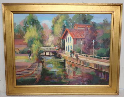
Sold2022John Reilly Lambertville NJ Oil PaintingJohn Reilly Signed Oil on Wood Painting of Lambertville New Jersey Trading is approx 43 3/4" x 23 1/2"See Sold Price
Sold2023John Reilly Clinton NJ Mill Oil on Board PaintingOil on Board Painting. Approx 25 1/4" x 32"See Sold Price
Sold2019Two Maps by Jean Baptiste D'Anville (1699-1782), "Two Maps by Jean Baptiste D'Anville (1699-1782), " America Septentrionales, Coloniis lnteriorem Virginiam deductis, Ohio," 1756 and 1777, H. - 20 in., W. - 23 5/8 in. (2 Pcs.)See Sold Price
Sold2019Two Maps by Olfert Dapper (1636-1689), "Nova VirginiaTwo Maps by Olfert Dapper (1636-1689), "Nova Virginia Tabula, " 1650, H. - 12 1/4 in., W. - 15 in.See Sold Price
Sold2022John Reilly Lambertville NJ PaintingSigned Oil on board winter scene painting is approx 13 1/2" x 17 1/2"See Sold Price
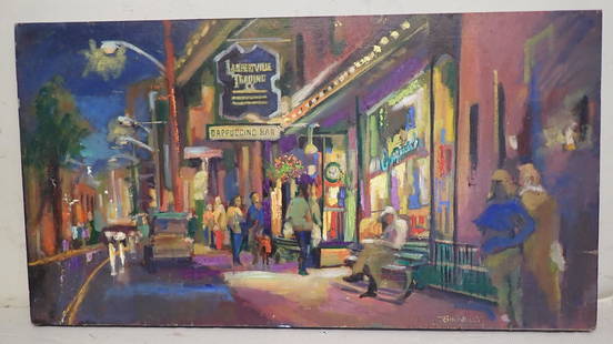
Sold2022John Reilly Lambertville NJ Oil PaintingSigned Oil on board painting is apprx 20" x 51 1/2" . Titled " Say Night Night".See Sold Price
Sold2024Two Maps of Switzerland Including MollProperty from the Estate of a Swiss UBS Executive, Zurich and Hilton Head Island, SC Description: Two Maps of Switzerland Including Moll, including H. Moll, from Atlas Minor, Published London, 172See Sold Price
Sold2021John Reilly Lambertville NJ Oil on Board PaintingSigned and is Approx 31 1/2" x 37" . John Reilly (1942-2021) was born in Brooklyn New York. John received his early art training at the School of Art and Design in Manhattan, where he studied advertisSee Sold Price
Oct 17Julien's AuctionsChristine McVie | Bill Clinton 1993 Presidential Inauguration Fleetwood Mac Performance Ephemera$500
Nov 12J. Greenstein & Co., Inc.TWO MAPS OF THE HOLY LAND. Exceptionally large. Probably used for classroom instruction.$50
Oct 18Rail & Road Auctions1878 Maps of the New and Popular St. Louis and Texas Short Line Railroad Color Lithograph$40(1 bid)
2 hrs LeftNY Elizabeth 1741 AN ANCIENT HISTORY OF THE CONQUEST OF MEXICO SPANISH ILLUSTRATED FOLIO$150(2 bids)
3 days LeftJasper52LONDON UNDERGROUND tube map plan diagram. Northern Heights SCHLEGER/ZERO #3 1939$260
3 days LeftJasper52LONDON UNDERGROUND tube map diagram plan. Northern Heights SCHLEGER/ZERO #2 1939$260
2 hrs LeftNY Elizabeth THE 1853 EXPLORATION OF LOUISIANA'S RED RIVER IN 1852, AS SEEN IN AN ANCIENT ILLUSTRATION$50


![Two Maps of Southwestern American Interest: Two Maps of Southwestern American Interest comprising the Map Of The Route Pursued In 1849 By The U.S. Troops, Under the Command of Bvt. Lieut. Col. Jno. M. Washington, Governor [of] New Mexico, in an](https://p1.liveauctioneers.com/197/208667/106254762_1_x.jpg?height=310&quality=70&version=1624480701)