Sold2016Tunison: Tunison's Map of Colorado Colored LithoTunison: Tunison's Map of Colorado Colored Lithograph, measures 12''H x 9.75''WSee Sold Price
Sold2020Life in the Rocky Mountains by Ferris 1983Life in the Rocky Mountains by Warren Angus Ferris. 1983, new revised edition. The Old West Publishing Co., Denver, Colorado. 444 pp. with map in back pocket. Like-new. Measures 9.25 in. x 6.25 in. xSee Sold Price
Sold2016Cram: Map of Texas, Indian TY, Colorado, 1884Map: Texas, Indian TY, Colorado Maker: George Cram Date: 1884 Origin: Chicago Size: 11.8 x 17 inches (9.5 x 12 verso) Handsomely detailed map of Texas, with the Panhandle as insert. Colorado and IndiaSee Sold Price
Sold20224-Circa 1920's Tourist Guide Road Mapsrated 7 to 8, 9"x4", all have wear, slightly yellowed, one the seams are coming loose, Missouri, Colorado, Oklahoma & Arizona.See Sold Price
Sold2023Diyas Colorado 9 Light Sphere Crystal ChandelierAfter Diyas Colorado 9 Light Sphere Crystal Bubble Pendant Chandelier. 24 inches in diameter.See Sold Price
Sold2023Diyas Colorado 9 Light Sphere Crystal ChandelierAfter Diyas Colorado 9 Light Sphere Crystal Bubble Pendant Chandelier. 24 inches in diameter.See Sold Price
Sold2024The Granger Rod By Goodwin Granger Colorado 9' 6" Very Clean RodThe Granger Rod By Goodwin Granger Colorado 9' 6" Very Clean Rod. // Provenance: PRIVATE ESTATE CENTRAL FLORIDA. Please carefully read our terms of sale, shipping information, and request any conditioSee Sold Price
Sold2021NYC Bridge Dept Maps - 9 boxes! USGS Linen MountedAn interesting set of 9 boxes that are loaded with folding, linen mounted USGS quadrangle sections with hand done high-lights of what I think the New York Central did for their "Bureau of Bridges". EaSee Sold Price
Sold20191806 La Borde Spain Maps (9)Nine engravings of different views of Spain by La Borde, 1806. Includes: Barcelona, Granada, Toledo, Burgos, Cadix, Valladolid, Sagunto, Lerida and a part of Spain. Image sizes measure from 9.375 in.See Sold Price
Sold20211895 Colorado MapAuthor: Cram Title: 1895 Colorado Map Medium: Ink on Paper Dimensions: 22.5"X14.5" Description: Map of Colorado dated 1895. Printed by George Cram for Walker's International Atlas. Published in ChicagSee Sold Price
Sold2024Burgess & Cain 1853 Map #9 Wisc and MichTitle: Burgess & Cain 1853 Map #9 Wisc and Mich Dimension: 11 ½” x 9 ½” Provenance:A beautiful colored map of what were the middle states in 1853. It shows all the major cities,See Sold Price
Sold20211890 Colorado MapTitle: 1890 Colorado Map Author: Watson Medium: Ink on Paper Dimensions: 13.5"X11" Description: Map of Colorado dated 1890. Published by Watson in Chicago. Part of his World Atlas. Key lower right. PrSee Sold Price
Sold20211889 Colorado MapAuthor: Cram Title: 1889 Colorado Map Medium: Ink on Paper Dimensions: 14.5"X11.5" Map of Colorado dated 1889. Printed and published by Watson in Chicago. Key lower left. Explanation on population, ciSee Sold Price
Sold2021A Regency Rosewood EtagereA Regency Rosewood Etagere Circa 1820 Height 48 x width 20 1/2 x depth 16 inches. Provenance: Bryan and Scott Jewelers Ltd., Colorado Springs, Colorado, 9 December 1995 Patricia Ann Black Smyth (1925-See Sold Price
Sold2020Antique Map Architect Blue Print Sea Captain Chest 9 drAntique Map Architect Blue Print Sea Captain Chest 9 drawers custom made flat file cabinet for sea captain architect or blue prints,Maps, 9 drawers all on roller glides drawers work great very good coSee Sold Price
Sold2023Historical Atlas of Santa Clara Co., 1876, Very Rare 1876 [172888]Very rare 1876 Historical Atlas of Santa Clara, Co by Thompson and West. First edition with new binding but original cover and corners. 21 handcolored maps, 9 are double pages. 109 lithograph views. NSee Sold Price
Sold2020Antique Map Architect Blue Print Sea Captain Chest 9 drcustom made flat file cabinet for sea captain architect or blue prints,Maps, 9 drawers all on roller glides drawers work great very good condition see all pics 34 1/2" tall x 41 1/2" wide x 28" deeploSee Sold Price
Sold2024Texaco Touring map service display tin metal signTexaco map holder with maps. 9" H x 4" W x 2.5" D.See Sold Price
Sold2023Davis-Bridaham Drug Co. Jug [157990]J56 in Preble. Davis-Bridaham Drug. Co./Denver, Colorado. 9.5x7.5". .25 and .5"side chips, 3/8" base chip.Date: Country: State: ColoradoCity: DenverProvenance: Gary Bracken CollectionSee Sold Price
Sold201810 Maps, mainly Rollin's Ancient History, 1739-40.[Middle East/Mediteranean/Antiquities] 10 Maps. ++ 9 maps after D’Anville from an edition of Rollin’s “Ancient History…,” cartouches 1739-1740, (nd). Various regions of the ancient Middle EaSee Sold Price
Sold2022Group of 15+ Assorted Train MapsIncludes Colorado, Map of Long Island, Contrail System map, and more.See Sold Price
Sold2022(FLORIDA.) Garcia Lasso de la Vega. Histoire de la Conqueste de la Floride.(FLORIDA.) Garcia Lasso de la Vega. Histoire de la Conqueste de la Floride. [xxvi], 582 pages, 2 title-pages in red and black with engraved vignettes, engraved folding map, 9 engraved folding plates.See Sold Price
Sold2024Voyage a la Baye de Hudson, Fait en 1746...[Exploration] Ellis, Henry. Voyage a la Baye de Hudson, Fait en 1746 & 1747. D'Elie Luzac, Leiden, 1750. 8vo. Frontis folding map, 9 plates, xxviii, 413, [1] pp. Contemporary mottled calf. Minor rubbiSee Sold Price
Sold2024SILENT TEACHER & DISSECTED US MAP305. SILENT TEACHER & DISSECTED US MAP | 9.5? l. | (Very Good to Excellent Condition) | $100 - $200See Sold Price
1 day LeftSchilb Antiquarian Rare Books1831 Northern Traveller Voyages to NIAGARA Falls Quebec Canada Illustrated MAPS$52(4 bids)
6 days LeftSwann Auction Galleries(AMERICAN REVOLUTION--HISTORY.) William Gordon. The History of the Rise, Progress, and Establishment$1,500
4 days LeftJasper521865 Colton Map of US Southwest -- Colton's Map of California, Nevada, Utah, Colorado, Arizona & New$160
4 hrs LeftCheck the Oil Promotions, LLCTexaco Travel Service Advertising Map Rack Display with 50 Maps$225(5 bids)
4 hrs LeftCheck the Oil Promotions, LLCTexaco Touring Service Advertising Map Rack Display with 15 Maps$100(3 bids)
Freeman's | Hindman[MAPS-THE AMERICAS]. 11 maps, incl. [Herrera y Tordesillas]. Descripcion de las Yndias Ocidentales. $250
3 days LeftJasper52The Rise and Fall of the Roman Empire 9 of 12 Volumes 1815 Leather Maps Gibbon$1,000
5 days LeftJasper52GUADELOUPE & MARIE-GALANTE. Soufrière. Dugommier. Antilles. VUILLEMIN 1879 map$25
Jun 30Heartland Artifact Auctions Inc1 9/16" Elko, Motley COA, Highly Translucent Agate material, found in Larimar Co., Colorado$10(1 bid)


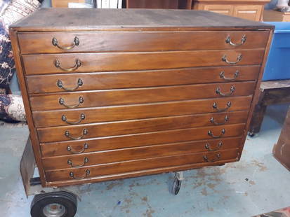
![Colorado Mine Maps, 9 [154531] First Image](https://p1.liveauctioneers.com/2699/258191/134291008_1_x.jpg?height=300&quality=1&version=1660351799&width=300)
![Colorado Mine Maps, 9 [154531] First Image](https://p1.liveauctioneers.com/2699/258191/134291008_1_x.jpg?height=300&quality=95&version=1660351799&width=300)


![Historical Atlas of Santa Clara Co., 1876, Very Rare 1876 [172888]: Very rare 1876 Historical Atlas of Santa Clara, Co by Thompson and West. First edition with new binding but original cover and corners. 21 handcolored maps, 9 are double pages. 109 lithograph views. N](https://p1.liveauctioneers.com/2699/311015/166404935_1_x.jpg?height=310&quality=70&version=1701193470)


![Davis-Bridaham Drug Co. Jug [157990]: J56 in Preble. Davis-Bridaham Drug. Co./Denver, Colorado. 9.5x7.5". .25 and .5"side chips, 3/8" base chip.Date: Country: State: ColoradoCity: DenverProvenance: Gary Bracken Collection](https://p1.liveauctioneers.com/2699/274463/144089205_1_x.jpg?height=310&quality=70&version=1672966071)
![10 Maps, mainly Rollin's Ancient History, 1739-40.: [Middle East/Mediteranean/Antiquities] 10 Maps. ++ 9 maps after D’Anville from an edition of Rollin’s “Ancient History…,” cartouches 1739-1740, (nd). Various regions of the ancient Middle Ea](https://p1.liveauctioneers.com/179/117971/60557774_1_x.jpg?height=310&quality=70&version=1520636872)

![(FLORIDA.) Garcia Lasso de la Vega. Histoire de la Conqueste de la Floride.: (FLORIDA.) Garcia Lasso de la Vega. Histoire de la Conqueste de la Floride. [xxvi], 582 pages, 2 title-pages in red and black with engraved vignettes, engraved folding map, 9 engraved folding plates.](https://p1.liveauctioneers.com/199/251723/130782464_1_x.jpg?height=310&quality=70&version=1655133895)
![Voyage a la Baye de Hudson, Fait en 1746...: [Exploration] Ellis, Henry. Voyage a la Baye de Hudson, Fait en 1746 & 1747. D'Elie Luzac, Leiden, 1750. 8vo. Frontis folding map, 9 plates, xxviii, 413, [1] pp. Contemporary mottled calf. Minor rubbi](https://p1.liveauctioneers.com/179/322586/173446567_1_x.jpg?height=310&quality=70&version=1710359761)


![[MAPS-THE AMERICAS]. 11 maps, incl. [Herrera y Tordesillas]. Descripcion de las Yndias Ocidentales. (1 of 0)](https://p1.liveauctioneers.com/dist/images/placeholder.jpg?height=282&quality=70)


![[Prints] Moran, Thomas: The Mountain of the Holy Cross, Colorado (1 of 3)](https://p1.liveauctioneers.com/65/332523/179335248_1_x.jpg?height=282&quality=70&version=1717709446)


