Sold20231842 MATHER & SMITH WALL MAP OF LONG ISLAND, NYHand-colored lithograph. "A Geological Map of Long & Staten Islands with the Environs of New York"; William W. Mather, geologist and J. Calvin Smith, surveyor. This landmark pre-Civil War map is the eSee Sold Price
Sold20231914 Map Long Island Railroad System and Montauk Steamboat LinesDescription: 914 Map Long Island Railroad System and Montauk Steamboat LinesConnecticut 1855Material: PaperSee Sold Price
Sold20221970s Nautical Navigations Maps Long Island Sound, Block Island & More 47"x35"1970s Nautical Navigations Maps Long Island Sound, Block Island & More 47"x35"See Sold Price
Sold2021Boating Maps, Long Island, Long Island north end, eastMaps from 1981 tropic Isle publishers, Inc. by Harry Klein, Long Island, Long Island Northwynn, East Coast harbors. Size, 11” x17”See Sold Price
Sold20151830 Map of Long Island SoundFrom New York to Mantock Point; published by E. & G.W. Blunt, NY. Printed in three sheetes 24" x 8 1/2", pressure mounted and framed, 26 1/4" x 84 1/4".See Sold Price
Sold2023Framed Map of Long Island by George H. Moore, The Dukes Plan 1859Framed Map of Long Island by George H. Moore, The Dukes Plan 1859. This is an excellent framed map of Long "Isleland." It is labeled, "The Dukes Plan." And it is, "A Description of the towne of MannadSee Sold Price
Sold2023ESTATE OF SEYMOUR STEIN: "A MAP OF LONG ISLAND" FRAMED VINTAGE MAP 22" X 29 1/2" OVERALLESTATE OF SEYMOUR STEIN: "A MAP OF LONG ISLAND" FRAMED VINTAGE MAP 22" X 29 1/2" OVERALLSee Sold Price
Sold20231902 Cram Map of Long Island -- Map of Long Island New YorkTitle: 1902 Cram Map of Long Island -- Map of Long Island New York Cartographer: G Cram Year/Place: 1902, Chicago Dimensions: 9.8 X 12.4 in. Description: This is an attractive map of Long island withSee Sold Price
Sold2022Submarine Map of Long Island Sound, Block IslandSubmarine Map of Long Island Sound, Block Island, together with a book on United States Submarines by Robert Hatfield Barnes with had inscribed dedication to the Officers and the Men of the United StaSee Sold Price
Sold2024Vintage Framed "Map of Long Island" New YorkVintage Framed "Map of Long Island" size: 20 x 27, 23.5 x 29.5 outside frameSee Sold Price
Sold20211897 Map of Long IslandTitle: 1897 Map of Long Island Author: Cram Medium: Ink on Paper Dimensions: 14.5"X11.5" Description: Map of Long Island, New York dated 1897. Printed and engraved by George Cram in Chicago. Key lowerSee Sold Price
Sold2018U.S. Coast Survey 1853 Map of Long Island, New Jersey"Sketch B Showing the progress of Section No. 2" Electrotype Map Published 1843-65, Washington for "Report of the Superintendent of the U.S. Coast Survey..." Published under the supervision and directSee Sold Price
Sold2024Claus Hoie (1911-2007) Long Island WatercolorClaus Hoie (1911-2007) Norwegian, Long Island NY themed watercolor. Dated 1998. A watercolor of Local Landmarks within a map of Long Island, map of Long Island & local landmarks. Including Montauk LigSee Sold Price
Sold2022Newspapers157. Newspapers. Group of newspapers, as listed below. First with map of Long Island. Folio, loose as issued; varying wear, some soiling, margin tears, etc., SOLD-AS-IS. Vp, vd [200/300]Boston CultivaSee Sold Price
Sold2023Map of Connecticut And Rhode Island 1780This early map is titled 'A New and accurate Map of Connecticut and Rhode Island. from the best Authorities' published in the Universal Magazine in 1780. The map features Long Island Sound and NarragaSee Sold Price
Sold2023Revolutionary War Map 1776A copperplate engraving of a map titled “Sketch of the Country Illustrating the late Engagement in Long Island”, which is a Revolutionary War map featuring Long Island and the site of the Battle oSee Sold Price
Sold2022Long Island Pictorial MapA Map of Long Island. Courtland Smith. Billboard Barn: 1933. Vintage map. Scattered creases. Overall 22 1/2" x 30".See Sold Price
Sold2019Long Island, Rand McNally, 1882Early separate map of Long Island from the hard to find 1882 version of McNally’s Indexed Atlas of the World. Shows railroads, towns, islands, lakes, coves, etc. Color by hachure. Near fine with noSee Sold Price
Sold2022Group of 15+ Assorted Train MapsIncludes Colorado, Map of Long Island, Contrail System map, and more.See Sold Price
Sold20231886 J.B. Beers & Co. Map of ConnecticutUnited States,1885 Antique folding map of Connecticut created by J. B. Beers & Co. copyrighted 1885. Print on paper laid on textile,Approx. 52" x 46". From the collection of a Seekonk, Massachusetts eSee Sold Price
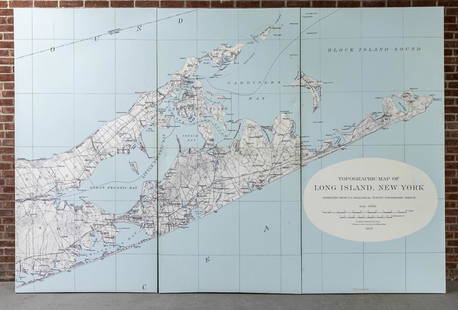
Sold2022Three Panel Water Current Map of Eastern Long Island on Canvas with FrameOver scaled Eastern Long Island water current map on three panel canvas, strengthened on frame. Please note of wear consistent with age. Each panel measures 48"W x 2"D x 96"H.See Sold Price
Sold202263" tall oak Industrial Commercial wall clock, from Long Island estate, large pendulum intact, with63" tall oak Industrial Commercial wall clock, from Long Island estate, large pendulum intact, with a large brass weight, the weight is 10" top to bottom, measures 20" wide x 8.75" deep. Body is in niSee Sold Price
Sold20211873 New England and Long Island MapAuthor: Bartholomew Title: 1873 New England and Long Island Map Medium: Ink on Paper Dimensions: 13"X17.5" Map of New England and Long Island dated 1873. Part of Zell's Descriptive Hand Atlas of the WSee Sold Price
Sold2022Shirley, Mastic Acres, Long Island Maps (2)Shore.Shirley, Mastic Acres, Long Island Maps (2). Vintage 1950s colorful brochure with map, etc., for Shirley, Long Island, promoting development. With separate Mastic Acres map. Town of Brookhaven,See Sold Price
3 days LeftJasper52The country round Philadelphia. New Jersey Pennsylvania NY. GENTS MAG 1776 map$320
3 days LeftJasper52Rhode Island, part of Connecticut & Massachusetts shewing… LODGE 1780 old map$500
3 days LeftJasper52A plan of the operations of the King's army… in New York… FADEN/STEDMAN 1794 map$6,500
3 days LeftSwann Auction GalleriesLESLIE RAGAN (1897-1972) New York / The Upper Bay from Lower Manhattan. 1935.$3,800
3 days LeftSwann Auction GalleriesADOLPH TREIDLER (1886-1981) New York / The Wonder City of the World. 1927.$6,000
3 days LeftJasper52Part of the Western Coast of Africa…' by James Wyld. Sierra Leone 1840 old map$300
Oct 05Ripley AuctionsBernard Karfiol, Hungary/New York (1886-1952), The Chaise Lounge, 1945, oil on canvas, 11 1/2"H x 15$300
2 days LeftJasper52Sketch B Showing the Progress in Section No. 2 U.S.Coast Survey 1844 to 1850 [Long Island And New$50(1 bid)
5 days LeftHeritage Auctions35020: Leon Kroll (American, 1884-1974) Long Island Sou$750
5 days LeftConestoga Auction Company Division of Hess Auction GroupWall Map of Montgomery County, PA 1849.$50
7 days LeftCurated Gallery AuctionsLong Island 1937 Signed Impressionist Landscape Framed Antique American Original Oil Painting$10
BonhamsFRANCK MULLER | LONG ISLAND RELIEF, REF.952 QZ REL, A NEW OLD STOCK WHITE GOLD WRISTWATCH, CIRCA...HK$17,000


![Newspapers: 157. Newspapers. Group of newspapers, as listed below. First with map of Long Island. Folio, loose as issued; varying wear, some soiling, margin tears, etc., SOLD-AS-IS. Vp, vd [200/300]Boston Cultiva](https://p1.liveauctioneers.com/1352/254382/132649399_1_x.jpg?height=310&quality=70&version=1658086673)