20231859 Map of Texas. By ColtonTitle: 1859 Map of Texas. By Colton Date/Period: 1859 Materials: Hand colored steering engraved Size: 17 1/2 x 14 1/2” br>Texas right before the civil war, inserts the northern part of the stateSee Sold Price
Sold20231859 Map of Texas. By ColtonDescriptionTitle: 1859 Map of Texas. By ColtonDate/Period: 1859Materials: Hand colored steering engravedSize: 17 1/2 x 14 1/2”br>Texas right before the civil war, inserts the northern part of thSee Sold Price
Sold2019Scarce Colton 1855 map of Texas, Johnson/BrowningScarce large map of Texas with 1855 date, but with Johnson & Browning imprint. The Johnson & Browning imprint was found in only the 1859 Colton atlas and 1860 and 1861 Johnson Family atlases. This mapSee Sold Price
Sold20201859 Colton Map of Paris -- The Environs of ParisTitle: 1859 Colton Map of Paris -- The Environs of Paris Cartographer: J Colton Year/Place: 1859, New York Size: 12.1 X 14.7 in. Additional Information: This is a very attractive city map of greater PSee Sold Price
20231859 Map of Florida by ColtonTitle: 1859 Map of Florida by Colton Date/Period: 1859 Materials: Steel engraved Size: 17 1/2 x 14 1/2” Florida with Florida keys in the insert. From before the civil war. By J. H. Colton & G. WSee Sold Price
Sold20231859 Map of Florida by ColtonTitle: 1859 Map of Florida by Colton1859 Materials: Steel engraved Size: 17 1/2 x 14 1/2” Florida with Florida keys in the insert. From before the civil war. By J. H. Colton & G. W. Colton. From "GeSee Sold Price
Sold20231859 Map of Connecticut by ColtonTitle: 1859 Map of Connecticut by Colton Date/Period: 1859 Materials: Steel engraved Size: 17 1/2 x 14 1/2” Connecticut. Shows, rivers, lakes, counties cities, towns, villages, roads, and rail lSee Sold Price
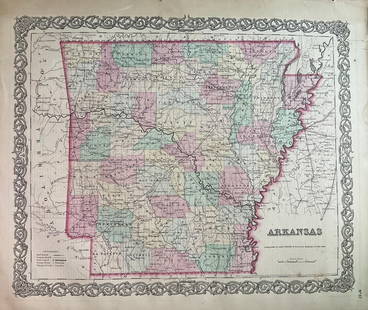
Sold20231859 Map of Arkansas by ColtonTitle: 1859 Map of Arkansas by Colton Date/Period: 1859 Materials: Steel engravedSize: 17 1/2 x 14 1/2” Arkansas. From before the civil war. By J. H. Colton & G. W. Colton. From "General Atlas".See Sold Price
Sold20231859 Southern Africa. Map By ColtonTitle: 1859 Southern Africa. Map By Colton Date/Period: 1859 Materials: Hand colored steering engraved Size: 17 1/2 x 14 1/2” This hand-colored, steel-engraved map showcases the region from theSee Sold Price
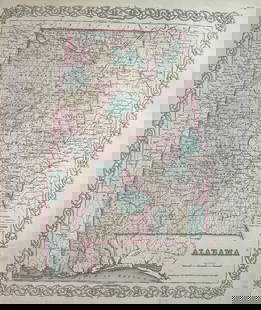
Sold20231859 Map of Alabama by ColtonTitle: 1859 Map of Alabama by Colton Date/Period: 1859 Materials: Steel engravedSize: 17 1/2 x 14 1/2” Alabama. From before the civil war. By J. H. Colton & G. W. Colton. From "General Atlas". PSee Sold Price
Sold20171855 1st Ed. Texas map from Colton’s Atlas of the WorldItem: 1855 1st Ed. Texas map from Colton’s Atlas of the World Description: Counties current to 1854 making this the uncommon and desirable first edition (Tarrant county appears, but not the 1855 addSee Sold Price
2017Colton: Map of Texas, 1855Map: Texas Cartographer: J. H. Colton Illustrator: J. H. Colton Edition: First Edition Publisher: J. H. Colton, Co. Published: New York, 1855 Size: 12.75 x 15.5 inches Counties current to 1854 makingSee Sold Price
Sold20231859 Map of New Jersey by ColtonTitle: 1859 Map of New Jersey by Colton Date/Period: 1859 Materials: Steel engraved Size: 17 1/2 x 14 1/2” New Jersey. By J. H. Colton & G. W. Colton. From "General Atlas". Published in New YorkSee Sold Price
Sold20241859 Map of Netherlands & Belgium by ColtonTitle: 1859 Map of Netherlands & Belgium by Colton Date/Period: 1859 Materials: Steel engraved Size: 17 1/2 x 14 1/2” Netherlands & Belgium. 1859. By J. H. Colton & G. W. Colton. From "General ASee Sold Price
Sold2024Reproduction Map of TexasReproduction of 1855 map of Texas, originally published J.H.Colton and Co. (New York), resting on board, sealed in plastic height 17.75 in. x width 19.5 in. x depth 0 in. Condition: Handwritten "See Sold Price
Sold20241859 Framed Map of The State of Texas from the Latest Authorities1859 framed map of the State of Texas from the Latest Authorities, hand colored sight: 14.5 in. x 17.5 in.,frame: 19.5 in. x 20 in. Shipping available for this lot through our partner 4CL; please rSee Sold Price
Sold2021Scarce Colton 2-page map of Texas, c1884Breathtakingly large, fully hand-colored vintage map of Texas from the very scarce 1890 edition of Colton’s General Atlas. This is the only edition of this atlas that I’ve ever seen—See Sold Price
Sold2017Colton: Antique Map of Texas, 18641860 Colton’s Texas - uncommon. From an 1864 school atlas. This map is not seen very often. Delineates all counties to 1860. Shows topography, forts, railroads, battle fields, rivers, etc. �See Sold Price
Sold2017Colton: Antique Map of Cuba, 1859Title/Content of Map: Cuba by Colton Date Printed: 1859 Cartographer: H. J. Colton Material/Medium: Paper Size: 17 1/2" x 15" Hand colored engraved. Published in New York in 'Colton's General Atlas'.See Sold Price
Sold2018Colton: Antique Map of Georgia, 1859Title/Content of Map: Georgia by Colton Date Printed: 1859 Cartographer: H.J. Colton Material/Medium: Paper Size: 17 1/2" x 15" Hand colored,engraved. Published in New York in 'Colton's General Atlas.See Sold Price
Sold2017Colton: Antique Map of Wisconsin, 1859Title/Content of Map: Wisconsin by Colton Date Printed: 1859 Cartographer: H. J. Colton Material/Medium: Paper Size: 17 1/2" x 15" Hand colored engraved. Published in New York in 'Colton's General AtlSee Sold Price
Sold2018Colton: Antique Map of London, 1859Title/Content of Map: London by Colton Date Printed: 1859 Cartographer: H.J. Colton Material/Medium: Paper Size: 17 1/2" x 15" Hand colored,engraved. Published in New York in 'Colton's General Atlas.'See Sold Price
Sold2018Colton: Antique Map of Prussia, 1859Title/Content of Map: Prussia by Colton Date Printed: 1859 Cartographer: H.J. Colton Material/Medium: Paper Size: 17 1/2" x 15" Hand colored,engraved. Published in New York in 'Colton's General Atlas.See Sold Price
Sold20231859 Map of England and Wales by ColtonTitle: 1859 Map of England and Wales by Colton Date/Period: 1859 Materials: Steel engraved Size: 17 1/2 x 14 1/2” England & Wales. By J. H. Colton & G. W. Colton. From "General Atlas". PublishedSee Sold Price
Featured21 hrs LeftJasper52United States of North America. Early territorial boundaries. LOWRY 1859 map$380
2 days LeftSwann Auction GalleriesEGBERT L. VIELE; and G.W. & C.B. COLTON Map of the City of New York Showing the Proposed Route of$600
7 days LeftJasper521855 Colton Map of Large Nebraska and Kansas Terrritories -- Nebraska and Kanzas$160
Nov 03Modern JewelryNEW 14K YELLOW GOLD TEXAS STATE MAP PENDANT 14K YELLOW GOLD NEW TEXAS STATE MAP PENDANT WEIGHT: 2g$260
21 hrs LeftJasper52AUSTRALIAN COLONIES w/ counties. Predates Queensland (Est. 1859). SDUK 1857 map$380
4 days LeftTrillium Antique Prints & Rare BooksDe L'Isle - Map of Louisiana and the Course of the Mississippi (Eastern America) (First Appearance$240(2 bids)
Oct 12JM Hobby Supply and Railroad Artifact Auctions1882 Indiana Bloomington and Western Railway Map$30
Oct 18Rail & Road Auctions1878 Maps of the New and Popular St. Louis and Texas Short Line Railroad Color Lithograph$40(1 bid)
Oct 12JM Hobby Supply and Railroad Artifact AuctionsLouisville and Nashville RR 1896 Route Map and Letter$20
21 hrs LeftJasper52United States of North America, Pacific States by Joseph Wilson Lowry 1860 map$340