Sold2023Pictorial map of Washington StateHeading: (Washington) Author: Herman, John F. & Chark Teegarden Title: A Pictorial Map of Washington: The Evergreen State"" Place Published: Seattle, WA Publisher:Ridgway Litho. Co. Date PublisheSee Sold Price
Sold2016Map of Washington State, 1895Original engraving from Atlas of the World by Rand McNally, 1895. Map includes counties, geographical landmarks, streets and population data. Dimensions: 21 1/4" x 27 1/2" Shipping Domestic: ShippingSee Sold Price
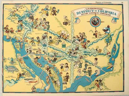
Sold20211938 R Taylor White Pictorial Map of Washington D.C. --Title: 1938 R Taylor White Pictorial Map of Washington D.C. -- Washington District of Columbia the National Capital Cartographer: Ruth Taylor White Year / Place: 1938, Boston Map Dimension (in.): 11.6See Sold Price
Sold20211938 R Taylor White Pictorial Map of Washington --Title: 1938 R Taylor White Pictorial Map of Washington -- Washington Cartographer: Ruth Taylor White Year / Place: 1938, Boston Map Dimension (in.): 11.6 x 8.5 in. This is Ruth Taylor White's charmingSee Sold Price
Sold20201859 Map of Washington state, Oregon and IdahoAuthor: Johnson Title: 1859 Map of Washington state, Oregon and Idaho Medium: Ink on Paper Dimensions: 18"X14.5" Map of Washington state and Oregon dated 1859. Engraved by A.J. Johnson. Published by JSee Sold Price
Sold20211901 Map of Washington StateAuthor: Cram Title: 1901 Map of Washington State Medium: Ink on Paper Dimensions: 22"X14.5" Map of Washington state dated 1901. Printed and published by George Cram in Chicago. Part of his World AtlasSee Sold Price
Sold2021Pictorial Map United States IndiansIndians of the U.S.A. Louise E. Jefferson. Friendship Press, New York: 1944. Novelty map showing native American tribes. Vintage color print. 22 1/2" x 34 1/2", overall 26" x 40".See Sold Price
Sold2018Native American Ledger Art, Cheryl GrunloseFramed Native American ledger art by Cheryl A. Grunlose, Colville Tribes, Washington State. Composition of watercolor and chalks on a vintage map of Washington State. The contemporary drawing "an inteSee Sold Price
Sold2022[PACIFIC NORTHWEST]. Two pictorial maps of Oregon and Washi...[PACIFIC NORTHWEST]. Two pictorial maps of Oregon and Washington. Including: -- PETRUCCELLI, Antonio (1907-1994). Pictorial map of Washington and Oregon. 1940. Art Deco style map of the Pacific NorthwSee Sold Price
Sold2020Native American Ledger Art - Style Cheryl GrunloseFramed Native American ledger art - style by Cheryl A. Grunlose, Colville Tribes, Washington State. Composition of watercolor and chalks on a vintage map of Washington State. The contemporary drawingSee Sold Price
Sold2023Maps of Maryland and Washington State 1865Map of Maryland and Map of Washington State, 1865, smallest 7.75 x 10.5 inches, largest 9 x 12 inches, both unframed.See Sold Price
Sold2023Pictorial map of western WashingtonHeading: (Washington) Author: Title: Good Natured Map - Shrine Playground - Seattle Washington Place Published: Seattle Publisher:Farwest Lithograph & Printing Co. Date Published: 1936See Sold Price
Sold2023Vintage Washington State Maps Topography MapsVintage Washington State Maps Topography Maps This is a set of 5 Washington State Topography Maps that show Surveys from the early 1900s. These are vintage reprints of the initial surveys done. TheseSee Sold Price
Sold20211853-4 Stevens Map of the Rockies to Washington StateTitle: 1853-4 Stevens Map of the Rockies to Washington State -- Map No. 3 Rocky Mountains to Puget Sound… Cartographer: I Stevens Year / Place: 1853-4, Washington Map Dimension (in.): 24.5 X 36.See Sold Price
Sold2024Pictorial Map of the United States, 1849PICTORIAL MAP OF THE UNITED STATES 1849. New York: Ensign and Thayer, [ca. 1849.] Sheet 44" x 32.25".*** An attractive hand-colored map providing a view of the United States as it was in the mid-19thSee Sold Price
Sold2022(PICTORIAL MAPS.) R.D. Handy. Paul Bunyan's Pictorial Map of the United States Depicting Some of His(PICTORIAL MAPS.) R.D. Handy. Paul Bunyan's Pictorial Map of the United States Depicting Some of His Deeds and Exploits. Color-printed lithographed pictorial map comically illustrating many geographicSee Sold Price
Sold20181930s Taylor White Pictorial Map Set of United StatesTitle/Content of Map: 1930s Taylor White Pictorial Map Set of United States for United Airlines -- United Air Lines: A Gay Geography of the Main Line Artery Date: 1930s Cartographer: R Taylor White SiSee Sold Price
Sold20211938 R Taylor White Pictorial Map of the United StatesTitle: 1938 R Taylor White Pictorial Map of the United States -- The United States of America Cartographer: Ruth Taylor White Year / Place: 1938, Boston Map Dimension (in.): 11.6 x 8.5 in. This is RutSee Sold Price
Sold20181938 R Taylor White Pictorial Map of the United StatesTitle/Content of Map: 1938 R Taylor White Pictorial Map of the United States -- The United States of America Date Printed: 1938, Boston Cartographer: Ruth Taylor White Size: 11.6 x 8.5 in. This is RutSee Sold Price
Sold20211938 R Taylor White Pictorial Map of the United StatesTitle: 1938 R Taylor White Pictorial Map of the United States -- The United States of America Cartographer: Ruth Taylor White Year / Place: 1938, Boston Map Dimension (in.): 11.6 x 8.5 in. This is RutSee Sold Price
Sold2022A RARE GRIBBROEK 1935 NATIVE AMERICAN POSTERRobert Gribbroek (1906-1971) historical pictorial map of New York State focused on its Native American tribes by Arthur Caswell Parker (1881-1955). Filled with portraits of prominent persons and sceneSee Sold Price
Sold20151847 Ensigns & Thayer “Pictorial Map of the United1847 Ensigns & Thayer “Pictorial Map of the United States” (chips, minor losses, creases) 29.5” x 41” framedSee Sold Price
Sold20221941 Dudley US Pictorial Map -- America the Wonderland.Title: 1941 Dudley US Pictorial Map -- America the Wonderland. A Pictorial Map of the United States. Designed and Drawn by Ernest Dudley Chase of Winchester, Massachusetts Cartographer: E D Chase YearSee Sold Price
Sold2023CHASE, Ernest Dudley (1878-1966). Two pictorial maps of Ame...CHASE, Ernest Dudley (1878-1966). Two pictorial maps of America. Includes: America the Wonderland / A Pictorial Map of the United States. 1954. Philadelphia: The Inquirer Colorama. Color pictorial mapSee Sold Price
Featured6 hrs LeftJasper52Johnson's New Military Map of the United States Showing the Forts, Military Posts &C. With Enlarged$65
Jun 08Early American History Auctionsc 1797 JOHN ADAMS, President of the United States of America. Historical Liverpool Creamware Pitcher$2,000
3 days LeftMynt AuctionsMark Rypien Autographed Washington State Schutt Mini Helmet w/ Insc-Beckett W Ho$10
5 days LeftMynt AuctionsRYAN LEAF WASHINGTON STATE COUGARS CHARGERS LAST ONE JSA/COA SIGNED JERSEY$10
1 day LeftPacific Global AuctionMarcus Trufant Signed NFL Football Seattle Seahawks Washington State Cougars Proof Beckett Autograph$150
4 days LeftMynt Auctions1947 Penn State Nittany Lions vs. Washington State College FB Program 137585$10
JG AutographsPerry Dahl - WWII Army Air Forces Ace - Autographed Canadian Declaration of War 50 Anniv. Cover$10
6 hrs LeftJasper521878 Mitchell Map of Washington, Oregon, Idaho, much of Montana [verso] Territory of Idaho$55
6 days LeftMynt AuctionsCHRIS THOMPSON WASHINGTON REDSKINS!FLORIDA STATE SEMINOLES JSA/COA SIGNED JERSEY$10


![[PACIFIC NORTHWEST]. Two pictorial maps of Oregon and Washi...: [PACIFIC NORTHWEST]. Two pictorial maps of Oregon and Washington. Including: -- PETRUCCELLI, Antonio (1907-1994). Pictorial map of Washington and Oregon. 1940. Art Deco style map of the Pacific Northw](https://p1.liveauctioneers.com/928/255324/132836177_1_x.jpg?height=310&quality=70&version=1658268357)


![Pictorial Map of the United States, 1849: PICTORIAL MAP OF THE UNITED STATES 1849. New York: Ensign and Thayer, [ca. 1849.] Sheet 44" x 32.25".*** An attractive hand-colored map providing a view of the United States as it was in the mid-19th](https://p1.liveauctioneers.com/3532/326332/175680404_1_x.jpg?height=310&quality=70&version=1713150771)


![1878 Mitchell Map of Washington, Oregon, Idaho, much of Montana [verso] Territory of Idaho (1 of 2)](https://p1.liveauctioneers.com/5584/329422/177662232_1_x.jpg?height=282&quality=70&version=1715717898)

