Sold2022FRAMED MAP OF THE HAMILTON FARM, NEW JERSEY"Map of Hamilton Farm and Adjacent Properties, Bridle Paths, Roads, etc. in Hunterdon, Morris & Somerset Counties, in the State of New Jersey" by F.S. Tainter, March, 1935. Details include Somerset HiSee Sold Price
Sold2019Vintage Road Maps (14)Including 1980-1981 New Jersey map & guide; (3) Somerset & Hunterdon Counties New Jersey map; Burlington Bridges Area Road map; Northern Hunterdon County, NJ map; Sunoco New York map; Texaco Florida,See Sold Price
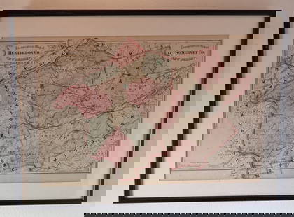
Sold2023Hearne Brothers Somerset County NJ MapPolyconic Projection map. Approx 50" x 65"See Sold Price
Sold2022Hamilton Farm James Cox Brady ResidenceHunterdon Somerset & Morris Counties Map is approx 33 1/2" x 43 1/2"See Sold Price
Sold20221902 Map of Hunterdon County NJ Irving C HicksIrving Hicks Publisher, Pugh & Downing Engineers. Approx 42" x 50 1/2"See Sold Price
Sold2020Road Map of Hunterdon County New JerseyRoad map of Hunterdon County New Jersey. Published and distributed by Hunterdon County Democrat, Flemington, NJ, Delaware Valley News, Frenchtown, NJ. On a blue card stock type paper. Has some loss inSee Sold Price
Sold2023Map of Somerset County, New JerseyMap of Somerset County with inset of Somerville lower right, hand-colored lithograph by J. W. Otley and J. Keily, printed by Lloyd Van Derveer, Camden, NJ, 1850 Overall: 47-3/4"h x 40"w Sight: 44-3/4"See Sold Price
Sold2022John Reilly Hunterdon County NJ PaintingSigned Oil on Board Painting is approx 18 1/8" x 23 7/8"See Sold Price
Sold2022GROUP LOT OF VINTAGE PAPER GOODSINCLUDING: 19TH/20TH C. CORRESPONDENCE, PHOTOS, TRADE CARDS, NJ HISTORY/DIRECTORY, REPRINT OF SUSSEX COUNTY, NJ MAP AND MORE Terms: Hartzell's Auction Gallery will handle most of the shipping in-houseSee Sold Price
Sold20211860 Union Twp Hunterdon Co NJ MapSurveyed Drawn and published by Michael Hughes. Approx 49" x 36"See Sold Price
Sold2016HISTORY OF HUNTERDON AND SOMERSET COUNTIES NEW JERSEYEVERTS & PECK, 1881 - PHILADELPHIASee Sold Price
Sold2016HISTORY OF HUNTERDON AND SOMERSET COUNTIES NEW JERSEYEVERTS & PECK, 1881 - PHILADELPHIASee Sold Price
Sold2018EARLY BOOK LOTINCLUDING - HISTORY OF HUNTERDON AND SOMERSET COUNTIES, NEW JERSEY - (8) VOLUMES OF CHAMBER'S ENCYCLOPEDIA'SSee Sold Price
Sold20231876 Atlas of Illinois- Cook County Map Framed PagTravel back in time to the late 19th century with this enchanting Framed Map Page from the 1876 Atlas of Illinois by Warner & Beers. This exquisite piece showcases the detailed cartography of Cook, DuSee Sold Price
Sold201819TH CENTURY MAP OF HUNTERDON COUNTY. 51 X 40 3/419TH CENTURY MAP OF HUNTERDON COUNTY. 51 X 40 3/4 INCHES.See Sold Price
Sold2021Antique Framed Map of Columbia County, NY 1829Antique Framed Map of Columbia County, NY, dated 1829. Engraved by Rawdon Clark & Co, Albany, NY. Also marked Rawdon Wright, New York. Map includes locations of mills, churches and stage roads. NicelySee Sold Price
Sold2017Framed map of Chester County, Pennsylvania, copyright 1Framed map of Chester County, Pennsylvania, copyright 1938, compiled and drawn by Charles B MuthSee Sold Price
Sold2024FRAMED WARREN COUNTY MAPWARREN CO., NEW JERSEY. MATTED AND FRAMED UNDER GLASS. 29 1/4" X 21 3/4". PLEASE READ CAREFULLY - Terms for Purchasing and Shipping of Auction Items. Please read carefully before bidding. All paymentsSee Sold Price
Sold2020FRAMED MAP OF ROXBURY NJFRAMED MAP OF ROXBURY NJ IT HAS A BUSINESS DIRECTORY & AN INSET OF DRAKESVILLE, OVERALL DIMENSIONS INCLUDING FRAME, 28 1/2 IN 21 1/2 INSee Sold Price
Sold2018FRAMED MAP OF CHESTER COUNTY 1847Framed Map Of Chester County 1847: Dated 1847. This map is adhered to a backing board. Projection and drawing by J.S Bowen, engraved by Edward Yeager of Philadelphia. 50"See Sold Price
Jun 13Swann Auction Galleries(NEW JERSEY.) National View Co. Port au Peck. Near Long Branch, Monmouth Co., New Jersey.$500
3 days LeftRapid Estate Liquidators and Auction GalleryFramed Collection Engravings & A Map From The Excursions In The County Of Sussex Published In 1822$50
5 days LeftEarly American History Auctions1836 Hand-Colored Map, Country Twenty Five Miles Round The City Of New-York Published by D.S. Stone$260
5 days LeftEarly American History Auctions1753 Map of the County of Lancaster Divided into its Hundreds, by Royal Mapmaker Emanuel Bowen$280
Jun 14DuMouchellesWilliam H. Gamble (American, B. 1863) Hand Colored Engraving, Ca. 1863, "County Map of Michigan And$50(1 bid)
6 days LeftThe North Georgia Auction Company LLCClint Alderman Edgefield Area Potteries Map$200(1 bid)
Crawford Family Auctions LLCFramed print of Map of Part of the Island of Hawaii & Sandwich Islands, w/COA$20
4 days LeftHolabird Western Americana CollectionsSanitary & Topographical "Viele Map" of Manhattan 1865 [182838]$750
5 days LeftEarly American History Auctions1720 Colonial Northumberland County Virginia Manuscript Deed and Map Plot$400


![Sanitary & Topographical "Viele Map" of Manhattan 1865 [182838] (1 of 3)](https://p1.liveauctioneers.com/2699/331495/178785766_1_x.jpg?height=282&quality=70&version=1717094933)


