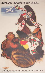
Sold2022Otto Nielsen (1877-1959) South Africa by SAS, original poster printed by Axel Andreasen & SonnerOtto Nielsen (1877-1959) South Africa by SAS, original poster printed by Axel Andreasen & Sonner c.1955 - 100 x 62 cmSee Sold Price
Sold2021Africa (4) Facsimile Reprint BooksCollection of four (4) facsimile reprinted books of Africa. Includes: 1) Across Africa by Cameron. 1877 reprinted in 1969. Note unable to open the map behind the frontispiece, adhered to the front endSee Sold Price
Sold2018HISTOIRE PITTORESQUE ILLUSTREE DES GRANDS VOYAGES AUHISTOIRE PITTORESQUE ILLUSTREE DES GRANDS VOYAGES AU XIXE SIECLE 1877 Decorative Binding Illustrated Engravings Maps Travel & Exploration Eskimo Africa Sandwich Islands Henri Barth Hindoustan Delhi LiSee Sold Price
Sold2023THOMAS BAINES - GOLD REGIONS OF SOUTH EASTERN AFRICA c1877 RARE 1st Ed. Map IntactTHOMAS BAINES - THE GOLD REGIONS OF SOUTH EASTERN AFRICAThis scarce book was published in London by Edward Stanford in 1877 and is the First Edition. It is bound in green blind-stamped cloth with giltSee Sold Price
Sold20201877 Map of FinlandAuthor: Samuelsson Title: 1877 Map of Finland Medium: Ink on Paper Dimensions: 12"X10" Description: Map of Finland dated 1877. Compiled by Dr. Magnus Roth. Engraved and drawn by Otto Wordenskjold andSee Sold Price
Sold20201877 European People and Language MapAuthor: Samuelsson Title: 1877 European People and Language Map Medium: Ink on Paper Dimensions: 12"X10" Map of Europe dated 1877. Compiled by Dr. Magnus Roth. Engraved and drawn by Otto WordenskjoldSee Sold Price
Sold2022MAP, Africa, OrteliusOrtelius' Cornerstone Map of Africa. Africa. Abraham Ortelius, Africae Tabula Nova, from Theatrum Orbis Terrarum, 1570 (dated). Black & White. This striking map is one of the cornerstone maps of AfricSee Sold Price
Sold2021Hand colored map, Africa. 23” x 20.5”Hand colored map, Africa. 23” x 20.5”See Sold Price
Sold2022MAP, Africa, MercatorFull Contemporary Color. Africa. Gerard Mercator, Africa ex Magna Orbis Terre Descriptione Gerardi Mercatoris Desumpta, Studio & Industria, from Atlas sive Cosmographicae..., 1609 (circa). Hand Color.See Sold Price
Sold2022MAP, Africa, OrteliusCentral Africa. Abraham Ortelius, Presbiteri Iohannis, sive, Abissinorum Imperii Descriptio, from Theatrum Orbis Terrarum, 1579 (published). Hand Color. This great map depicts the central African kingSee Sold Price
Sold2020Gastaldi Map of Africa*** START PRICE IS THE RESERVE *** [Africa]. GASTALDI, Giacomo (1500-1566) & FORLANI, Paolo (fl. 1560-1571). La Descrittione dell'Africa. Engraved Map. Venice: Paolo Forlani, 1562. 19 x 25 1/4 inchesSee Sold Price
Sold2017Ortelius: Cornerstone Map of Africa, 1570Title: Africae Tabula Nova Map maker: Abraham Ortelius, Theatrum Orbis Terrarum Place and Year: Antwerp, 1570 Dimensions: 50 x 37.6 cm (19.8 x 14.8 in) Technique: Copperplate engraving Coloring: HandSee Sold Price
Sold2017ANTIQUE MAP OF AFRICA, GERHARD MERCATOR JR.17TH CFramed engraved hand colored map, after 1600, by Gerhard Mercator Jr (his grandfather was Gerhard Mercator, Flemish, 1512-1594), "Africa Ex magna orbis terre descriptione Gerardi Mercatoris desumpta,See Sold Price
Sold2020[Maps & Atlases] [Africa] Ortelius, Abraham, Group of 2[Maps & Atlases] [Africa] Ortelius, AbrahamGroup of 2 MapsBarbariae et Biledulgerid, nova descriptio(Antwerp, ca. 1570-1612). Hand-colored engraving. Coastal map of North Africa and the Mediterranean,See Sold Price
Sold2021Map of Africa After Jocodus Hondius, Aerica NovaMap of Africa After Jocodus Hondius, Aerica Nova Tabula Auct. Jud Hondiowith a distinctive blank cartouche as published in a 1659 Paris edition of Pierre D'Avity's Les Etats, Empires Royaumes du MondeSee Sold Price
Sold2020Ortelius Map of Africa 1570Abraham Ortelius (1527-1598), "Africae Tabula Nova," Antwerp, 1570. This hand colored map of Africa originates from Ortelius' "Theatrum Orbis Terrarum." The map shows political divisions within AfricaSee Sold Price
Sold2022A.H. Jaillot - Monumental Map of AfricaAfrique Divisee en ses Principales Parties et ses Isles 49"x51" Paris, 1782, Framed 58x55x3.5See Sold Price
Sold2022EARLY MAP OF AFRICA"Africae" "Newly Done into English John Speede / G. Humble 1626" engraved by Abraham Goos, bookplate "The Description of Africa" on reverse, hand colored; minor tear, foxing, toning, tape marks; frameSee Sold Price
Sold2020Herman Moll Map of Africa ca. 1720Herman Moll (ca. 1654-1732). Map of Africa, London, ca. 1720. With an elaborate dedication cartouche reading "To the right honourable Charles, Earl of Peterborow and Monmouth, etc this map of Africa aSee Sold Price
Sold2017Hondius/Janssonius: Map of Africa, 1646Title: Africae Nova Tabula Map maker: Henricus Hondius, Jan Janssonius Place and Year: Amsterdam, 1646 Dimensions: 50.8 x 38.1 cm (20 x 15 in) Technique: Copperplate engraving Coloring: Hand colored RSee Sold Price
Sold20241690 Danckerts Map of Africa -- Novissima et Perfectissima Africae DescriptioTitle: 1690 Danckerts Map of Africa -- Novissima et Perfectissima Africae Descriptio Cartographer: J Danckerts Year / Place: 1690 c., Amsterdam Map Dimension (in.): 19.2 X 22.7 in. This is an attractiSee Sold Price
Sold2023Bull Hippo Skull on Pedestal Plaque with Map of Africa Stand TaxidermyThis is a large trophy Hippos Skull on a beautiful pedestal.ÿ The head was hit by a large caliber bullet and the exit wound took out a fairly good portion of the back of the skull.ÿ See Photos!!See Sold Price
Sold2017De Wit Map of AfricaTotius Africa Accuratissima Tabula. Frederick de Wit (1629/1630-1706). Engraved map with original hand color. Amsterdam, c. 1660. 19 1/4 x 23 inches visible, 24 3/4 x 28 1/2 inches framedSee Sold Price
Sold2020De Wit Map of Africa ca. 1685Frederick de Wit (ca. 1630 – 1706), "Totius Africae Accuratissima Tabula," Amsterdam, ca. 1685. Hand colored map of Africa. African animals are included throughout the continent, and the decoraSee Sold Price
Jun 27Julien's AuctionsDuke of Kent | 1900 Commemorative Linen Scarf With South Africa Map And Poem$50
2024Jasper521790 AFRICA TRAVELS Voyages dans le pays des Hottentots ILLUSTRATED antique RARESee Sold Price
Jul 06Case Antiques, Inc. Auctions & AppraisalsColton's Atlas of the World, 1856, in Two Volumes; plus Africa / Mahdist War Map$500
5 days LeftSchilb Antiquarian Rare Books1890 Livingstone 1ed In Darkest Africa Henry Stanley Emin Pasha Expedition MAP$145(8 bids)
Jun 27Forum AuctionsTravel.- Barrow (John) An Account of the Travels into the Interior of Southern Africa, first£100
5 days LeftSchilb Antiquarian Rare Books1877 Geology Geography Surveys 1ed Nevada Wyoming Utah George Wheeler US West 2v$1(1 bid)


![Gastaldi Map of Africa: *** START PRICE IS THE RESERVE *** [Africa]. GASTALDI, Giacomo (1500-1566) & FORLANI, Paolo (fl. 1560-1571). La Descrittione dell'Africa. Engraved Map. Venice: Paolo Forlani, 1562. 19 x 25 1/4 inches](https://p1.liveauctioneers.com/1968/163248/82424552_1_x.jpg?height=310&quality=70&version=1583340284)


![[Maps & Atlases] [Africa] Ortelius, Abraham, Group of 2: [Maps & Atlases] [Africa] Ortelius, AbrahamGroup of 2 MapsBarbariae et Biledulgerid, nova descriptio(Antwerp, ca. 1570-1612). Hand-colored engraving. Coastal map of North Africa and the Mediterranean,](https://p1.liveauctioneers.com/65/180189/90674454_1_x.jpg?height=310&quality=70&version=1601308774)


