Sold20231926 Tony Sarg Colored Lithograph Map of Nantucket in the State of Massachusetts1926 Tony Sarg (1880-1942) Colored Lithograph Map of Nantucket in the State of Massachusetts, depicting founders of Nantucket Island and numerous landmarks, matted and framed Sight 16 in. x 18.5 in. OSee Sold Price
Sold2023Original 1926 Tony Sarg Nantucket Map Chromolithograph PrintOriginal 1926 Tony Sarg Nantucket Map Chromolithograph Print, whimsical map showing various island sights, history and personalities, in original Tony Sarg red painted frame.See Sold Price
Sold2017Old Map of 1873 "Colton's Dakota"Old Map entitled "Colton's Dakota". Purchased by the consignor as "an original hand colored tinted map from circa 1873". Published by G.W. (and) C.B. Colton & Co. No. 172 William St. New York. At bottSee Sold Price
Sold2022Rare Tony Sarg Colored Map of New Hope, Pennsylvania 1941Rare Tony Sarg (1880-1942) Colored Map of New Hope, Pennsylvania 1941, depicting George Washington crossing the Delaware River among other local points of interest 19 in. x 25 in. Framed 27.5 in. x 33See Sold Price
Sold2017Thomas Kitchin, Maryland and Scotland maps(Scottish, 1718-1784)., "Map of Maryland with the Delaware counties and the southern part of New Jersey," hand colored map, circa 1750, 7 x 9 in. , framed and "Scotland," circa 1760, 7 1/2 x 9 in. , fSee Sold Price
Sold2017John Carey. North America map(English, 1754-1835). "Part of North America comprehending Ohio, New England, New York, New Jersey, Pennsylvania, Maryland, Virginia, Carolinas & Georgia" (sic) hand colored map, circa 1782, 9 1/2 x 1See Sold Price
Sold2021Antique 18th C Imperium Turcicum Hand Colored MapAntique 18th C Imperium Turcicum Hand Colored Map. Circa 1730s. The map shows the Ottoman Empire with an area between Ukraine and Black Sea in the north, Persia / Iran in the east, Arabia and Egypt inSee Sold Price
Sold2023TWO 1835 CONSTELLATION MAPS2 framed antique constellation hand colored maps circa 1835 by DFJ Huntington of Hartford CT, printed by WG Evans of NY - Plate V and Plate VI Northern Circumpolar. Each 14.5 x 13.5 image, framed 19 xSee Sold Price
Sold2020Small Hand-Colored Map of Nantucket by William SchontzeSmall Hand-Colored Map of Nantucket by William Schontzeler,rare pictorial map of Nantucket in original frame, signed, l.r William Cotton Schontzeler, trained as a draftsman in NY, he owned and workedSee Sold Price
Sold2023Vintage John H. Martin Hand Colored Map of Nantucket "Soil Associations"Vintage John H. Martin Hand Colored Map of Nantucket "Soil Associations", color key showing the different soil types and locations of each on the island, by John H. Martin Harvard University. OverallSee Sold Price
Sold2019Nicolao Visscher. Orbis Terrum Nova MapNicolao Visscher (Dutch, 1618-1709). A hand-colored engraved map, circa 1658. Orbis Terrum Nova et Accuratussna Tabula. Showing partial coastlines of New Zealand and Australia. Unframed. 23-1/2 in x 2See Sold Price
Sold202317TH C. HAND COLORED MAP OF BERMUDA - CIRCA 167017TH C. HAND COLORED MAP OF BERMUDA - CIRCA 1670 - TITLED "MAPPA AESTIVARUM INSULARUM ALIAS BARMUDAS" - FRAMED AND IN VERY GOOD CONDITION - FRAME 21 3/4" X 19 1/8", SIGHT 14 3/4" X 11 3/4"See Sold Price
Sold2018JOHN RAPKIN (English 19th Century) and J. MARCHANTJOHN RAPKIN (English 19th Century) and J. MARCHANT (Australian 19th Century) A HAND COLORED MAP, "North America," CIRCA 1851, the map of North America with hand colored outlines of each country and stSee Sold Price
Sold2020Hand Colored Map Of ItalyHand colored map of Italy, Robert circa 1770, 13" x 14" unframed, 20" x 21" framed. Provenance: John's Island, Vero Beach, Florida.See Sold Price
Sold20243 Antique Helvetian Engraved Maps, 17th/18th CProperty from the Estate of a Swiss UBS Executive, Zurich and Hilton Head Island, SC Description: 3 Antique Helvetian Engraved and Hand-Colored Maps, 17th/18th C, circa 1683 - 1715, depicting portSee Sold Price
Sold20164 Hand colored early maps4 Hand colored early maps including Normandie, circa 1940. Taped; stained; tears; several small holes. 24 1/2 inches wide x 19 inches high.See Sold Price
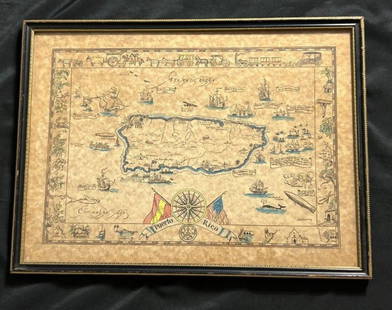
Sold2023Vintage Hand -Colored Pictorial Map of Puerto Rico Circa 1931 by E.B.K. DooleyA vintage hand-colored map of Puerto Rico by E.B.K. Dooley, published c. 1931. This map has a decorative border filled with local plants, wildlife, buildings and transportation. In small scrolls, therSee Sold Price
Sold2024Abraham Ortelius (Belgian 1527 - 1598)Abraham Ortelius (Belgian 1527 - 1598) "Maris Pacifici", circa 1603 Hand Colored map engraving of the Pacific Ocean 14" x 20" Condition: aging, yellowing to paper, undulation, center folds, some fadinSee Sold Price
Sold2024Adam Friedrich Zurner (German 1679 - 1742) and Peter Schenk (German 1660 - 1711)Adam Friedrich Zurner (German 1679 - 1742) and Peter Schenk (German 1660 - 1711) "Americae tam Septentionalis quam Meridionalis in Mappa Geographica Delineato", circa 1709 Hand colored map engraving 2See Sold Price
Sold2015A New Map of the East IndiesTaken from M. de Fer's Map of Asia by Edward Wells (1667-1727), circa 1700, hand-colored map was part of a set of 22 maps dedicated to William, Duke of Gloucester, title cartouche includes the Royal CSee Sold Price
Sold2020Angliae, Scotiae, Et Hiberniae MapCirca 1575; hand colored map of England and Scotland by Abraham Ortelius (1527-1598), 19 x 13 1/2 in., framed.See Sold Price
Sold2023JOOST DE HONDT, HAND COLORED MAP OF CASTILEJoost de Hondt aka Jodocus Hondius the elder (Flemish 1563-1612), "Castiliae Veteris et Novae Descriptio" circa 1620, hand colored map of Castile, unframed. Provenance: From the Estate of C.T. and WilSee Sold Price
Sold2022Antique NEW YORK CITY MAP - FramedAntique New York City Map. 28” x 16” New York City map, circa 1860, hand-colored, double matted and framed to 38 ½” x 26”.See Sold Price
Sold20211725 Hand Colored Map Grand TartarieHand colored map attributed to Affereden's Atlas circa 1725 of Grand Tartarie. Fine, with folds. Measures 7.5 x 7". Reserve: $30.00 Shipping: Domestic: Flat-rate of $6.00 to anywhere within the contigSee Sold Price
2 hrs LeftDoyle New YorkVaugondy's map of Virginia and Maryland, a reduction of Fry and Jefferson's landmark map$600
2 hrs LeftDoyle New YorkA highly detailed map of New England after the Jansson-Visscher series$250(2 bids)
4 days LeftTremont AuctionsJohn Speed and Francis Lamb "Map of New England and New York", ca. 1676. Hand colored engraved map$900(3 bids)
2 days LeftMerrill's Auctioneers and AppraisersFour early 19th c hand colored allegorical Mezzotints$300
3 days LeftTrillium Antique Prints & Rare BooksMitchell's A New Universal Atlas.. - Volume with 73 Maps$1,000(1 bid)
May 14Fleischer's Auctions1755 Map Partie de l'Amerique Septentrionale, qui comprend Le Cours de L'Ohio...$200(3 bids)
May 16Eldred'sHAND-COLORED PRINT OF NANTUCKET, MASSACHUSETTS AFTER WILLIAM MACY Late 19th Century 11" x 31.5"$125


![[MAP - TOURS] (1 of 1)](https://p1.liveauctioneers.com/292/326828/175962850_1_x.jpg?height=282&quality=70&version=1713473479)


