Sold2019Walker, John 1795 Pair of Maps of The Netherlands"The Severn United Provinces" and "Netherlands" Copper Engraved Maps Published 1795, London for "Elements of Geography, and of Natural and Civil History" by John Walker. Centre fold as published. PapeSee Sold Price
Sold20241795 Chart of Jersey and Guernsey, Sark, Herm and Alderney, FadenTitle/Content of Map: 1795 Chart of Jersey and Guernsey, Sark, Herm and Alderney, Faden Date Printed: 1795 Cartographer: William Faden Material/Medium: Engraving Size: 23.5 x 33" Beautiful double-pageSee Sold Price
Sold2021FADEN'S MAP OF GREAT BRITAIN, 1795, FRAMEDFolding Pocket Map, "The Roads of Great Britain" by William Faden, Geographer to the King, 1795, with Supplement for the Roads of Scotland. Linen backed five by four fold, in black frame with gold linSee Sold Price
Sold20231795 Map, Maryland & Delaware [18th c. Cartography]Engraved map of Maryland and Delaware printed in 1799, based on a 1795 edition produced by Samuel Lewis. Drawn by A. Anderson, engraved by J. Scoles. Includes an inset map of the Continuation of the PSee Sold Price
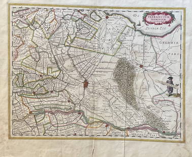
Sold2023The Netherlands Map. The region Around the city of Utrecht. 1660?s by W. BlaeuTitle: The Netherlands Map. The region Around the city of Utrecht. 1660?s by W. Blaeu Date/Period: 1660?s Materials: Hand colored copper plate engraved Size: 22 x 19 1/2'' Netherlands regional map cenSee Sold Price
Sold2019Walker, John 1795 Map of North America. USA CanadaCopper Engraved Map Published 1795, London for "Elements of Geography, and of Natural and Civil History" by John Walker. Centre fold as published. Paper Size: 10 x 8.5 inch (26 x 22cm) Split on centreSee Sold Price
Sold2019Walker, John 1795 Map of IrelandCopper Engraved Map Published 1795, London for "Elements of Geography, and of Natural and Civil History" by John Walker. Centre fold as published. Paper Size: 10 x 8.5 inch (26 x 22cm) Split on centreSee Sold Price
Sold2019Walker, John 1795 Map of The West Indies. CaribbeanCopper Engraved Map Published 1795, London for "Elements of Geography, and of Natural and Civil History" by John Walker. Folds as published. Paper Size: 14.5 x 8.5 inch (37 x 22cm) Minor toning on lefSee Sold Price
Sold2019Walker, John 1795 Map of PolandCopper Engraved Map Published 1795, London for "Elements of Geography, and of Natural and Civil History" by John Walker. Centre fold as published. Paper Size: 10 x 8.5 inch (26 x 22cm) Small split onSee Sold Price
Sold20231795 Map of South American by Mathew Carey, Philadelphia16.5 x 21.5 inches, sight. Framed, 21.5 x 27 inches. Condition reports are not available for the items in this catalog. These are antique and vintage items, and will show signs of use and wear. We havSee Sold Price
Sold2019Walker, John 1795 Map of The World. Twin HemispheresCopper Engraved Map Published 1795, London for "Elements of Geography, and of Natural and Civil History" by John Walker. Folds as published. Paper Size: 14.5 x 8.5 inch (37 x 22cm)See Sold Price
Sold2019Walker, John 1795 Map of Hindoostan or IndiaCopper Engraved Map Published 1795, London for "Elements of Geography, and of Natural and Civil History" by John Walker. Centre fold as published. Paper Size: 10 x 8.5 inch (26 x 22cm) Some toning, moSee Sold Price
Sold2019Robertson & Kitchin 1795 Map. Panama, Ecuador etc"Map of the Countries on the South Sea from Panama to Guayquil" Copper Engraved Map Published 1795, London for "The History of America" by Dr. William Robertson. Drawn & Engraved by Thomas Kitchin. FoSee Sold Price
Sold2019Walker, John 1795 Map of the World on Mercators Proj."General Chart on Mercators Projection" Copper Engraved Map Published 1795, London for "Elements of Geography, and of Natural and Civil History" by John Walker. Centre fold as published. Paper Size: 1See Sold Price
Sold2019Walker, John 1795 Map of ItalyCopper Engraved Map Published 1795, London for "Elements of Geography, and of Natural and Civil History" by John Walker. Centre fold as published. Paper Size: 10 x 8.5 inch (26 x 22cm) Very minor toniSee Sold Price
Sold2019Walker, John 1795 Map of AsiaCopper Engraved Map Published 1795, London for "Elements of Geography, and of Natural and Civil History" by John Walker. Centre fold as published. Paper Size: 10 x 8.5 inch (26 x 22cm) Minor toning alSee Sold Price
Sold2019Walker, John 1795 Map of AfricaCopper Engraved Map Published 1795, London for "Elements of Geography, and of Natural and Civil History" by John Walker. Centre fold as published. Paper Size: 10 x 8.5 inch (26 x 22cm) Very minor toniSee Sold Price
Sold2019Walker, John 1795 Map of Spain and PortugalCopper Engraved Map Published 1795, London for "Elements of Geography, and of Natural and Civil History" by John Walker. Centre fold as published. Paper Size: 10 x 8.5 inch (26 x 22cm) Minor toning onSee Sold Price
Sold2019Walker, John 1795 Map of South AmericaCopper Engraved Map Published 1795, London for "Elements of Geography, and of Natural and Civil History" by John Walker. Centre fold as published. Paper Size: 10 x 8.5 inch (26 x 22cm) Minor toning alSee Sold Price
Sold2019Walker, John 1795 Map of EuropeCopper Engraved Map Published 1795, London for "Elements of Geography, and of Natural and Civil History" by John Walker. Centre fold as published. Paper Size: 10 x 8.5 inch (26 x 22cm) Very minor toniSee Sold Price
Sold2023[ANTIQUE MAP] PARTIE DU NORD DE L'AMERIQUE SEPTENTRIONALE. C.1770s[ANTIQUE MAP] PARTIE DU NORD DE L'AMERIQUE SEPTENTRIONALE. Pour Servir a L'historie Philisophique et Politique... By Rigobert Bonne (1727-1795) Map of the eastern part of North America shows the BritiSee Sold Price
Sold2022Faden Map of the Battle of Hobkirk's Kill, Revolutionary War, 1781FADEN, William (1749 – 1836). Sketch of the Battle of Hobkirks Hill, near Camden on the 25th April, 1781. Engraved map. London: Faden, Aug. 1, 1783. 21 3/4" x 15 1/8" sheet. This RevolutionarySee Sold Price
Sold2022Faden Map of the Plan of the Attack of the Forts Clinton & Montgomery with beautiful original handFADEN, William (1749-1836). Plan of the Attack of the Forts Clinton & Montgomery upon Hudsons River which were Stormed by His Majesty's Forces under the Command of Sir Henry Clinton, 6th of Octr. 1777See Sold Price
Sold2024NICOLAES VISSCHER (NETHERLANDS, 1618-1709) MAP OF THE NEW WORLD"Novi Belgii Novaeque Angliae nec non Partis Virginie Tabula multis in locis emendata", 1656. Handcolored copperplate engraving on two joined sheets of wove paper as issued. Features cartouche panoramSee Sold Price
2 days LeftJasper521647 Jansson Map Central Netherlands -- Ducatus Gelriae pars quarta quae est Arnhemiensis siue$95
2 days LeftJasper521795 Pazzini Carli Map of Southwest England -- Le Provincie Che Sono al Sud Ouest Dell' Inghilterra$60
3 days LeftJasper52The Seven United Provinces… Dutch, Austrian & French Netherlands. BOWEN 1789 map$35
3 days LeftJasper52WORLD WAR 2. Netherlands & Belgium defences. Maginot & Siegfried lines 1940 map$30
3 days LeftJasper52WORLD WAR 2. Netherlands & Belgium defences. Siegfried & Maginot lines 1940 map$35
3 days LeftPotter & Potter AuctionsGEESINK, Joop (1913 – 1984). Europa. 1957. Netherlands: KLM...$100
Featured3 days LeftJasper52Chart of the Sea Coasts of England, Flanders & Holland. MOUNT & PAGE 1758 map$420
3 days LeftJasper52Europe. Royaume des Pays-Bas #13 NW Europe Benelux Germany VANDERMAELEN 1827 map$50
2 days LeftJasper521614 Munster View of Utrecht Netherlands -- Von der Bischofflichen Statt Utrecht$70
5 days LeftTrillium Antique Prints & Rare BooksBraun & Hogenberg, pub. 1575 - View of Dordrecht, Netherlands$100
1 day LeftFleischer's Auctions1755 Map Partie de l'Amerique Septentrionale, qui comprend Le Cours de L'Ohio...$200(3 bids)
6 days LeftBlackstone Valley Auctions & Estates LLCRevolutionary Era War Map of the Attack on Ft. Moultrie.$225(3 bids)
May 21Freeman's | HindmanLeolux 20th Century Pair of Cantilevered Lounge Chairs, c. 1970 Leolux, Netherlands$400


![1795 Map, Maryland & Delaware [18th c. Cartography]: Engraved map of Maryland and Delaware printed in 1799, based on a 1795 edition produced by Samuel Lewis. Drawn by A. Anderson, engraved by J. Scoles. Includes an inset map of the Continuation of the P](https://p1.liveauctioneers.com/7226/275519/144720286_1_x.jpg?height=310&quality=70&version=1673742614)


![[ANTIQUE MAP] PARTIE DU NORD DE L'AMERIQUE SEPTENTRIONALE. C.1770s: [ANTIQUE MAP] PARTIE DU NORD DE L'AMERIQUE SEPTENTRIONALE. Pour Servir a L'historie Philisophique et Politique... By Rigobert Bonne (1727-1795) Map of the eastern part of North America shows the Briti](https://p1.liveauctioneers.com/8321/286473/155024526_1_x.jpg?height=310&quality=70&version=1686787412)


![[COLOR PLATE BOOK]. MUDFORD, William (1782-1848). An Histor... (1 of 5)](https://p1.liveauctioneers.com/928/328184/176813588_1_x.jpg?height=282&quality=70&version=1714496988)


