Sold2019Compleat Map of the British Isles, Or Great Britain andTitle/Content of Map: Compleat Map of the British Isles, Or Great Britain and Ireland With Their Respective Roads And Divisions. Date: 1772 Cartographer: SAYER, ROBERT Publisher: ROBERT SAYER, Size: 2See Sold Price
Sold2017Sayer: Antique Map of Spain & Portugal, 1780Map: Kingdoms of Spain and Portugal, Divided Into Their Great Provinces Publication Date: 1780-03-02 Cartographer: SAYER, ROBERT Publisher: ROBERT SAYER Size: Folio – 18.50 H x 25.25 W Inches ShortSee Sold Price
Sold2017SAMUEL DUNN HAND COLORED PRINTED MAPSAMUEL DUNN, HAND COLORED PRINTED MAP, IMAGE: H 19", W 12 1/2", "A NEW MAP OF THE UNITED STATES OF NORTH AMERICA":"--- with the British Dominions on the continent"; printed for Robert Sayer; framed.See Sold Price
Sold20231762 Accurate Map British Empire North AmericaAn Accurate Map of the British Empire in North America as Settled by the Preliminarues in 1762, by Gibson for Gentleman's Magazine, 1762. Folding map with inset of the entance to the Mississippi. FineSee Sold Price
Sold2024Robert Morden (British, 1650-1703) Map AssortmentRobert Morden (British, 1650-1703) Map Assortment (5) items including (4) by Morden pulled from Gibson's edition of 'Camden's Britannia', first Morden edition, published by Abel Swale and John ChurchiSee Sold Price
Sold2019Attributed to Robert Dixon (British 1780-1815)/FigureAttributed to Robert Dixon (British 1780-1815)/Figure Studies/two chalk sketches on paper, 22.5cm x 31.5cm and 31cm x 17cmSee Sold Price
Sold20222 PC. FRAMED EARLY ENGLISH MAPS2 PC. FRAMED EARLY ENGLISH MAPS: Comprising; 1- Hand-colored Oxford Shire map, by Robert Morden. 1- An accurate map of the county of Bedford divided into its hundreds. Drawn from a late survey, & illuSee Sold Price
Sold2023Lot 2 Antique Colored Maps 1780's Janvier British Isles & Abujettie EuropeLot 2 Antique Colored Maps including 1780' British Isles by s Janvier and Europe by Abujettie of similar age. Both are colored etchings.. Measurements in inches: 16 x 12 and 19 x 15 Condition:Has wearSee Sold Price
Sold2019Gilles Robert de Vaugondy (1688-1766), "An Accurate MapGilles Robert de Vaugondy (1688-1766), "An Accurate Map of North America," matted, c. 1760, hand colored, H.- 8 in., W.- 12 in.See Sold Price
Sold2022JEFFERYS, THOMAS The Coast of West Florida and Louisiana/ The Peninsula and Gulf of Florida orJEFFERYS, THOMAS The Coast of West Florida and Louisiana/ The Peninsula and Gulf of Florida or Channel of Bahama with the Bahama Islands. London: Robert Sayer, 20 February 1775. Engraved map on joinedSee Sold Price
Sold2016THOMAS KITCHIN (ENGLAND 1718-1784), "A NEW AND ACCURATETHOMAS KITCHIN (ENGLAND 1718-1784), "A NEW AND ACCURATE MAP OF THE BRITISH DOMINIONS IN AMERICA, ACCORDING TO THE TREATY OF 1763; DIVIDED INTO THE SEVERAL PROVINCES AND JURISDICTIONS", C.1765. SIGHT 2See Sold Price
Sold20211762 Map of the British Empire in North AmericaHistoric Maps 1762 Map, "An Accurate Map of the British Empire in Nth America as settled by the Preliminaries in 1762" 1762 French and Indian War Period Map titled, "An Accurate Map of the British EmpSee Sold Price
Sold2015Africa According to Mr. D'Anvillewith Several Additions and Improvements, London: Printed for Robert Sayer, 1772, a four-sheet map of Africa, hand-colored in outline with a large decorative title cartouche, a sea chart of the Gold CoSee Sold Price
Sold2022After Sir Robert Smirke R.A. (British, 1780-1867), Two Engravings for Boydell's "Shakspeare Gallery"After Sir Robert Smirke R.A. (British, 1780-1867), Two Engravings for Boydell's "Shakspeare Gallery"the first from King Henry the Fourth, Part 1, Act II, Scene 4, engraved by Robert Thew, published 17See Sold Price
Sold2017Emanuel Bowen, map Eastern SeaboardEmanuel Bowen, map Eastern Seaboard, Emanuel Bowen (British, 1694-1767), "A New and Accurate Map of New Jersey, Pennsylvania, New York, and New England", c. 1744, from Maryland to Nova Scotia, hand-coSee Sold Price
Sold2022Emanuel Bowen Map USA Eastern Seaboard 1740s New YorkEmanuel Bowen, map of United States Eastern Seaboard, Emanuel Bowen (British, 1694-1767), "A New and Accurate Map of New Jersey, Pennsylvania, New York, and New England", c. 1744, from Maryland to NovSee Sold Price
Sold2018New Map of the Kingdom of Poland With Its DismemberedReserve Reduced! Title: New Map of the Kingdom of Poland With Its Dismembered Provinces. Date: 1787-01-01Publisher: ROBERT SAYER, Size (inches): 21.25X28.75 Map 20 from Sayer's General Atlas of 1790.See Sold Price
Sold2022ROBERT BRICHET (BRITISH, ACTIVE 1780-1790), AFTER JOSEPH FRANZ VON GOZ, HANDCOLORED ENGRAVINGS ONROBERT BRICHET (BRITISH, ACTIVE 1780-1790), AFTER JOSEPH FRANZ VON GOZ, HANDCOLORED ENGRAVINGS ON PAPER, 2 PCS., H 7-9.75" W 4.75-6.625", "SOMER UND WINTER" AND "LE SANGUIN" Each having Birds-eye MaplSee Sold Price
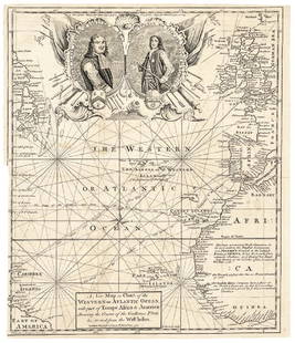
Sold20171740 Ornate Copperplate Engraved Portrait MapHistoric Maps 1740 Ornate Copperplate Engraved Map with Portraits of British Admirals “Robert Blake” & “Edward Vernon, Esq.” 1740-Dated, Copperplate Engraved Map titled “A New Map or Chart oSee Sold Price
Sold2019Map of South AmericaTitle/Content of Map: Map of South America Date: 1775-09-20 Cartographer: ANVILLE, JEAN BAPTISTE BOURGUIGNON D' (1697-1782) | ROBERT SAYER Publisher: ROBERT SAYER, Size: 39.25Height - 46.6Width quiteSee Sold Price
Sold2024Henry Morland (British, 1716-1797), A Connoisseur and Tired BoyHenry Morland (British, 1716-1797), A Connoisseur and Tired Boymezzotint, printed 1773, engraved by Philip Dawe, published in London, printed for Robert Sayer, framed. Platemark 19 3/8 x 13 15/16 in.;See Sold Price
Sold2023After Lieutenant John Ross (British, 1744-1809), "Course of the River Mississippi [sic], from theAfter Lieutenant John Ross (British, 1744-1809), "Course of the River Mississippi [sic], from the Balise to Fort Chartres...," 1775, engraved and published with hand-colored outlines by Robert Sayer aSee Sold Price
Sold2023Map of Connecticut And Rhode Island 1780This early map is titled 'A New and accurate Map of Connecticut and Rhode Island. from the best Authorities' published in the Universal Magazine in 1780. The map features Long Island Sound and NarragaSee Sold Price
Sold2018Ireland - Roque, John 1762 Large Rare Wall Map"A Map of the Kingdom of Ireland Divided into Provinces, Counties and Baronies" Large Copper Engraved Map with original hand colour. Published 1762 by Robert Sayer. 4 Joined Sheets to form one large mSee Sold Price
2 days LeftLUXUR Fine Art AuctionAfter Robert Sayer (1725-1794, English Map Publisher) Print 'Hudibras First Adventure'$10
5 days LeftJasper521794 Laurie and Whittle Map of the Russian Empire -- The European Part of the Russian Empire ... /$600
6 days LeftJasper52Fine Victorian Oil Painting, Milk Maid & Dog Walking Through Wooded Valley c. 1850's$2,400
5 days LeftJasper52The rendez-vous of the barges upon the Meuse. After F.E. Weirotter. W. Basnett (c.1770-c.1790)$150
May 05Tremont Auctions18th century map of New Jersey. "A New and Accurate Map of New Jersey". W. Long, London. Map size 13$100
May 11Crescent City Auction GalleryCharles Robert Leslie (British, 1794-1859), "Family Portrait in a Parlor, possibly the Gardiner$250(1 bid)
3 days LeftGreat Estates Auctioneers & Appraisers1850 ROBERT HORNER MAP OF NEW JERSEY & ADJOINING$125(2 bids)
May 09Freeman's | HindmanRobert William Wood (British/American, 1889-1979) Texas Landscape$2,000(1 bid)
6 days LeftDoyle New YorkVaugondy's map of Virginia and Maryland, a reduction of Fry and Jefferson's landmark map$600
May 04BucklinPenn, Irving; Moments Preserved [SIGNED TO OSCAR WINNER ROBERT BOLT] doctor zhivago$60(2 bids)


![After Lieutenant John Ross (British, 1744-1809), "Course of the River Mississippi [sic], from the: After Lieutenant John Ross (British, 1744-1809), "Course of the River Mississippi [sic], from the Balise to Fort Chartres...," 1775, engraved and published with hand-colored outlines by Robert Sayer a](https://p1.liveauctioneers.com/328/305751/163451640_1_x.jpg?height=310&quality=70&version=1697494776)


![Penn, Irving; Moments Preserved [SIGNED TO OSCAR WINNER ROBERT BOLT] doctor zhivago (1 of 5)](https://p1.liveauctioneers.com/8658/325945/175539767_1_x.jpg?height=282&quality=70&version=1712964944)