Sold2017Buache: Antique Map of New York, Long Island, 1807Map: Ile de New-York Partie de Long-Island ou de l'Ile Longue et positions des armées Américaine et Britannique après le combat livré sur les hauteurs, le 27 Août, 1776. Maker: Buache, Jean NicolSee Sold Price
Sold2024(45)1930s-50s Road Maps, Railroad,More - 1944 New York Central & Long Island Railroad Time Tables,(45)1930s-50s Road Maps, Railroad,More - 1944 New York Central & Long Island Railroad Time Tables, Maps - NY, Ohio, Kentucky, Tennessee, Indiana, Kansas, New Jersey + MoreSee Sold Price
Sold2023Dripps' Map of the Five Cities New York, Brooklyn, Long Island City 19th Century folding pocket mapA rare and scarce folding pocket map showing a "MAP OF THE CITIES OF NEW YORK, BROOKLYN, LONGISLAND CITY, JERSEY CITY & HOBOKEN" published by "M. DRIPPS, 103 FULTON ST. N. Y." with a catalogue of M. DSee Sold Price
Sold2023Map: United States– East Coast / Connecticut– New York/ Long Island Western PartDescription: United States– East Coast / Connecticut– New York/ Long Island Western Part. Published at Washington D.C. US Department of Commerce, National Oceanic Service. Measurement apSee Sold Price
Sold2023MAP: United States - East Coast. Connecticut - New York. Long Island Sound - Eastern PartDescription: United States - East Coast. . Connecticut - New York. Long Island Sound - Eastern Part. Published at Washington D.C. US Department of Commerce, Environmental Science services AdministratiSee Sold Price
Sold2023JOHN LEE BALDWINGroup of (4) duck carvings mounted on a piece of cedar clapboard, by JOHN LEE BALDWIN (American, Babylon, Long Island, New York, 1868-1938). The interesting fact is that three of the four are mallardsSee Sold Price
Sold20231902 Cram Map of Long Island -- Map of Long Island New YorkTitle: 1902 Cram Map of Long Island -- Map of Long Island New York Cartographer: G Cram Year/Place: 1902, Chicago Dimensions: 9.8 X 12.4 in. Description: This is an attractive map of Long island withSee Sold Price
Sold20211897 Map of Long IslandTitle: 1897 Map of Long Island Author: Cram Medium: Ink on Paper Dimensions: 14.5"X11.5" Description: Map of Long Island, New York dated 1897. Printed and engraved by George Cram in Chicago. Key lowerSee Sold Price
Sold2021Nautical Map / Sea Chart, #362 Block Island Sound andDescription: Nautical Map / Sea Chart, United States East Coast, New York, Long Island, Block Island Sound and Gardiner's Bay, 6th edition, Feb 10/69; Shipping: $20; different rate to California, AlasSee Sold Price
Sold2020Nautical Map / Sea Chart, #1212 Eastern Long IslandDescription: Nautical Map / Sea Chart, United States East Coast, Connecticut - New York, Long Island Sound, Eastern Part, 12th edition feb 10 / 69 ; all measurements are approximate; Folded; ShippingSee Sold Price
Sold2022Engraved Map of Battle of Long Island 1776Map (Paris: Dentu, 1807) - "Ile de New-York Partie de Long-Island ou de l'Ile Longue et positions des armées Américaine et Britannique après le combat livré sur les hauteurs, le 27 AoûtSee Sold Price
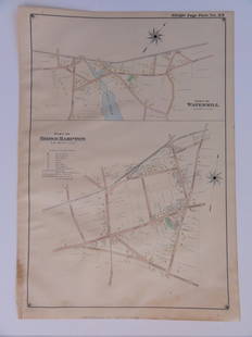
Sold2016Bridgehampton & Watermill, Long Island, 1902Original engraving published by E. Belcher Hyde from "Atlas of Suffolk County, Long Island, New York," Philadelphia, 1902. Map features family names, historic buildings and railroad routes. DimensionsSee Sold Price
Sold2023Sketch of the Country...Long Island.[Map/New York] Sketch of the Country Illustrating the Late Engagement in Long Island, from The Gentleman's Magazine, London, 1776. Handcolored copperplate engraving. Published in October 1776, of thisSee Sold Price
Sold20181807 Marshall Map Showing New York City in 1776 -- IleTitle/Content of Map: 1807 Marshall Map Showing New York City in 1776 -- Ile de New-York. Partie de Long-Island ou de l'Ile Longue, et Positions des Armees Americaine et Britannique, apres le Combat LSee Sold Price
Sold2016MAP OF NEW YORK, THOMAS KITCHIN, 1756A MAP OF THE EASTERN PART OF THE PROVINCE OF NEW YORK, WITH PART OF NEW JERSEY, showing Pennsylvania, New York state, Long Island, Connecticut and New Hampshire, with Lake OntarioSee Sold Price
Sold2021MAP OF NEW YORK PERTAINING TO THE REVOLUTIONARY WARMAP OF NEW YORK PERTAINING TO THE REVOLUTIONARY WAR BATTLE OF BROOKLYN HEIGHTS"A Plan of New York Island, part of Long Island &c. shewing the Position of the American and British Armies, before,See Sold Price
Sold20231852 Map of New York City1852 map "Plan of the City of NY," copy of D. Longwerth's Map of 1808 for D.T. Valentine's Manuel for 1852. Includes North or Hudson River, Port of Nassau of Long Island. Encompasses 1-10 wards. LithoSee Sold Price
Sold20191832 Marshall Revolutionary War Map of New York City --Title/Content of Map: 1832 Marshall Revolutionary War Map of New York City -- Plan of New York Island and Part of Long Island Shewing the Position of the American & British Armies before, at, and afteSee Sold Price
Sold2023MAP: United States - East Coast. Thames River New York London Harbor Long Island to NorwichDescription: United States - East Coast Connecticut - New York. Thames River/ New York London Harbor Long Island to Norwich. Published at Washington D.C. US Department of Commerce, Environmental ScienSee Sold Price
Sold2017FW Falls Long Island NY Yard Long ChromolithographUNITED STATES, EARLY 20TH CENTURY A yard long chromolithograph of Long Island, New York after F.W Falls. The map illustrates the topography of Long Island, Manhattan, and Montauk giving a representatiSee Sold Price
Sold2016Town of Southampton Map (North Haven & Art Village),Original engraving of Southhampton town, including Peconic Bay, Hobson Island and many landmarks & family names. Published by E. Belcher Hyde from "Atlas of Suffolk County, Long Island, New York," 190See Sold Price
Sold2023E. Belcher Hyde Map Co. - Maps of Suffolk, Group of 4Lot 49 E. Belcher Hyde Map Co. American Manufacturer (fl. c. 1880 - 1920) Maps of Suffolk, Group of 4 (1916) lithograph with hand coloring from Suffolk County 1916 Vol 2 Long Island, New York, includeSee Sold Price
Sold20181776 Map of Country Round Philadelphia New JerseyA Map of the Country round Philadelphia including Part of New Jersey New York, Staten Island and Long Island, published for Gentleman's Magazine, London, 1776. Fine condition, folds as issued, measureSee Sold Price
Sold2023E. Belcher Hyde Map Co. - Maps of Sag Harbor, Group of 2Lot 48 E. Belcher Hyde Map Co. American Manufacturer (fl. c. 1880 - 1920) Maps of Sag Harbor, Group of 2 (1916) lithograph with hand coloring from Suffolk County 1916 Vol 2 Long Island, New York 17 xSee Sold Price
2 days LeftJasper521867 Beers Map of New York City Area -- Map of New York and Vicinity Accompanying "Atlas of New York$200
15 hrs LeftFederal Assets AuctioneersThere's Music: New Jersey, New York, Long Island Too!! by Fazzino, Charles$225(2 bids)
Jul 02Robinhood AuctionsCharles Fazzino, "There's Music: New Jersey, New York, Long Island Too!!" Framed 3D Limited Edition$1,000
15 hrs LeftSeized Assets AuctioneersThere's Music: New Jersey, New York, Long Island Too!! by Fazzino, Charles$1
3 days LeftSeized Assets AuctioneersThere's Music: New Jersey, New York, Long Island Too!! by Fazzino, Charles$1
4 days LeftSeized Assets AuctioneersThere's Music: New Jersey, New York, Long Island Too!! by Fazzino, Charles$1
Jun 30Robinhood AuctionsCharles Fazzino- 3D Construction Silkscreen Serigraph "There's Music... New Jersey, New York, Long$800
51 mins LeftRobinhood AuctionsCharles Fazzino- 3D Construction Silkscreen Serigraph "There's Music: New Jersey, New York, Long$1,100
Jul 04Robinhood AuctionsCharles Fazzino- 3D Construction Silkscreen Serigraph "There's Music: New Jersey, New York, Long$1,100
496 Lots AwayWhite Knight Auction, IncFrida Kahlo, With Diego Rivera At Jones Beach State Park, Long Island, New York, 1933$100(1 bid)
51 mins LeftEast Coast Fine Arts LLCShepard Alonzo 1852 Mount Setauket Long Island NY Landscape$4,000
BonhamsA Plains beaded strike-a-lite pouch size of pouch including tin cones 7 x 4 1/2, lg. including d...$400
BonhamsTwo Southern Plains beaded awl cases and a pouch lg. including drops 13 1/2, 10, and 9 x 3 1/2 in.$400


![Sketch of the Country...Long Island.: [Map/New York] Sketch of the Country Illustrating the Late Engagement in Long Island, from The Gentleman's Magazine, London, 1776. Handcolored copperplate engraving. Published in October 1776, of this](https://p1.liveauctioneers.com/179/305680/163721131_1_x.jpg?height=310&quality=70&version=1697214016)


