Sold2024Map Of Northern Scotland By Gerard MercatorScoti Ae Regnvm, Site 14.25" x 18.25"See Sold Price
Sold2016Mercator map of northern ScotlandHeading: Author: Mercator, Gerard Title: Scotiae Regnum Place Published: Antwerp Publisher: Date Published: c.1610 Description: Copper-engraved map, hand-colored. 35x45.5 cSee Sold Price
Sold2022Seventeenth Century Map of Northern ScotlandHand colored map titled "Is DE FARO DE SCHELAND ORKNAY ET HEBRIDES" by French cartographer Mallet Alain, Paris, 1683. Framed map measures 5.5" x 4" (sight) and shows northern Scotland as well as the HSee Sold Price
Sold2024MAP, Scotland, BlaeuNorthern Scotland. Johannes Blaeu, Cathenesia. Caithness, from Geographiae Blavianae Volumen Sextum, 1662 (published). Hand Color. This beautifully engraved map covers the northern tip of Scotland. ThSee Sold Price
Sold2023Ptolemy, Fries, pub. 1535 - Map of Northern Africa and EgyptThis important historic map is from Geographicae enarrationis libri octo Ex Bilibaldi Pirckeymheri tralatione, fed ad Graeca & prisca exemplaria.... The work was published in 1535 in Lyon after LorenzSee Sold Price
Sold2022PERRIER Vintage Motor Map of Scotland XLPERRIER Vntg Motor Map of Scotland, measures approx 42 x 48 inches. Wear to map. Artwork, Home Decor, Wall Art, Educational Map, Topography. Art Print, Map Print, antique map, collectible antique map,See Sold Price
Sold2022Antique Map Print - Ireland - England - Wales - ScotlandSet of 4 Map Prints. Antique lithographic map originates from "Letts's Popular Atlas", being a series of maps delineating the whole surface of the globe, with many special and original features; and aSee Sold Price
Sold2022MID CENTURY POLISH PUBLICATIONS AND WW2 POSTERSA lot of mid-century Polish wall prints and publications. A total of 17 items including 13 color reprints of World War II posters, three 1960s maps of northern Poland, and a September 10, 1927 issue oSee Sold Price
Sold2022MID CENTURY POLISH PUBLICATIONS AND WWII POSTERSA lot of mid-century Polish wall prints and publications. A total of 17 items including 13 color reprints of World War II posters, three 1960s maps of northern Poland, and a September 10, 1927 issue oSee Sold Price
Sold2018Set 2 Art Prints of Vintage MapsSet of two gold toned framed Art Prints of Vintage Maps. One world map and one map of the northern section of South America. Both pieces labeled in print as being ‘Appendix 10 - Coast and Geodetic SSee Sold Price
Sold2017Moll maps of England and ScotlandHeading: Author: Moll, Herman Title: Two maps, of the northern and southern parts of Great Britain Place Published: London Publisher: Date Published: 1710-1714 Description:See Sold Price
Sold2018Set of 2 Framed Prints of Antique MapsSet of 2 Framed Antique Maps - Small map of England and Scotland. Large Map of the Mediterranean with ships. Measures approx. Large map 28" tall x 31" w x 1" deep. Small map 12" tall x 15" w x 3/4" deSee Sold Price
Sold2022Kelly, Christopher 1836 Antique Print. Edinburgh, ScotlandCopper Plate Published 1836, London for "A New and Complete System of Universal Geography" by Christopher Kelly. Maps Engraved by Findlay, Wallis and others. Paper Size: 10.5 x 8 inch (27 x 20cm) GoodSee Sold Price
Sold2022Kelly, Christopher 1836 Antique Print. Glasgow, ScotlandCopper Plate Published 1836, London for "A New and Complete System of Universal Geography" by Christopher Kelly. Maps Engraved by Findlay, Wallis and others. Paper Size: 10.5 x 8 inch (27 x 20cm) GoodSee Sold Price
Sold2024Ptolemy & Magini, pub. 1620 - Map of the British Isles (England, Scotland, Ireland) / Verso: Map ofThis early map engraving is from Claudius Ptolemaeus (Ptolemy) and Giovanni Antonio Magini's Geografia cio? Descrittione Universale della Terra Partita in due volumni, Nel Primo de' quali si contengonSee Sold Price
Sold2020Rapkin, John 1860 Lot of 5 British & European MapsIncl Scotland, Germany, England/Wales, Denmark and Northern Italy. Steel Engraved Maps Published 1860 by The London Printing & Published Company, London for "The Royal Dictionary-Cyclopedia for UniverSee Sold Price
Sold2022A late 18th century map sampler depicting southern Scotland, England and WalesA late 18th century map sampler depicting southern Scotland, England and Wales Also including the east coast of Ireland and northern France, worked on a linen group and signed and inscribed 'Wrought iSee Sold Price
Sold2021NORTHERN TRUST COMPANY ADVERTISING EPHEMERA AND OTHERNORTHERN TRUST COMPANY ADVERTISING EPHEMERA AND OTHER ARTICLES, UNCOUNTED LOT, more than 30 pieces, including a framed colored lithograph print featuring a map of Illinois surrounded by various vignetSee Sold Price
Sold2018Oversized Industrial Commercial Oak Map Print CheOversized Industrial Commercial Oak Map Print Chest. Metal handles, panel sides. Antique.-- Dimensions: H: 65.5 inches: W: 63 inches: D: 25 inches ---See Sold Price
Sold2017German Moscovia Map PrintTitled "Mosvavw", hand colored, note on verso "Braun and Hogenburg, Cologne c. 1585 The earliest obtainable map or view of Moscow". Map, 15-1/2" x 21", framed 22-1/2" x 28"See Sold Price
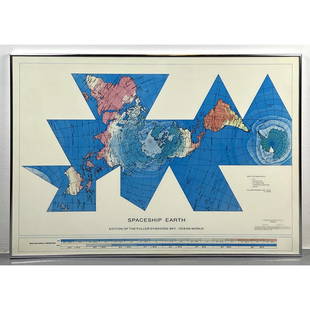
Sold2023Richard Buckminster Fuller Dymaxion World Map Print, 1980 FullerRichard Buckminster Fuller Dymaxion World Map Print, 1980 Fuller Dimensions: H: 22.5 inches: W: 34.5 inches --- -- We offer curbside delivery to NYC, Manhattan, Close Brooklyn, Hoboken about a week afSee Sold Price
Sold2020Norddeutscher Lloyd Bremen Ocean Liner Map PrintNorddeutscher Lloyd Bremen Ocean Liner Map Print framed under ship with steamships Munchen and Columbus. Measurements in inches: 45 x 33, Image: 39 x 27 Condition:Some wear to frame, print is clean ShSee Sold Price
Sold201819C Oak Map Print Paper Collector's Case CabinetUnited States,Late 19th Century Six long drawers with bin pulls on a molded base, used for holding works on paper including maps and blueprints. Oak 57" x 36" x 32", From an Exeter, Rhode Island estatSee Sold Price
Sold20193pc Stacking Industrial Metal Map Print Cabinet.3pc Stacking Industrial Metal Map Print Cabinet. Gray metal 5 drawer sections. Some drawers are lined. Silver chrome pulls. Marked HAMILTON.-- Dimensions: H: 49.75 inches: W: 41 inches: D: 29.5 inchesSee Sold Price
6 days LeftJasper52Northern Ayrshire. Troon Irvine Ardrossan Kilmarnock Prestwick. THOMSON 1832 map$360
6 days LeftJasper52Hyperboreorum/Septentrionalum regionum. Bertius/Langenes. Europe Arctic 1603 map$420
4 days LeftWinter Associates Three historical engraved maps of the Caribbean, ranging from 1616-1814, each hand colored, framed$100(1 bid)
6 days LeftJasper52A New and Correct Chart of England, Scotland and Ireland. MOUNT & PAGE 1758 map$260
1 day LeftRapid Estate Liquidators and Auction GalleryVintage Framed Cat Island Nautical Map Print$55
6 days LeftForum AuctionsGeology of the British Isles.- Geikie (Sir Archibald) Geological Map of England & Wales [together£100
6 days LeftJasper52London in 1897 with street improvements since 1855. 80x105 cm. Edwards 1898 map$260
6 days LeftJasper52Africae / Africa by Bertius / Langenes 1603 old antique vintage map plan chart$260