Sold2020Rapkin, John 1860 Lot of 5 British & European MapsIncl Scotland, Germany, England/Wales, Denmark and Northern Italy. Steel Engraved Maps Published 1860 by The London Printing & Published Company, London for "The Royal Dictionary-Cyclopedia for UniverSee Sold Price
Sold2020Rapkin, John 1860 Lot of 5 European MapsIncl Belgium, Switzerland, Denmark, Turkey in Europe, and Sweden/Norway. Steel Engraved Maps Published 1860 by The London Printing & Published Company, London for "The Royal Dictionary-Cyclopedia forSee Sold Price
Sold2023Rapkin, John 1860 Lot of 3 British MapsIncl Channel Islands, England/Wales and Scotland. Steel Engraved Map Published 1860 by The London Printing & Published Company, London for "The Royal Dictionary-Cyclopedia for Universal Reference" bySee Sold Price
Sold2020Rapkin, John 1860 Lot of 6 European MapsIncl Greece, Turkey in Europe, Switzerland, Spain/Portugal, Sweden/Norway, and Russia in Europe. Steel Engraved Map Published 1860 by The London Printing & Published Company, London for "The Royal DicSee Sold Price
Sold2023Rapkin, John 1860 Mixed Lot of 4 European MapsIncl Europe Continent, Southern Italy, Belgium and Switzerland. Steel Engraved Map Published 1860 by The London Printing & Published Company, London for "The Royal Dictionary-Cyclopedia for UniversalSee Sold Price
Sold2022Rapkin, John 1860 Lot of 14 Antique MapsIncl Turkey in Europe, Switzerland, Sweden/Norway, British Isles, Southern Italy, Asia Minor, Belgium, Channel Islands, Denmark, Europe, England/Wales, Egypt, Greece and Russia in Europe. Steel EngravSee Sold Price
Sold2021Bartholomew, John 1904 Lot of 5 British MapsIncl Height of Land/Depth of Sea, Prevailing Vegeation, Principal Highroads, Lighthouses, and Counties. Lithograph Maps Published 1904, London for "The Survey Gazetteer of the British Isles" UncommonSee Sold Price
Sold2021Bartholomew, John 1904 Lot of 5 British Climate MapsIncl River Basins/Tidal Flow, Mean Annual Rainfall, January/July Temp., Actual Temperature, and January/July Rainfall. Lithograph Map Published 1904, London for "The Survey Gazetteer of the British IsSee Sold Price
Sold2022Dugdale & Archer C1840 Lot of 5 British County MapsSteel Engraved Maps with outline hand color Published C1835-60 London for "Curiosities of Great Britain. England & Wales Delineated..." by Thomas Dugdale. Drawn and Engraved by John Archer. Paper SizeSee Sold Price
Sold2020Rapkin, John 1860 Map of India"British India" Steel Engraved Map Published 1860 by The London Printing & Published Company, London for "The Royal Dictionary-Cyclopedia for Universal Reference" by Thomas Wright. Drawn & Engraved bySee Sold Price
Sold2021Bartholomew, John 1889 Lot of 5 World, Europe MapsIncl Natural Productions, Chart of the World of showing Heights and Depths, Sketch Chart of the North Atlantic, Railway Map of Central Europe, and Railway Map of British Isles. Lithograph Maps PublishSee Sold Price
Sold2022Aiken, John 1795 Lot of 10 British Maps. Manchester & North WestCopper Plate Published 1795, London for "A Description of the Country from Thirty to Forty Miles Round Manchester" by John Aiken. Paper Size: 11.5 x 9 inch (29 x 23cm) Some toning present, a couple wiSee Sold Price
Sold2020Bartholomew, John 1922 Lot of 12 European MapsOne Map of Asia continent and the others of European Countries. Incl British Isles, Belgium/Holland, Spain/Portugal, North Italy/Austria, Greece, South Italy, Central European States, and Germany SoutSee Sold Price
Sold2019Bartholomew, John 1922 Lot 5 Maps of Britain & IrelandIncl British Isles Political, British Isles Railways, Scotland South, Scotland North, Ireland North Section, Ireland Southern Section. Large Lithograph Maps Published 1922 by The Times, London for "ThSee Sold Price
Sold2022India 1860-1890's Lot of 3 Antique MapsSteel Engraved Map Published 1860 by The London Printing & Published Company, London for "The Royal Dictionary-Cyclopedia for Universal Reference" by Thomas Wright. Drawn & Engraved by John Rapkin. FoSee Sold Price
Sold2019Cornwell & Dower 1849 Lot of 6 European MapsIncl Germany, Austria, Europe, Spain/Portugal, Prussia, and France. Steel Engraved Maps Published 1849, London for "A School Atlas" by James Cornwell. Maps by John Dower. Paper Size: 6.5 x 4 inch (16See Sold Price
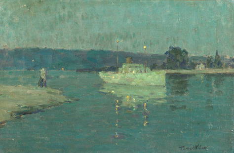
Sold2021Terrick John Williams, RA (British, 1860-1936)Terrick John Williams, RA (British, 1860-1936) The white ship, Seine signed 'Terrick Williams' (lower right); signed and titled (on the reverse) oil on canvas 27 x 40.7cm (10 5/8 x 16in). This lot isSee Sold Price
Sold2017John Rapkin, (2) maps North and South AmericaJohn Rapkin, (2) maps North and South America, John Rapkin (British, 1815-1876), "North America" and "South America", c. 1851, hand-colored engraved maps with decorative border and vignettes, 14.5"h xSee Sold Price
Sold2020Rapkin, John 1860 Map. World HemispheresSteel Engraved Map Published 1860 by The London Printing & Published Company, London for "The Royal Dictionary-Cyclopedia for Universal Reference" by Thomas Wright. Drawn & Engraved by John Rapkin. FoSee Sold Price
Sold2022Rapkin, John 1860 Map. World on Mercators ProjectionSteel Engraved Map Published 1860 by The London Printing & Published Company, London for "The Royal Dictionary-Cyclopedia for Universal Reference" by Thomas Wright. Drawn & Engraved by John Rapkin. FoSee Sold Price
Sold2020Rapkin, John 1860 Map. World on Mercator's ProjectionSteel Engraved Map Published 1860 by The London Printing & Published Company, London for "The Royal Dictionary-Cyclopedia for Universal Reference" by Thomas Wright. Drawn & Engraved by John Rapkin. FoSee Sold Price
Sold2019Rapkin, John 1860 Map of the World HemispheresSteel Engraved Map Published 1860 by The London Printing & Published Company, London for "The Royal Dictionary-Cyclopedia for Universal Reference" by Thomas Wright. Drawn & Engraved by John Rapkin. FoSee Sold Price
Sold2020Rapkin, John 1860 Map. World on Mercator's ProjectionSteel Engraved Map Published 1860 by The London Printing & Published Company, London for "The Royal Dictionary-Cyclopedia for Universal Reference" by Thomas Wright. Drawn & Engraved by John Rapkin. FoSee Sold Price
Sold2022Butler, Samuel 1842 Lot of 5 European MapsIncl Germany/Prussia, North Italy/Switzerland, Russia, Denmark/Sweden/Norway, and Holland/Belgium. Steel Engraved Map Published 1842, London for "An Atlas of Modern Geography" by Samuel Butler. DrawnSee Sold Price
5 days LeftJasper52JAMAICA. Counties/parishes. Sugar Mill & Kingston views. RAPKIN/TALLIS 1851 map$85
5 days LeftJasper52JAMAICA. Counties/parishes. Sugar Mill & Kingston views. RAPKIN/TALLIS 1851 map$85
5 days LeftJasper52WEST INDIA ISLANDS'. Caribbean Indies Antilles Bahamas. TALLIS/RAPKIN 1851 map$120
May 15BonhamsGeorge Leslie Hunter (British, 1877-1931) Still life with roses in a Chinese blue and white jar ...£32,000
May 16Freeman's | HindmanJohn Frederick Herring the Elder (British, 1795-1865) Lottery Going to the Start at Doncaster, 1830$40,000
May 16Freeman's | HindmanJohn Frederick Herring the Elder (British, 1795-1865) Memnon, a Bright Bay, William Scott up,$35,000
May 15BonhamsJohn Bellany CBE RA HRSA LLD(Lon) (British, 1942-2013) Still life of flowers in a blue vase unfr...£2,500
May 15BonhamsJohn Bellany CBE RA HRSA LLD(Lon) (British, 1942-2013) Still Waters of Eyemouth in harbour unframed£3,200
May 15BonhamsJohn Byrne (British, 1940-2023) 'Beachboy with Cat & Fish' plate 27.5 x 20cm (10 13/16 x 7 7/8in...£400
May 15BonhamsJohn Duncan Fergusson RBA (British, 1874-1961) A couple in a Paris café, c. 1909£480