Sold2015(FORT SULLIVAN)(FORT SULLIVAN) Scarce Revolutionary War A.D.S., 1p. 12mo., Fort Sullivan, South Carolina, Oct. 26, 1776, an order that the bearer be given: "...Five Gills Rum for Men on Fatigue...". Likely cut fromSee Sold Price
Sold2017Revolutionary War MapMap, 18” x 11,” “Plan of the Siege of Charleston in S. Carolina" 1807, publishedC.P. Wayne, Philadelphia, withdrawn from book. Showing the location of downtown Charleston, Fort Sullivan (later nSee Sold Price
Sold2023Map of 1776 New York and New JerseyLot 102 Map of 1776 New York and New Jersey compiled from the surveys of William Tryon Efq. by Claude Joseph Sauthier, originally engraved by William Faden 29 1/2 x 23 1/4 inches frame dimensions: 39See Sold Price
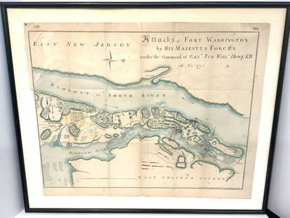
Sold2021Map Of Attacks Of Fort Washington 16th, November 1776.D.T. Valentine's Manual Of 1861, Map Of Attacks Of Fort Washington by His Majesty's forces under the command of General Sir Will Howe K.B. 16th of November 1776 (Revolutionary War) .. Hand colored. MaSee Sold Price
Sold2016Map, Hudson River, Rev. War, Sauthier, 1776At the top of the map is written: "A Topographical Map of Hudsons River, with the Channels Depth of Water, Rocks, Shoals, &c. and the Country Adjacent, from Sandy-Hook, New York and Bay to Fort EdwardSee Sold Price
Sold2022A Plan of Charles Town the Capital of South Carolina… Charleston. LODGE 1780 mapTITLE/CONTENT OF MAP: 'A Plan of Charles Town the Capital of South Carolina, with the Harbour, Islands and Forts; the Attack on Fort Sulivan, by His Majesty's Ships under Sir Peter Parker, in 1776; thSee Sold Price
Sold2022Faden Map of the Plan of the Attack of the Forts Clinton & Montgomery with beautiful original handFADEN, William (1749-1836). Plan of the Attack of the Forts Clinton & Montgomery upon Hudsons River which were Stormed by His Majesty's Forces under the Command of Sir Henry Clinton, 6th of Octr. 1777See Sold Price
Sold2022Faden Map of the Battle of Hobkirk's Kill, Revolutionary War, 1781FADEN, William (1749 – 1836). Sketch of the Battle of Hobkirks Hill, near Camden on the 25th April, 1781. Engraved map. London: Faden, Aug. 1, 1783. 21 3/4" x 15 1/8" sheet. This RevolutionarySee Sold Price
Sold2018Beautiful Antique Charleston SC MapReplete with all streets, public buildings legend, rivers, surrounding tributaries etc. Good frame measures 27 x 21 inches.See Sold Price
Sold20221776 Santini's Map of Canada and the NortheastHistoric Maps 1776 Map, PARTIE ORIENTALE DU CANADA, AVEC LA NOUVELLE ANGLETERRE, L'ACADIE, ET LA TERRE-NUEVE, by P. Santini 1776-Dated First Edition, Hand-Colored Map, PARTIE ORIENTALE DU CANADA, AVECSee Sold Price
Sold2017William Faden 1796 Map Eastern US, North AmericaFaden, William (BRITISH, 1749-1836); Map of the Eastern United States, North American with British Territories and Those of Spain according to the Treaty of 1784 (from a larger atlas), 1796; handcolorSee Sold Price
Sold2021Course of the River Mississipi [sic]"Course of the River Mississipi [sic], from the Balise to Fort Chartres..." map by Lieutenant John Ross of the 34th Regiment, engraved and published with hand-colored outlines by Robert Sayer and JohnSee Sold Price
Sold2023Abner Doubleday Framed Signature from Fort SumterDescription: Abner Doubleday Framed Signature from Fort Sumter, rare, signed 'A. Doubleday Major General Fort Sumter S.C. April 14, 1865' on heavy cream paper, paper 1 1/4 in. x 4 7/8 in., ink boSee Sold Price
Sold2023Six Antique Maps of America Engravings, 19th c., H.- 7 1/4 in., W.- 4 1/2 in., Framed- H.- 15 in.,Six Antique Maps of America Engravings, 19th c., includes: "Map 8 1776 / Framing Declaration," "Map 5 1692 / New France: Map of the Discoveries of Marquette, La Salle and Other Frenchmen," "Map No. 12See Sold Price
Sold2017Faden & Stedman: Antique Map, Seige of Savannah, 1794Title/Content of Map: Seige of Savannah Date Printed: 1794 Cartographer: Faden & StedmanMaterial/Medium: Engraving Size: 28 1/2" x 22 1/2" Original engraving from Stedman's History of the American WarSee Sold Price
Sold2023Framed Map of Fort Worth StockyardsVintage map of the U.S. Department of Agriculture's 1937 master plan for the Fort Worth Stockyards, framed sight: 22 x 30 in., frame: 33 x 45 in. Provenance: The Dallas, Texas collection of a lSee Sold Price
Sold2022Colonial Currency, SC. March 6, 1776 Hebrew TextSouth Carolina Currency March 6, 1776 South Carolina Red & Black Typeset Note with Hebrew Text Typeset from Francis Salvador's Press South Carolina, March 6, 1776 Resolve, Two Pounds Five Shillings, RSee Sold Price
Sold2024Faden Revolutionary War Map of SaratogaFADEN, William (1749-1836). Plan of the Position which the Army under Lt. Genl. Burgoine took at Saratoga on the 10th of September 1777, and in which it remained till the Convention was signed. EngravSee Sold Price
Sold2024Faden Revolutionary War Map of HubertonFADEN, William (1749-1836). Plan of the action at Huberton under Brigadier Genl. Frazer, supported by Major Genl. Reidesel, on the 7th July 1777. Drawn by P. Gerlach Deputy Quarter Master General. EngSee Sold Price
Sold2018India.- Faden (William) A Map of the Peninsula of IndiaIndia.- Faden (William) A Map of the Peninsula of India from the 19th Degree North Latitude to Cape Comorin, impressive two sheet map of the Indian subcontinent, extending from Bombay and Aurungabad,See Sold Price
Sold20201776 Accurate Map of Country Round BostonAccurate Map of the Country Round Boston in New England with inset "A Plan of Boston and Charlestown from Drawing Made in 1771". Published by A, Hamilton, January 16, 1776 for the Town and Country MagSee Sold Price
Sold20241861 FORTS & MILITARY POSTS MAP1861 FORTS & MILITARY POSTS MAP Height: 34 in. by Width: 45 in. by Depth: 1See Sold Price
Sold2022IMPORTANT REVOLUTIONARY WAR-ERA MAP OF NEW YORK AND NEW JERSEY 1776 29” x 23” sight.IMPORTANT REVOLUTIONARY WAR-ERA MAP OF NEW YORK AND NEW JERSEY1776“A Map of the Province of New-York, Reduc'd from the large Drawing of that Province, Compiled from Actual Surveys by Order of HiSee Sold Price
Sold2018MATTHAUS SEUTTER (LUXEMBOURG C. 1730) MAPMap of fort and city of Luxembourg. Hand colored engraving. Dimensions: (Frame) H 20.75" x W 24.25", (Sight) H 19.75" x W 23" Condition: Foxing. Age toning.See Sold Price
May 18Blackstone Valley Auctions & Estates LLCRevolutionary Era War Map of the Attack on Ft. Moultrie.$120(2 bids)
7 days LeftSchilb Antiquarian Rare Books1883 FLORIDA for Tourists & Settlers Illustrated Fort Barrancas MAP Fine BINDING$90(5 bids)
May 15University ArchivesDeclaration of Independence, Very Early British Publ. in Gentleman's Magazine & Rare Map$1,000
3 days LeftJasper52Grenada, Tobago, Trinidad & Curaçao. West Indies Caribbean. THOMSON 1830 map$85
4 days LeftHunt and Peck Estate Services, Inc.John Cary Map Of The Principal Roman Camps, Forts, Walls & C. England/Scotland$50
4 days LeftHunt and Peck Estate Services, Inc.1776 William Burke 1st Ed 2 Volumes "An Account of the European Settlements in America"$100
2 days LeftJasper521850 View of of Connanicut Fort in Rhode Island -- Ruins of the Old Fort, Connanicut, Rhode Island$30
May 14Fleischer's AuctionsGen. Sherman's Inscribed "Grant and Sherman: Their Campaigns and Generals"$200(3 bids)
6 days LeftTrillium Antique Prints & Rare BooksEdwards & Seligmann - 10 Engravings (9 Birds & 1 Wolverine)$50


![Course of the River Mississipi [sic]: "Course of the River Mississipi [sic], from the Balise to Fort Chartres..." map by Lieutenant John Ross of the 34th Regiment, engraved and published with hand-colored outlines by Robert Sayer and John](https://p1.liveauctioneers.com/1007/196938/99435775_1_x.jpg?height=310&quality=70&version=1615322535)


