Sold2018Victoria, Or Port Phillip.Title/Content of Map: Victoria, Or Port Phillip. Date Printed: 1850 ca. Cartographer: RAPKIN, J. Material/Medium: JOHN TALLIS Size: 9.5X12.75 Province in Australia just south of New South Wales. WithSee Sold Price
Sold2021Tallis, John (Pub) 1852 Map. Victoria or Port PhilipSteel Engraved Map with Original Outline Hand Color Published 1852-56 by John Tallis, London for "The Universal Pronouncing Dictionary" by Thomas Wright. Drawn & Engraved by John Rapkin. Centre fold aSee Sold Price
Sold2019VICTORIA OR PORT PHILIP showing goldfields. Australia.TITLE/CONTENT OF MAP: 'Victoria or Port Philip' Vignettes: Melbourne; River Glenelg, Victoria; Kangaroo; Aborigines. Counties are shown. DATE PRINTED: 1851 IMAGE SIZE: Approx 36.5 x 26.5cm, 14.5 x 10.See Sold Price
Sold20211628 Spanish relief map of Acapulco Bay, MexicoA 1628 Spanish relief map of Acapulco and Acapulco Bay, Mexico. During Spanish colonial times, Acapulco was a major port for ships carrying silks and spices gathered from the Asia-Pacific area. For moSee Sold Price
Sold2021A COLONIAL MAP, "Carte de la Louisiane et du Cours duA COLONIAL MAP, "Carte de la Louisiane et du Cours du Mississipi," PARIS, JUNE 1718, hand colored engraving on paper, "Dressée sur un grand nombre de Mémoires entr'autres sur ceux de Mr. le Maire paSee Sold Price
Sold2022GUILLAUME DE LISLE (1675-1726), AN 18TH CENTURY FRENCHGUILLAUME DE LISLE (1675-1726), AN 18TH CENTURY FRENCH COLONIAL MAP, "Carte de la Louisiane et de Cours du Mississipi," AMSTERDAM, CIRCA 1727, engraving on paper with ink inscriptions, after GuillaumeSee Sold Price
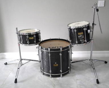
Sold2023Guns N' Roses Matt Sorum "Use Your Illusion Tour" DrumsGuns N' Roses Matt Sorum's "Use Your Illusion Tour" Custom Mapex Orion Drums W/COA - These custom black Mapex Orion drums were used by Matt Sorum during the early 1990s Guns N' Roses Use Your IllusionSee Sold Price
Sold2022GEORGES JOUVE (1910-1964)GEORGES JOUVE (1910-1964) Coupe circulaire creuse en faïence sur talon, décor géométrique abstrait polychrome sur fond blanc, extérieur noir métallisé. Signature incisée « JSee Sold Price
Sold2023British Admiralty Chart #1897 "Victoria Harbour" ex. Coll. Adm. Percy Nelles, 25 1/8".British Admiralty Chart #1897 "Victoria Harbour" ex. Coll. Adm. Percy Nelles, 25 1/8".See Sold Price
Sold2023Late 19thC Bakongo Ancestor Figure Carved Wood African Tribal Statue, DRCCa. late 19thC. Bankongo ancestor figure, Democratic Republic of Congo. Very good with age appropriate wear, including head gear, and glass eyes. Ex-colonial collection Louvain, Leuven Belgium. Ex-TadSee Sold Price
Sold20241719 Map of Colonial era North America, by Sanson - JaillotTitle: 1719 Map of Colonial era North America, by Sanson - Jaillot Date/Period: 1719 Materials: Copperplate engraved Size: 25 1/2 x 18” This map is a rare and valuable map of history, showing NoSee Sold Price
Sold20241889 Ellis & Co. Map of Victoria, BC 24 3/4" x 38 1/2" (acquired Leslie E. Cook Estate 1970).1889 Ellis & Co. Map of Victoria, BC 24 3/4" x 38 1/2" (acquired Leslie E. Cook Estate 1970).See Sold Price
Sold20211889 Guide to West Coast Ports, with 3 mapsHeading: Author: Spreckels, J.D. and Frederick K. Samuels, compilers Title: Ports of San Francisco, San Diego, Puget Sound, Portland and Honolulu. (Cover title) Place Published: San Francisco PublishSee Sold Price
Sold2021Bowles View of Philadelphia, Heap and ScullRare 1778 Engraved map of Colonial Philadelphia after George Heap (1714-1752) and Nicholas Scull (1687-1761), published by Carington Bowles, London, 1778: AN EAST PERSPECTIVE VIEW OF THE CITY OF PHILASee Sold Price
Sold2023Rare 1925 Map of The Town and Harbor of Nantucket by Phillip L. HallRare 1925 Map of The Town and Harbor of Nantucket by Phillip L. Hall, whimsical map showing the town, harbor, ships, aircraft, and prominent landmarks of the island. Overall 23 in. x 15 in.See Sold Price
Sold2022Pauline Simon. Soldier.Pauline Simon. (c. 1894-1976, Poland to America) Soldier. c. 1969. Signed. Oil on canvas. Excellent condition. 24"w x 33"h. Provenance: ex. Sharon and Phillip Linhares, Oakland, CA. Est. $800-1,200. SSee Sold Price
Sold2020Mercator World Map*** START PRICE IS THE RESERVE *** [World] MERCATOR, Rumold (1545-1599). Orbis Terrae Compendiosa Descriptio Quam ex Magna Universali Mercatoris... Engraved Map with original hand color. Geneva, 1587.See Sold Price
Sold2023Pacific Ocean sea chart. Ports lighthouses mail routes dockyards LARGE 1916 mapThe Pacific Ocean' by George Philip & Son Ltd (1916). Antique colour maritime map chart; Scale 1:40,000,000, 49.0 x 69.0cm, 19.25 x 27.25 inches; Please note that this is a folding map. Description: TSee Sold Price
Sold2017De Wit Portolan Sea Chart of EuropeTotius Europae Victoria... Frederic De Wit (1630-1706). Engraved map with original hand color. Amsterdam, 1675. 20 x 35 1/2 inches sheet, 27 1/2 x 43 inches framed. “The most striking and decorativeSee Sold Price
Sold2021West Indies.- Bahamas.- Shattuck (George Burbank) TheNO RESERVE West Indies.- Bahamas.- Shattuck (George Burbank) The Bahama Islands, half-title, plates, folding map (short tear), folding table, cracked hinges, ex-Ministry of Defence library with bookplSee Sold Price
Sold2022(CIVIL WAR.) P.S. Duval & Son. Military Map of the United States & Territories(CIVIL WAR.) P.S. Duval & Son. Military Map of the United States & Territories Showing the Location of the Military Posts, Arsenals, Navy Yards, & Ports of Entry. Hand-colored lithographed pocket mapSee Sold Price
Sold2016LARGE SPANISH COLONIAL SILVER CHOCOLATERAPeru, 1780-1830 sheep’s head spout, articulated handle, 10.5”h; 12”w handle to spout; 61.5 troy oz.; with 15” turned and carved wooden whisk (molinillo) Ex. the collection of a Connecticut genSee Sold Price
Sold2022(COLONIAL NORTH AMERICA.) John Senex, Charles Price, and John Maxwell. North America.(COLONIAL NORTH AMERICA.) John Senex, Charles Price, and John Maxwell. North America. Large engraved map of North America on two sheets of laid paper joined. 39x26¾ inches overall, wide margins;See Sold Price
Sold20181740 Seutter Map of Japan -- Imperium Japonicum perTitle/Content of Map: 1740 Seutter Map of Japan -- Imperium Japonicum per Sexaginta et Sex Regiones Digestum atque ex Ipsorum Japonensium Mappis Descriptum … Date: 1740 c., Augsburg Cartographer: MSee Sold Price
May 16Potter & Potter AuctionsAUDIBERTI, J. Choain. Afrique Equatoriale Francaise. Paris:...$100(1 bid)
May 19Heartland Artifact Auctions Inc2 3/8" Plainview,2x COA- Dickey/Rogers, found in Wilson Co Texas at the Wilson Sand Pit, Ex Bill$10
7 days LeftRail & Road AuctionsMixed Group of Steamship Books, Brochures, Travel Guides, Post Cards, Magazine, Menu, and More$40
May 14Fleischer's Auctions1755 Map Partie de l'Amerique Septentrionale, qui comprend Le Cours de L'Ohio...$200(3 bids)
May 16Potter & Potter AuctionsTUNIS, Edward (1897 – 1973). From Chesapeake Bay / Land of ...$250
5 days LeftJasper52Central America Caribbean Gulf of Mexico chart Ports lighthouses LARGE 1918 map$45
7 days LeftRail & Road AuctionsEleven Port Series Books with Fold Out Maps - No. 9 Through No. 23 - Army Corps of Engineers$20(1 bid)
7 days LeftRail & Road AuctionsEleven Army Corps of Engineers Port Series No. 1 Through No. 8 Books with Fold Out Maps$35(2 bids)
15 hrs LeftTrillium Antique Prints & Rare BooksBesler - Pair of Botanical Engravings: Lily, Iris, Meadow-Rue, Fumitory$200
May 19Heartland Artifact Auctions Inc13 1/4" G10 Mace / Scepter, 2x COA Dickey / Davis, found North of Athens Georgia, EX Richard French$180(8 bids)
2 days LeftTremont Auctions17th century original map 1676 "Virginia and Maryland" by John Speed. 2 sided framing. Overall:$650(3 bids)
2 days LeftTremont AuctionsJohn Speed and Francis Lamb "Map of New England and New York", ca. 1676. Hand colored engraved map$900(3 bids)
May 18Nadeau's Auction Gallery172 Piece Set of Herend "Queen Victoria" Porcelain Dinnerware Set$1,500(1 bid)


![Mercator World Map: *** START PRICE IS THE RESERVE *** [World] MERCATOR, Rumold (1545-1599). Orbis Terrae Compendiosa Descriptio Quam ex Magna Universali Mercatoris... Engraved Map with original hand color. Geneva, 1587.](https://p1.liveauctioneers.com/1968/163248/82424686_1_x.jpg?height=310&quality=70&version=1583340284)


