Sold2018Map of Maine coastlineMap of Maine coastline. 2 part map of Maine coastline. Title: Map of Maine coastline. Unframed. Medium: Paper. Size: 42 X 29See Sold Price
Sold2022Prout's Neck, Maine, Coastline and housesProut's Neck, Maine, Coastline and houses. Detail... houses, flag, sails in distance, dory with sand piper on rail. Title: Prouts Neck, Maine, shoreline. Medium: Oil on Canvas. Signature: Unsigned. FrSee Sold Price
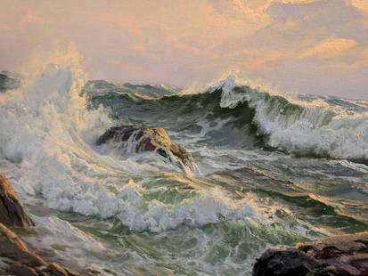
Sold2024Percy Sanborn. Maine. "Matinicus, Maine". Seascape showing waves crashing on a rocky Maine coastlinePercy Sanborn. Maine. "Matinicus, Maine". Seascape showing waves crashing on a rocky Maine coastline with pine trees and seagulls above. Watercolor on paper. Signed lower right. Inscription lower leftSee Sold Price
Sold2021Simon Blaisdell, Maine coastline, double sidedSimon Blaisdell, Maine coastline, double sided. sided Simon A. Blaisdell (1881 - 1965) was active/lived in Maine, New York. Simon Blaisdell is known for Landscape, marine, and portrait painting. MaineSee Sold Price
Sold2019MAPS - Maine. U.S. Gov.Maine. U.S. Gov., [Lot of 2] Map of the Northern Part of the State of Maine and of the Adjacent British Provinces... [and] Extract from a Map of the British and French Dominions in North America, 1838See Sold Price
Sold2021Maine coastline, illegible watercolorMaine coastline, illegible watercolor. Mat edge: 14.50 x 12.50. Title: Maine Coastline. Medium: Watercolor. Size: 4 x 5.50 sight in. Signature: SLR illegible. Artist: Illegible. Unframed.See Sold Price
Sold2021Stephen Kraus, Maine coastlineStephen Kraus, Maine coastline. Frame size: 11 x 9. Title: Maine Coastline. Medium: Watercolor. Size: 3.75 x 4.50 in. Signature: SLL. Artist: Stephen Kraus. Framed.See Sold Price
Sold2022[MANUSCRIPT MAP-MAINE] CHADWICK, JOSEPH. Plan of part of the lands belonging to the Heirs of Brigd.r[MANUSCRIPT MAP-MAINE] CHADWICK, JOSEPH. Plan of part of the lands belonging to the Heirs of Brigd.r Waldo ... measured by Joseph Chadwick Nov.r 1765. [New England]: November, 1765. Manuscript surveySee Sold Price
Sold2017Charles Vickery SUNSET AND SURGING SEA OIL PaintingImpressively sized, signed Charles Vickery, Oil on Canvas . Framed Russel Burton Gallery Chicago .Seascape titled SUNSET AND SURGING SEA of the Maine coastline, that illuminates in regular lighting. NSee Sold Price
Sold2021Mabel May Woodward (American, 1877-1945), MaineMabel May Woodward (American, 1877-1945), Maine Coastlineoil on canvas board, signed at lower right, inscribed on the verso, presented in a later frame with gallery plaque reading "Ogunquit, Maine / MSee Sold Price
Sold2022[MANUSCRIPT MAP-MAINE] After DES BARRES, JOSEPH FREDERICK WALLET. Hand-drawn map of a portion of the[MANUSCRIPT MAP-MAINE] After DES BARRES, JOSEPH FREDERICK WALLET. Hand-drawn map of a portion of the Maine coast off Falmouth, copied from Des Barres. Likely early 19th century. Manuscript map in blacSee Sold Price
Sold2016Ernest Fiene (1894-1965)Rocky Maine Coastline, 1948, Watercolor on paper, 15" x 22", SLR, Framed. Title on verso.See Sold Price
Sold2022John Fulton Folinsbee (1892 - 1972)Charcoal on paper, "study of Maine coastline", unsigned, from the Estate of the artists wife. Coastal landscape. 8.5"h x 11.5"w sight and 14.75"h x 17.75"w framed **Please Note: This item is NOT eligiSee Sold Price
Sold2017Bradford: Antique Map of Maine, 1838Title/Content of Map: Maine by Bradford Date Printed: 1838/1841 Cartographer: Thomas G. Bradford Material/Medium: Paper Size: 13" x 16 1/2" Hand colored. A General Atlas of the World with a Separate MSee Sold Price
Sold2017Mitchell: Antique Map of Maine, 1869Title/Content of Map: Maine by Mitchell Date Printed: 1869 Cartographer: Augustus S. Mitchell Material/Medium: Paper Size: 12" x 15" Hand colored engraved Map. From 'Mitchell's New General Atlas.' PubSee Sold Price
Sold2020Evelyn Maccourt, light house, sailing shipEvelyn Maccourt, light house, sailing ship. Boat and light on Maine's coastline. WWI Female Navy Veteran known for her heavy use of paint in still life paintings. Florida and Ogunquit, Maine painter..See Sold Price
Sold2020Maine 1888Title/Content of Map: Maine 1888 Date Printed: 1888 Material/Medium: paper Size: approx. 11x 14 inches Additional Info: Jonh C. Lonngren & Son Standard Atlas Reserve: $25.00 Shipping: Domestic: Flat-rSee Sold Price
Sold2018Robert Sanstrom.Robert Sanstrom. Abstract signed on Verso Maine Boothbay Area Rocky Shoreline. Title: Maine coastline. Framed. Medium: Oil on Canvas. Size: 20" x 36". Signature: signed on verso. Artist: Robert SanstrSee Sold Price
Sold2020Maine 1896Title/ Content of Map:Maine 1896 Date Printed: 1896 Cartographer: Material/Medium: paper Dimensions: approx. 10.5x 13.5 inches Additional Information: Rand McNally & Co. Universal Atlas of the World RSee Sold Price
Sold2019Maine by JohnsonTitle/Content of Map: Maine by Johnson Date: 1861 Cartographer: Johnson Material/Medium: steel engraved Size: 18x14” Provenance: New York Additional Info: Hand colored Reserve: $20.00 Shipping: DomSee Sold Price
Sold2018Colton: Antique Map of Maine, 1859Title/Content of Map: Maine by Colton Date Printed: 1859 Cartographer: H.J. Colton Material/Medium: Paper Size: 17 1/2" x 15" Hand colored,engraved. Published in New York in 'Colton's General Atlas.'See Sold Price
Sold2017Johnson: Antique Map of Maine, 1868Title/Content of Map: Maine by Johnson Date Printed: 1868 Cartographer: A.J. Johnson Material/Medium: Paper Size: 18" x 24" Hand colored steel engraved Map. From Johnson's New Illustrated Family AtlasSee Sold Price
Sold2023THREE MAPS OF MAINE 19th CenturyTHREE MAPS OF MAINE19th Century1) J.J. Stoner map of Thomaston. Framed 20.25” x 28”.2) E.M. Woodford 1855 rolled map of Thomaston Village. Approx. 47” x 39”.3) Lee & Marsh 1857See Sold Price
Sold2021Ethel B Fowler 1931 Boothbay Harbor Maine MapEthel B Fowler; The Bridge House Studio, 1931 Vintage "Boothbay Harbor and Vicinity" Maine Historical map, mixed media print or Poster, signed and dated in the art and framed. Height of art 24 1/2 incSee Sold Price
May 05Kellie's Estate SalesAcadia National Park Framed Map 1966 Sunrise over Acadia map by August D. Phillips of Northeast$5
589 Lots AwaySMG MarketingEdward Willis Redfield- 5.75 x 3.25 Signed Vintage Notecard (Impressionist Painter)$150
23 hrs LeftSMG MarketingEdward Willis Redfield- 5.75 x 3.25 Signed Vintage Notecard (Impressionist Painter)$150
2 days LeftSMG MarketingEdward Willis Redfield- 5.75 x 3.25 Signed Vintage Notecard (Impressionist Painter)$150
May 10Rail & Road AuctionsEleven Army Corps of Engineers Port Series No. 1 Through No. 8 Books with Fold Out Maps$35(2 bids)
May 09Rail & Road AuctionsSix Southeastern Railroad Annual Passes - 1876 Pioneer Steamboat Line, 1892 Atlantic Coast Line, and$50
May 14Fleischer's Auctions1755 Map Partie de l'Amerique Septentrionale, qui comprend Le Cours de L'Ohio...$200(3 bids)
7 days LeftConestoga Auction Company Division of Hess Auction GroupH.G. Eastman Sailboats and Coastline Painting.$80(3 bids)


![MAPS - Maine. U.S. Gov.: Maine. U.S. Gov., [Lot of 2] Map of the Northern Part of the State of Maine and of the Adjacent British Provinces... [and] Extract from a Map of the British and French Dominions in North America, 1838](https://p1.liveauctioneers.com/6576/142214/71976779_1_x.jpg?height=310&quality=70&version=1557929467)


![[MANUSCRIPT MAP-MAINE] CHADWICK, JOSEPH. Plan of part of the lands belonging to the Heirs of Brigd.r: [MANUSCRIPT MAP-MAINE] CHADWICK, JOSEPH. Plan of part of the lands belonging to the Heirs of Brigd.r Waldo ... measured by Joseph Chadwick Nov.r 1765. [New England]: November, 1765. Manuscript survey](https://p1.liveauctioneers.com/292/250642/130213647_1_x.jpg?height=310&quality=70&version=1654271664)

![[MANUSCRIPT MAP-MAINE] After DES BARRES, JOSEPH FREDERICK WALLET. Hand-drawn map of a portion of the: [MANUSCRIPT MAP-MAINE] After DES BARRES, JOSEPH FREDERICK WALLET. Hand-drawn map of a portion of the Maine coast off Falmouth, copied from Des Barres. Likely early 19th century. Manuscript map in blac](https://p1.liveauctioneers.com/292/250642/130213649_1_x.jpg?height=310&quality=70&version=1654271664)


