Sold2018Map Prison Philadelphia Pennsylvania 1841 DemetzPRISON DE COMTE A PHILADELPHIA. PENNSYLVANIA. PAR THOMAS WALTER ARCH. Beautiful collection of four prints taken from the scarce work of 1841 about american prisons Rapports a M. Le Comte de MontalivetSee Sold Price
Sold2023Folk Art Carved Fish PlaqueFolk art carved fish plaque. Carved wood with original paint. Wethersfield, Connecticut. 1905. The back includes a note from the board of directors of the Connecticut state prison. Plaque created by aSee Sold Price
Sold2023MAP, Connecticut, ReidConnecticut. John Reid, Connecticut from the Best Authorities, from Winterbotham's History of America, 1796 (circa). Black & White. This early and uncommon map of Connecticut was engraved by BenjaminSee Sold Price
Sold2022MARGUERITE ZORACH View of Wethersfield Cove, Connecticut.MARGUERITE ZORACH View of Wethersfield Cove, Connecticut. Lithograph with hand coloring in watercolor, 1929. 292x440 mm; 11½x17½ inches, full margins. Edition of 30. Signed, dated and numberSee Sold Price
Sold2021Dec 1841 Connecticut Dem. Party State Voting PlanPolitical December 30, 1841-Dated Confidential Letter Detailing Connecticut Democratic Party Efforts to Defeat Whigs, etc. December 30, 1841-Dated, Confidential Political Letter detailing the ConnectiSee Sold Price
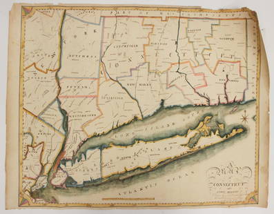
Sold2023EARLY CONNECTICUT MAPHand drawn and colored; "Connecticut and Parts Adjacent", "drawn by Miss. Elizabeth L. Tredwell" "Christ Church Academy 1820", several edge tears; 23" x 30", F-GSee Sold Price
Sold20221796 Reid Map of Connecticut -- Connecticut from the Best AuthoritiesTitle: 1796 Reid Map of Connecticut -- Connecticut from the Best Authorities Cartographer: J Reid Year/Place: 1796 Dimensions: 13.9 X 17.1 in. Description: This is an excellent, early and uncommon mapSee Sold Price
Sold2023Five Antique American MapsFive Antique American Maps, incl. "Map of Oregon and Upper California..." 1848, Charles Preuss; "map of Connecticut Showing the System of Trunk Line Highways...", 1932; "Map of the Valley of Mexico",See Sold Price
Sold2017Bradford: Antique Map of Texas, 1841Item: Map of Texas Maker: Thomas J. Bradford Date: 1841 Matted Size: With matte measures 18 1/2" x 15 3/4" Please note that this lot has a confidential reserve. When you leave a bid in advance of theSee Sold Price
Sold20181859 Clark & Tackabury Antique Connecticut Wall MapTitle/Content of Map: 1859 Clark & Tackabury Connecticut Wall Map -- Clark & Tackabury's New Topographical Map of the State of Connecticut Date Printed: 1859 Philadelphia Cartographer: Clark and TackaSee Sold Price
Sold20231841 Wilkes Map of the Pacific Northwest -- Map of the Oregon Territory by the U.S. Ex. Ex.Title: 1841 Wilkes Map of the Pacific Northwest -- Map of the Oregon Territory by the U.S. Ex. Ex. Cartographer: C Wilkes Year / Place: 1841 Map Dimension (in.): 22.8 X 33.8 in. This is a superb, impoSee Sold Price
Sold2022English issue of Wilkes map of Oregon TerritoryMap of the Oregon Territory by the U.S. Ex. Ex. Charles Wilkes, Esqr. Commander 1841, engraved map, sectioned for folding, 58.5x89 cm. (23x35 inches), folding English version of the map originally appSee Sold Price
Sold2023Collection of MapsCollection of maps including; 1.) Travel Map of Massachusetts, Connecticut and Rhode Island published by B. Brown & Parsons, Hartford, Connecticut, 1838. Map measures 14.5" x 20". Map exhibits some spSee Sold Price
Sold2021Connecticut44. Connecticut.Clark & Tackabury's New Topographical Map of the State of Connecticut. Fine hand-colored map in 24 sections. 56-1/2 x 72 inches, linen-backed, gilt-lettered cloth portfolio with stringSee Sold Price
Sold2022Map of the Town of Cornwall, Connecticut, Circa 1854Map of the Town of Cornwall, Connecticutcirca 1854marked "Map of the Town of Cornwall, Litchfield County, Connecticut, Surveyed & Drawn by L. Fagan, Published by Richard Clark, 42, Moyamensing RoSee Sold Price
Sold2017RENOIR, Pierre-Auguste. Etching "Le Chapeau?pingl?". With stamped signature lower right. Pierre-Auguste Renoir (French, 1841-1919). From a Fairfield, Connecticut home. - Dimensions: Plate - 5.125" high x 3.75" wide.See Sold Price
Sold2019CATLIN, George (1796-1872). Letters and Notes on theCATLIN, George (1796-1872). Letters and Notes on the Manners, Customs, and Condition of the North American Indians. London: Published by the Author, 1841. 2 volumes, 8vo. 3 maps (one folding) and 176See Sold Price
Sold2022Connecticut Queen Anne Carved Cherry Dressing Tableprobably Wethersfield area, circa 1740-1760, with molded top over four dovetailed drawers, central drawer with deep fan carving, scalloped skirts, cabriole legs with pad feet, white pine secondary, 33See Sold Price
Sold2023Connecticut Queen Anne Shell Carved Cherry High Chest of Drawersprobably Wethersfield area, mid 18th century, upper case with deeply carved shell drawer flanked by two small drawers over four graduated long drawers, conforming lower case with shell carved drawer,See Sold Price
Sold2022Evans, Lewis A General Map of the Middle British Colonies in AmericaEvans, Lewis A General Map of the Middle British Colonies in America viz. Virginia, Maryland, Delaware, Pensilvania, New-Jersey, New York, Connecticut and Rhode Island: of Aquanishuonigy the Country oSee Sold Price
Sold2022Crevecoeur French Edition of Evans Map of Middle ColoniesCREVECOEUR, Michel Guillaume De (1735-1813). Carte Generale des Etats de Virginie, Maryland, Delaware, Pensilvanie, Nouveau-Jersey, New-York, Connecticut et Isle de Rhodes Ainsi que des Lacs Erie, OntSee Sold Price
Sold20211870 LARGE FRENCH ANTIQUE MAP OF PARIS Logerot editeurhis large French map of Paris circa 1870 was edited by “Auguste Logerot ( 1841-1879) . Logerot made use of the works of the well known cartographers Fremin, Dufour, Dyonnet, and Vuillemin. He publisSee Sold Price
Sold2016Nashville Battlefields and TN MapTwo Tennessee related maps. 1st item: A NEW MAP OF TENNESSEE WITH ITS ROADS AND DISTANCES FROM PLACE TO PLACE ALONG THE STAGE AND STEAM BOAT ROUTES by H.P. Tanner, dated 1841, showing counties, canalsSee Sold Price
Sold2020Two Small Framed Early Mapsincluding Connecticut and Virginia. Not examined out of frames. Largest frame size: 11 1/3" high, 13 3/4" wide. Stains, toning, creases. Provenance: Property of a Madison, CT Collector. VirSee Sold Price
6 days LeftWorthington Galleries4 Antique Civil War Engraving Plates Regarding the Elmira Prison Camp$100
May 15Fleischer's Auctions[CIVIL WAR]. Soldier's Letter w/ Revealing Racist Remarks, POW Chancellorsville, DOD Annapolis$100
6 days LeftTrillium Antique Prints & Rare BooksWilkes - 3 Maps of Australian, Samoan or Navigator Islands, & Island of Tahiti$100
6 days LeftTrillium Antique Prints & Rare BooksWilkes - Pair of Maps of California and the Pacific Ocean$100
4 days LeftHunt and Peck Estate Services, Inc.1862 Henry Mayhew and John Binny 1st Edition "The Criminal Prisons of London and Scenes of Prison$200
6 days LeftTrillium Antique Prints & Rare BooksWilkes - Corrobory (Corroboree) Dance (Australian Aboriginal Custom)$100
3 days LeftJasper52VANITY FAIR SPY CARTOON Paul de Granier de Cassagnac 'a French duellist'. T 1879$20


![[CIVIL WAR]. Soldier's Letter w/ Revealing Racist Remarks, POW Chancellorsville, DOD Annapolis (1 of 2)](https://p1.liveauctioneers.com/7226/325455/175169055_1_x.jpg?height=282&quality=70&version=1712370394)
![[Libby Prison] USN Button w/ Incredible Story (1 of 4)](https://p1.liveauctioneers.com/7226/325455/175169135_1_x.jpg?height=282&quality=70&version=1712370394)


