Sold2021Blaeu 1635 Map of Tartaria (Northern Asia)Finely engraved map by cartographer Blaeu depicting Tartaria, a term used for Central and Northern Asia. This map includes knowledge of English and Dutch explorers through Greek classics, such as mythSee Sold Price
Sold2021Blaeu 1635 Map of Tartaria (Northern Asia)Finely engraved map by cartographer Blaeu depicting Tartaria, a term used for Central and Northern Asia. This map includes knowledge of English and Dutch explorers through Greek classics, such as mythSee Sold Price
Sold2016Blaeu, W.: Walachia, Servia, Bulgaria, Romania Map 1635Map: Walachia, Servia, Bulgaria, Romania Publishing: Blaeu, W.: Amsterdam Date: 1635 Size: 15 x 20 inches Early edition of a very attractive map of the Balkans, shown during the occupation by the OttoSee Sold Price
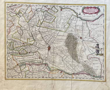
Sold2023The Netherlands Map. The region Around the city of Utrecht. 1660?s by W. BlaeuTitle: The Netherlands Map. The region Around the city of Utrecht. 1660?s by W. Blaeu Date/Period: 1660?s Materials: Hand colored copper plate engraved Size: 22 x 19 1/2'' Netherlands regional map cenSee Sold Price
Sold2019Two Maps by Willem Janszoon Blaeu (1571-1638),Two Maps by Willem Janszoon Blaeu (1571-1638), "Virginiae partis australis et Florida partis orientalis," 1640, hand colored, H. - 15 in., W. - 20 in.; together with India Quae Orientalis Diktur et InSee Sold Price
Sold2019Two Maps by Willem Janszoon Blaeu (1571-1638,Two Maps by Willem Janszoon Blaeu (1571-1638, Amsterdam), "Noramndia Ducatus (with History on reverse)," 1640; together with "Languedoc," 1640, hand colored, Languedoc- H. - 19 in., W. 24 in., DucatusSee Sold Price
Sold2019Two Maps by Willem Janszoon Blaeu (1571-1638,Two Maps by Willem Janszoon Blaeu (1571-1638, Amsterdam), "Burgundia Ducatus," 1640; together with "Champagne Latine Campania Comitatus," 1640, hand colored, Champagne- H. - 16 in., W. - 23 in., BurguSee Sold Price
Sold2018Blaeu Map of Europe -- Europa Recens DescriptaTitle/Content of Map: Blaeu Map of Europe -- Europa Recens Descripta Date: 1635, Amsterdam Cartographer: W Blaeau Size: 16.1 X 21.9 in. This is a grand, large, classic map of Europe, produced at the gSee Sold Price
Sold2019Unknown, "Asia from the Best Authorities," togetherUnknown, "Asia from the Best Authorities," together with two leaflets, "Neue Zeitungen von Gelehrten Sachen," 1733 and "The World" by Adam Fitz-Adam, 1754, Map- H.- 8 1/2 in., W.- 10 in. (3 Pcs.)See Sold Price
Sold2019Two Maps from the Hydrographic Office U. S. Navy, theTwo Maps from the Hydrographic Office U. S. Navy, the first "Asia, Korea, Southeast Coast, Fusan Ko," 1945, H. - 42 in., W. - 30 in.; together with "England- East Coast, North Foreland to Orfordness,See Sold Price
Sold2018Finck/Merian: Antique View of Salvador, Brazil, 1635Map: S. Salvador Cartographer: Finck/Merian Place & Date: Frankfurt / 1635 Size: 14 1/4" x 7 1/2" Condition: b&w; overall age toning A dramatic view of the Brazilian city of Salvador with a naval battSee Sold Price
Sold2024Blaeu, pub. 1635 - Map of Romania: TransylvaniaThis remarkable, map with original hand-coloring is is Jan Blaeu's Le Theatre du Monde ou Nouvel Atlas Contenant, Les Chartes et Descriptions de tous les Pais de la Terre Mis en lumiere. This is fromSee Sold Price
2023Blaeu, pub. 1635 - Map of Scandinavia (Norway, Finland, Sweden)This remarkable, map with original hand-coloring is is Jan Blaeu's Le Theatre du Monde ou Nouvel Atlas Contenant, Les Chartes et Descriptions de tous les Pais de la Terre Mis en lumiere. This is fromSee Sold Price
Sold2021WILLIAMS W. Map of Asia Showing the Gt. PoliticalWILLIAMS W. Map of Asia Showing the Gt. Political Divisions and also Showing the Various Routes of Travel between London & India, China, Japan. Philadelphia: N.d. Plate 115. 20 1/4 x 23 1/4 in. MattedSee Sold Price
Sold2018(1635) Blaeu Map: Mappa Aestivarvm Insularum,...Historic Maps Hand-Colored "Mappa Aestivarvm Insularum, alias Barmvdas dictarum..." by Willem J. Blaeu, Amsterdam (1635) Hand-Colored Historic Dutch Map titled: "Mappa Aestivarvm Insularum, alias BarmSee Sold Price
Sold2023TRAVEL 1926 SOUTHEAST ASIA w MAP, MALAYSIA & INDOCHINA by THOS. COOK & SONTRAVEL 1926 SOUTHEAST ASIA w MAP, MALAYSIA & INDOCHINA by THOS. COOK & SON TRAVEL 1926 SOUTHEAST ASIA w MAP, MALAYSIA & INDOCHINA by THOS. COOK & SON Description Old antique book titled; "MALAYSIA ANDSee Sold Price
Sold2022Spanish Leather Domed Trunk w Map of Central AsiaSpanish Tooled Leather Domed Trunk with World Map & Nailhead Trim. Velvet lined interior/ Measures 19 inches x 35.5 inches x 18.5 inches.See Sold Price
Sold2019Natolia quae olim Asia Minor Old MapBlaeu's decorative map of Asia Minor, showing Turkey, Cyprus and the Islands in the Aegean. This attractive map shows all of Turkey, Cyprus and the Aegean Islands to a relatively high degree of accuraSee Sold Price
Sold20241852 Mitchell Map of Asia -- No. 26 Map of AsiaTitle: 1852 Mitchell Map of Asia -- No. 26 Map of Asia Cartographer: S Mitchell Year / Place: 1852, Philadelphia Map Dimension (in.): 8 x 10.5 in. This is an excellent map of Asia. Key cities, topograSee Sold Price
Sold2018Siku, StadtplanSiku, City Map, W.-Germany, out of paper, severe traces of usageSee Sold Price
Sold20211635 Blaeu Engraved Map of LutzenburgAn engraved map of Lutzenberg attributed to Willem Blaeu circa 1635. Fine condition, measures 5.25 x 5". Reserve: $40.00 Shipping: Domestic: Flat-rate of $8.00 to anywhere within the contiguous U.S. ISee Sold Price
Sold20211729 HISTORY of JEWS w/ MAPS of GREECE PALESTINE ASIAPRIDEAUX, H. Het oude & niewe verbond aen een geschakelt in de geschiedenissen der Joden en der aengrenzende volkeren, sedert het verval der koningryken van Israel en Juda tot de komst van Jezus KristSee Sold Price
Sold2017Johnson's United States, 1870A.J. Johnson, Johnson, A.J., 1870, Double Folio – 16.00 H x 22.00 W Inches, Map detailing towns, cities, townships, forts, topography and railroads in the continental U.S. Dakota not separated. ShowSee Sold Price
Sold2021US Occupation Zone Cigarette Case-1947US Occupation Zone Metal Cigarette Case. 1947. German Map w/ German City Name Engraved. Open/Close Button is in Working Condition. Enameled. USAAF Winged Propeller Logo. Plated Brass with some Wear. PSee Sold Price
Featured2 days LeftJasper52Mitchell’s Map of Asia showing travel routes London, India, China & Japan, 1860$45
2 days LeftJasper521894 Johnston Map of Oceania [verso] Island in the Indian Ocean and Near Africa -- Oceania [verso]$40
Jun 07Freeman's | Hindman[MAP]. TODESCHI, Pietro. [Nova et Acurata Totius Americae Tabula auct. G.I. Blaeu] America quarta$5,000


![1894 Johnston Map of Oceania [verso] Island in the Indian Ocean and Near Africa -- Oceania [verso] (1 of 2)](https://p1.liveauctioneers.com/5584/328338/176911535_1_x.jpg?height=282&quality=70&version=1715113718)


![[MAP]. TODESCHI, Pietro. [Nova et Acurata Totius Americae Tabula auct. G.I. Blaeu] America quarta (1 of 1)](https://p1.liveauctioneers.com/197/329395/177650542_1_x.jpg?height=282&quality=70&version=1715364962)


