Sold2017Rand McNally Map of Minnesota, 1882Map: Rand McNally Map of Minnesota - Rand McNally & Company's Indexed Atlas of the World (Minnesota) Cartographer: Rand McNally Date: 1882 Origin: Chicago Size: 13.3 x 19.4 inches A nice county map ofSee Sold Price
Sold2021Antique Indexed Map of BostonAntique Indexed Map of Boston, hallmark to center right reads ‘ Published by WALKER LITH. & PUB CO. 400 Newbury St, Boston’, verso reads ‘A.I. FRIEDMAN’, subject a map of the city of BSee Sold Price
Sold20221930's Road Maps Minnesota, Oregon & Ontariorated 7 to 8, 9"x4", light wear.See Sold Price
Sold2019Minnesota, Dakota’sTitle/Content of Map: Minnesota, Dakota’s Date: 1863 Cartographer: By Johnson & Ward. From, Johnson’s New Illustrated Family Atlas Size: 18x14” Provenance: New York Additional Info: Hand coloredSee Sold Price
Sold2018Colton: Antique Map of Minnesota & Dakota, 1859Title/Content of Map: Minnesota & Dakota by Colton Date Printed: 1859 Cartographer: H.J. Colton Material/Medium: Paper Size: 17 1/4" X 15" Hand colored,engraved. Published in New York in 'Colton's GenSee Sold Price
Sold2021Group of 4 1933 Century of Progress Worlds FairIncludes a bag from the Hungarian Pavilion, a promotional Guide and map, a book on The Chinese Lama Temple, and an indexed map.See Sold Price
Sold2019Portland OregonTitle: Portland Oregon Publication Date: 1938 Cartographer: Publisher: Byington Printing Co. Size: 20.5 X 23 Nonpareil Indexed Map of Portland Oregon. Authorized Guide to New Street Transportation SysSee Sold Price
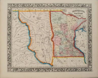
Sold2017Colton: Antique Map of Minnesota, 1871Title/Content of Map: Minnesota by Colton Date Printed: 1871 Cartographer: G. W. Colton Material/Medium: Paper Size: 15" x 17" Hand colored lithograph. From 'Colton's American Atlas.' Published in NewSee Sold Price
Sold2017Mitchell: Antique Map of Minnesota, 1869Title/Content of Map: Minnesota by Mitchell Date Printed: 1869 Cartographer: Augustus S. Mitchell Material/Medium: Paper Size: 12" x 15" Hand colored engraved Map. From 'Mitchell's New General Atlas.'See Sold Price
Sold2019Maps of the Oil Fields of California, 1910Heading: (California - Oil) Author: Title: California Oil Fields: Up to date indexed maps Place Published: Bakersfield, CA Publisher:Barlow & Hill Date Published: 1910 Description:See Sold Price
Sold2017Maps of Kern County Oil Fields 1901Heading: (California - Kern County) Author: Title: Up-to-Date Accurate Indexed Maps. Kern Co. Oil Fields, California. Place Published: Bakersfield, CA Publisher:Hall, Barlow & Austin Date PublisSee Sold Price
Sold2023Map of Minnesota Territory by J.H. Young, 1854Map of Minnesota Territory by J.H. Young, Published by Cowperthwait, Desilver & Butler, Philadelphia, 1854. Scale 1:2,400,000 Image measures 15 1/2" x 12 1/2". Frame measures 22&quSee Sold Price
Sold2016MAP OF MINNESOTA TERRITORY BY J.H. YOUNG 1854Hand tinted lithograph map by J.H. Young, Cowperthwait, Desilver & Butler, 1854. Measures 14 x 17.2 inches overall. Depicts the Minnesota territory, lakes, rivers, forts, and native American tribal reSee Sold Price
Sold2018Early pocket map of MinnesotaHeading: Author: Colton, J.H. Title: Minnesota Place Published: New York Publisher:J.H. Colton & Co Date Published: 1855 Description: Folding color map, 12 x 15 inches. FolSee Sold Price
Sold2017Young: Map of Minnesota Territory, 1850Map: Map of Minnesota Territory Maker: J. H. Young Publisher: Cowperthwait, DeSilver & Butler Publishing Date: 1850 (1854) "Important early map of Minnesota Territory, including all of Dakota, from thSee Sold Price
Sold20201855 Colton Map of Minnesota and the Dakotas --Title: 1855 Colton Map of Minnesota and the Dakotas -- Minnesota Cartographer: J Colton Year/Place: 1855, New York Size: 11.8 X 15.7 in. Description: This is an excellent map of Minnesota and the emerSee Sold Price
Sold20191855 Colton Map of Minnesota and the Dakotas --Reserve Reduced! Title/Content of Map: 1855 Colton Map of Minnesota and the Dakotas -- Minnesota Date: 1855, New York Cartographer: J Colton Size: 11.8 X 15.7 in. This is an excellent map of MinnesotaSee Sold Price
Sold20201858 Map of Minnesota and DakotaAuthor: Johnson Title: 1858 Map of Minnesota and Dakota Medium: Ink on Paper Dimensions: 18"X14.5" Map of Minnesota and Dakota dated 1858. Engraved by A.J. Johnson. Published by Johnson and Ward in NeSee Sold Price
Sold20211867 Colton Map of Minnesota -- MinnesotaTitle: 1867 Colton Map of Minnesota -- Minnesota Cartographer: G & C Colton Year / Place: 1867, New York Map Dimension (in.): 23.3 X 16.8 in. This is an excellent doubble page map of Minnesota. The noSee Sold Price
Sold20201860 Mitchell Map of Minnesota and the DakotasTitle/Content of Map: 1860 Mitchell Map of Minnesota and the Dakotas --Minnesota and Dacotah Date: 1860, Philadelphia Cartographer: S Mitchell Size: 10.6 X 13.3 in. This is a rather nice map of MinnesSee Sold Price
Sold2022County Map of Minnesota from S. A. Mitchell, Jr. (1874)Fully hand colored map of Minnesota divided into counties. Towns, capitols, roads, rivers, lakes, railroads, and proposed railroads are labeled. A wagon road from Fort Ridgely westward toward the MissSee Sold Price
Sold20191938 R Taylor White Pictorial Map of Minnesota --Title: 1938 R Taylor White Pictorial Map of Minnesota -- Minnesota Date: 1938, Boston Cartographer: Ruth Taylor White Size: 11.6 x 8.5 in. Additional Information: This is Ruth Taylor White's charmingSee Sold Price
Sold2017Colton: Antique Map of Minnesota, 1867Huge 1867 Minnesota map by Colton. Very fine example of this early large format map. Finely engraved map of the state with inset of the north-eastern portion at upper right. Highly detailed with identSee Sold Price
May 14Fleischer's Auctions1755 Map Partie de l'Amerique Septentrionale, qui comprend Le Cours de L'Ohio...$200(3 bids)
May 05Tremont AuctionsJohn Speed and Francis Lamb "Map of New England and New York", ca. 1676. Hand colored engraved map$900(3 bids)
May 05Tremont Auctions17th century original map 1676 "Virginia and Maryland" by John Speed. 2 sided framing. Overall:$325(2 bids)
22 hrs LeftRenew GalleryCirca 1815 Engraved Map A Plan of the Grand of the New Townships on the Grand or Ottawa River$100
19 hrs LeftTrillium Antique Prints & Rare BooksPtolemy & Magini, pub. 1620 - Map of the World with Six Windheads$130(4 bids)
May 05Tremont Auctions18th century map of New Jersey. "A New and Accurate Map of New Jersey". W. Long, London. Map size 13$100
18 hrs LeftNadeau's Auction GalleryMap of the Northwest Port of Canada, Indian Territories Hudson's Bay$150
May 12Schilb Antiquarian Rare Books1977 JRR Tolkien 1st ed 1st Printing Silmarillion Lord of the Rings + MAP + DJ$200(5 bids)
19 hrs LeftTrillium Antique Prints & Rare BooksPtolemy & Magini, pub. 1620 - Double Hemisphere Map of the World$400(5 bids)
6 days LeftDixon's Crumpton AuctionPre-Central Park Map of New York City, David H. Burr / Simeon DeWitt 1829$100(3 bids)


![[Maps] American Atlas, Folio (1 of 14)](https://p1.liveauctioneers.com/3532/326332/175680379_1_x.jpg?height=282&quality=70&version=1713151485)


