Sold202118th C. French Map "Le Noveau Mexique …"Ribobert Bonne (French, 1727-1794). "Le Nouveau Mexique, Avec La Partie Septentrionale De L'Ancien, ou De La Nouvelle Espagne" Published in Paris, 1780. Among the most collected late 18th century mapsSee Sold Price
Sold2021Pair 18th C French Maps after the AntiqueTo include "A View of the Town-House or Guild Hall of Paris" and "Vue de Chateau Royal D'amboise" : mid 20th century prints after the antique, housed in concave giltwood frames. Copperplate engravingsSee Sold Price
Sold20181791 French Revolutions de Paris Prudhomme MAPS Illustr1791 French Revolutions de Paris Prudhomme MAPS Illustrated LaFayette France Louis Marie Prudhomme was an 18th-century French historian who is known for his satirical and sarcastic articles on the FreSee Sold Price
Sold20191791 1ed French Revolutions de Paris Prudhomme MAPS1791 1ed French Revolutions de Paris Prudhomme MAPS Illustrated LaFayette France Louis Marie Prudhomme was an 18th-century French historian who is known for his satirical and sarcastic articles on theSee Sold Price
Sold20181790 French Revolutions de Paris Prudhomme Rhine MAP1790 French Revolutions de Paris Prudhomme Rhine MAP Illustrated LaFayette France Louis Marie Prudhomme was an 18th-century French historian who is known for his satirical and sarcastic articles on thSee Sold Price
Sold20201790 French Revolutions de Paris Departments France1790 French Revolutions de Paris Departments France MAPS Pas de Calais Louis Marie Prudhomme was an 18th-century French historian who is known for his satirical and sarcastic articles on the French ReSee Sold Price
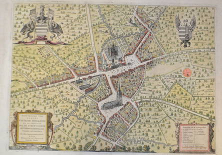
Sold20201765 Paris FRANCE City View Maps Architecture Art1765 Paris FRANCE City View Maps Architecture Art Piganiol ILLUSTRATED A rare geographical study of France by Piganiol! Piganiol de la Force was an 18th-century French author known almost exclusivelySee Sold Price
Sold20201765 Paris FRANCE City View Maps Architecture Art1765 Paris FRANCE City View Maps Architecture Art Piganiol ILLUSTRATED A rare geographical study of France by Piganiol! Piganiol de la Force was an 18th-century French author known almost exclusivelySee Sold Price
Sold2017GEORGE-LOUIS LE ROUGE (FRENCH, 18TH CENTURY)GEORGE-LOUIS LE ROUGE (FRENCH, 18TH CENTURY) REVOLUTIONARY WAR MAP hand-colored engraving on laid paper, "Theatre du Guerre en Amerique", published in Paris 1777, includes a small vignette of NiagaraSee Sold Price
Sold20221722 Paris FRANCE Architecture Illustrated Notre Dame1722 Paris FRANCE Architecture Illustrated Notre Dame MAPS City Plans Force 2v A rare geographical study of France by Piganiol! Piganiol de la Force was an 18th-century French author known almost exclSee Sold Price
Sold20201790 French Revolutions de Paris Prudhomme Illustrated1790 French Revolutions de Paris Prudhomme Illustrated Haute Saone Bas Rhin MAP Louis Marie Prudhomme was an 18th-century French historian who is known for his satirical and sarcastic articles on theSee Sold Price
Sold2021A GROUP OF TWO 18TH CENTURY MAPS OF THE AMERICAS,A GROUP OF TWO 18TH CENTURY MAPS OF THE AMERICAS, LONDON AND PARIS, 1736-1780, two hand-colored engravings on paper, comprising, "FLORIDA Called by ye French LOUISIANA," after works by Herman Moll (16See Sold Price
Sold202118TH C. MAP OF THE PERSIAN COAST, FRAMED"A Chart of the Coast of Persia, Guzarat & Malabar, drawn from the French Chart of ye Eastern Ocean, Publish'd in 1740, by Order of the Count de Maurepas, improved from particular Surveys and regulateSee Sold Price
Sold201718th C. French Map w/ Oiled Paper, ex-Sotheby'sEurope, France, map from 1709 CE, oiled paper overlays from 1756 to 1763 CE, owned by Louis-Alexandre Berthier (1753 to 1815 CE), Marshal, Vice-Constable of France, and Chief of Staff (Major general)See Sold Price
Sold2018Framed 18th C. French Map of Ancient Rome**First Time At Auction** Louis Brion de la Tour (French, 1743-1810) & Louis Charles Desnos (French, 1725-1805), "Suite De L'Histoire De Rome", ca. 1760 to 1770. Copperplate engraved with original hanSee Sold Price
Sold201518th C French Map Of SteenvoordePLOUICH, Vedastus du -" Illvstrissimo viro domino" .The city of Steenvoorde is a small town located north of France. The city of Steenvoorde is located in the department of Nord of the french region.See Sold Price
Sold201718th Century French Map of North AmericaL’Amerique Septentrionale. Daniel de la Feuille (1640-1709). Engraved map with hand color in full. Amsterdam, 1702 or 1706. 6 x 8 inches visible, 13 x 14 1/2 inches framed. Nicely colored early 18thSee Sold Price
Sold202118TH CENTURY FRENCH MAP OF SOUTHEASTERN USRigobert Bonne (French, 1727-1794). "Carte De la Partie Sud Des Etats Unis De L'Amerique Septentrionale" -circa 1780, engraving. Provenance: From the Lifetime Collection of Billy S. Arant, Jr., ChattaSee Sold Price
Sold2019.18th Century French Map of Cuba, Florida and Louisiana21 1/4 x 16 3/4 in. (framed).18th Century French Map of Cuba, Florida and LouisianaGulf of Mexico antique map Golfe du Mexique Zannoni 1762Title: Carte Geo-Hydrographique du Golfe du Mexique et de sesSee Sold Price
Sold202118TH CENTURY FRENCH MAP OF THE WORLDDimensions: Frame: H 14.5" x W 19.35" Sight: H 9.25" x W 13.75" Condition: Discolored old watercolor, some toning to mat.See Sold Price
Sold2020Group of French Maps Guillaume de l'Isle SansonGroup of four 17th and 18th century French maps. Guillaume Delisle (1675-1726) hand colored engraved map of Picardie, 1748. Two maps by Nicolas Sanson (1600-1677), "Le Roayaume de France" and "GouvernSee Sold Price
Sold2018VINTAGE REPRODUCTION 18TH C. MAP OF PARISDimensions: (Frame) H 33" x W 44.75", (Sight) H 29" x W 40.5" Condition: Slight discoloration and buckling to paper. Some light wear to frame.See Sold Price
Sold2022GUILLAUME DE LISLE (1675-1726), AN 18TH CENTURY FRENCHGUILLAUME DE LISLE (1675-1726), AN 18TH CENTURY FRENCH COLONIAL MAP, "Carte de la Louisiane et de Cours du Mississipi," AMSTERDAM, CIRCA 1727, engraving on paper with ink inscriptions, after GuillaumeSee Sold Price
1 day LeftA.H. Wilkens Auctions & AppraisalsPAIR OF 18th C PERSIAN SILVER TORAH FINIALSCA$125(2 bids)
2 days LeftPrime Auction Gallery, Inc.Late 18th C. French Louis Style XV Marquetry Bronze Mounted Commode$1,700
Jun 09Worthington Galleries18th c. Map OBSERVATIONS SUR LES POINTS CARDINAUX. LIGNES, ET CIRCLES DE LA SPHÈ$10
3 days LeftAuction Plus, Inc.Set Of Four Late 18th C. French Hand Painted Jeweled & Enamel Sevres Plates$4,000
Jun 13DuMouchellesLuigi Fabris (Italian, 1883-1962) Capodimonte Porcelain Plateau Group 1920-1930, "Bascule", H 9" W$250(3 bids)