Sold2022Mission & Noe Valley subdivision, 1854Heading: -1854 Author: Gardiner, James J. Title: Map of Horner's Addition City of San Francisco Surveyed for John M. Horner by J.J. Gardiner City & County Surveyor, San Francisco June 1st 1854 Place PSee Sold Price
Sold2021Explorations and Surveys. War Department. Map No. 1 RioTitle: Explorations and Surveys. War Department. Map No. 1 Rio Colorado of the West, - Map No.2. Rio Colorado of the West, Publication Date:1858 Cartographer: EGLOFFSTEIN, FRIEDRICH WILHELM, freiherrSee Sold Price
Sold2020Subdividing the Seale Tract in Old Palo Alto, 1936Heading: (California - Palo Alto) Author: Perrott, Thelo A. Title: Tract No. 44 - Emery Subdivision, Map No. 2. Subdivision of Blocks 85 and 96 Seale Tract, Palo Alto, California. Surveyed September 1See Sold Price
Sold2022Subdividing Orange County fruit ranch 1894Heading: (California - Anapauma) Author: Finley, S. H., surveyor Title: Subdivision map of Anapauma showing the fruit lands of David Hewes located in Orange County, California, containing 820 acres PlSee Sold Price
Sold2022Original Map of Daly Addition Annex, Butte [151280]Original map of Daly Addition Annex in Butte, Named after Marcus Daly of Copper King Mine. 8.5x11", hand colored lots. Corner chip, creases with reverse tape and pencil writing.Date: Country (if not USee Sold Price
Sold2022Large ms. map from Mission to Castro SF c1864Heading: -1864 Author: Title: Map Shewing the Subdivision of the R.J. Tiffany and B.D. Dean Tract. San Francisco Cal. Scale 100 Feet to One Inch Place Published: San Francisco Publisher: Date PuSee Sold Price
Sold2022Scarce Railroad map of St. Louis by Geo. F. CramDetailed and scarce 1910 double-page map of St. Louis showing railway routes. Interestingly, it also locates every interurban route in the city, a most unusual addition. This map comes the extremely sSee Sold Price
Sold2022BOOKS: "Herodotus" - Nonesuch Press Edition"Herodotus", translated by G. Rawlinson, revsied by A.W. Lawrence, woodccuts by V. Le Campion, pub. by Nonesuch Press, Bloomsbury, 1935. Large 4to, 778 pages (in addition to maps). Blue goatskin spineSee Sold Price
Sold2018Smithfold Colliery, Manchester C1870 Manuscript MapPrinted Map, with Manuscript additions. Smithfold Colliery near Bolton and Manchester, UK. Paper Size: 36 x 26 inch (91 x 66cm) Rolled. Linen backed. Some soiling. Some of the map pulling away from LiSee Sold Price
Sold2023"The Empire of China with its Principal Divisions" London: Laurie & Whittle, 1794"The Empire of China, with its principal divisions; drawn from the surveys made by the Jesuits; with improvements and additions, from the maps of Monsr. D'Anville. London, Published by Laurie & WhittlSee Sold Price
Sold2018Pyrenees.- Arrowsmith (Aaron) A Map of the Pyrenees andPyrenees.- Arrowsmith (Aaron) A Map of the Pyrenees and the Adjacent Provinces by Roussel, and Blottiere with additions from Torfiño, and Lopez, map of the Pyrenees and envrions, orientated withSee Sold Price
Sold2022JOHN SPEED 17TH C. MAP, SPAIN.John Speed map, “Spaine Newly Described with Many Additions, both in the Attires of the People & the Setuations of their Cheifest Cityes” engraved map, hand-colored (likely later), bordereSee Sold Price
Sold2017Pittsburgh Point 1872 Third Ward Plot MapPittsburgh Point 1872 Third Ward Plot Map, print on paper with colored additions, with invoice receipt, 17.5 x 15.25 inchesSee Sold Price
Sold2022CHINA - SHANGHAI WATERS (THOMAS JAMES) Map of the Country Around Shanghai. Compiled from the Bes...CHINA - SHANGHAI WATERS (THOMAS JAMES) Map of the Country Around Shanghai. Compiled from the Best Authorities with Numerous Additions from Actual Survey, large lithographed map, dissected into 20 secSee Sold Price
Sold2023John Speed 1676 Map of Virginia, Maryland, and Chesapeake BayA MAP OF VIRGINIA AND MARYLAND by John Speed, 1676, engraved by Francis Lamb. London: Thomas Basset and Richard Chiswell. Hand colored. In addition to showing parts of Virginia and Maryland, the map aSee Sold Price
Sold2020Hand colored copper engraved map by Homann, 1715Johann Baptist Homann (German, 1664-1724), hand colored copper engraved map, 1715, 'Provinciae XVII Infer. Germaniae,' depicting the Netherlands, Belgium, and Luxembourg in addition to parts of FranceSee Sold Price
Sold20231805 FOLDING MAP OF ANCIENT ROMECarta Topografica dell'Antichita di Roma. Published in 1805 by Andrea Manazzale. Folding map backed on linen of the historical area of Rome. With addition of notations in ink upper left. Back of map wSee Sold Price
Sold2024Jean-Baptiste Bourguignon d'Anville - A map of America or the New WorldA map of America or the New World, wherein are introduced all the known parts of the Western Hemisphere, from the map of D'Anville; with the necessary alterations, and the addition of the discoveriesSee Sold Price
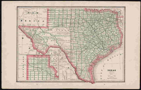
Sold2022Clean 1883 RR map of Texas, Geo. F. CramInteresting cerographic map of Texas from Cram’s Unrivaled Family Atlas of the World. Predates subdivision of Tom Green, Pecos, Crockett and Presidio Counties. Shows rail system throughout statSee Sold Price
Sold2023Large Brass 1628 World Map Wall Art by MasketeersThis impressive piece of wall art is a reproduction of a 1628 world map, created by Masketeers, Inc. in 1963. Measuring a substantial 43 1/2" by 30 1/2", it is a striking addition to any space. CrafteSee Sold Price
Sold2022THE ATLANTA CAMPAIGN CIVIL WAR MAPTHE ATLANTA CAMPAIGN CIVIL WAR MAP. PLEASE VIEW ALL DETAILED PICTURES. PRINTED TO LOOK LIKE THE ORIGINAL. A GREAT FIND AND AN EXCELLENT ADDITION TO YOUR COLLECTION.See Sold Price
Sold2022(12) Vol. 1967 -1968 volume set of Le Grande Atlas facsimile addition Published in AmsterdamThe 3rd. Centenary Addition of Johan Blaeu's Cosmographies, Complete 12 Vol. Set in original slip Covers and boxes. Incls: 609 Double Page Maps (Some in Color)  Published by Theatrvm OrSee Sold Price
Sold2017Homann: Map of France, 17421742 Homann France: Regni Galliae Seu Franciae Et Navarrae. A detailed map of France colored to show the political subdivisions. Great deal of topographical and settlement details are provided. The maSee Sold Price
Sold202219th C. Map of New YorkMap of New York dated 1890, showing political divisions and subdivisions November 1870, gilt framed under glass. [Art: 17" H x 38" W; Frame: 25 1/2" H x 47" W]. In good condition.See Sold Price
5 days LeftZikorn Arts & History ObjectsWest Indies, Eastern Cuba 1881 British Admiralty Nautical Map$100
3 days LeftJasper521858 Mitchell Map of Great Britain and Ireland [verso] Germany and Switzerland -- No. 22 Map of$25
3 days LeftJasper521858 Mitchell Map of Southern Europe and France [verso] Asia -- No. 24 Map of France, Spain,$30
4 days LeftLos Angeles Modern AuctionsChristo, Wrapped Trees (Project for Avenue des Champs-Elysees, Paris)$5,000
Jun 02Schilb Antiquarian Rare Books1844 Sparks American Biography Zebulun PIKE US Military Voyages 5v USA$1
3 days LeftFleischer's Auctions1755 Map Partie de l'Amerique Septentrionale, qui comprend Le Cours de L'Ohio...$200(3 bids)
1 hr LeftCrescent City Auction GalleryWilliam H. Williams (1817-1886), New Orleans "Map of the Sixth District and Carrollton," 1871, H.-$650
1 day LeftSchilb Antiquarian Rare Books1977 JRR Tolkien 1st ed 1st Printing Silmarillion Lord of the Rings + MAP + DJ$200(5 bids)
1 day LeftSchilb Antiquarian Rare Books1883 FLORIDA for Tourists & Settlers Illustrated Fort Barrancas MAP Fine BINDING$90(5 bids)
1 day LeftSchilb Antiquarian Rare Books1859 AFRICA VOYAGES Barth Timbuktu Tripoli SLAVES Illustrated Slavery MAP African$105(5 bids)
May 18Blackstone Valley Auctions & Estates LLCRevolutionary Era War Map of the Attack on Ft. Moultrie.$120(2 bids)


![Original Map of Daly Addition Annex, Butte [151280]: Original map of Daly Addition Annex in Butte, Named after Marcus Daly of Copper King Mine. 8.5x11", hand colored lots. Corner chip, creases with reverse tape and pencil writing.Date: Country (if not U](https://p1.liveauctioneers.com/2699/254728/132473498_1_x.jpg?height=310&quality=70&version=1657577698)


![19th C. Map of New York: Map of New York dated 1890, showing political divisions and subdivisions November 1870, gilt framed under glass. [Art: 17" H x 38" W; Frame: 25 1/2" H x 47" W]. In good condition.](https://p1.liveauctioneers.com/1221/251963/131695197_1_x.jpg?height=310&quality=70&version=1656475639)


![1858 Mitchell Map of Great Britain and Ireland [verso] Germany and Switzerland -- No. 22 Map of (1 of 2)](https://p1.liveauctioneers.com/5584/328338/176911589_1_x.jpg?height=282&quality=70&version=1715113718)
![1858 Mitchell Map of Southern Europe and France [verso] Asia -- No. 24 Map of France, Spain, (1 of 2)](https://p1.liveauctioneers.com/5584/328338/176911601_1_x.jpg?height=282&quality=70&version=1715113718)


