Sold20191831 McNeill Map of the Very Early New England RailroadTitle/Content of Map: 1831 McNeill Map of the Very Early New England Railroad Plans -- Map Exhibiting the Several Routes Surveyed for a Proposed Rail Road from Boston to Providence and also to TauntonSee Sold Price
Sold2022Exceptional map of Johnson's Texas, 1866Authentic and impressive vintage map of Texas. A highly desirable map that details the state in full. Shows the elevated Table Lands, the U. S. Mail Route, the Staked Plain (El Llando Estadado), numerSee Sold Price
Sold2016Erin (dates unknown) Imperial Airways Routes Map,Erin (dates unknown) Imperial Airways Routes Map, printed by Curwen Press May 1938 - 63 x 101 cm; and Imperial Airways Alexandria - Durban, Booklet containing maps of route taken by Flying Boats, withSee Sold Price
Sold2024Eight Gulf, Mobile & Ohio Railroad Playing Card Decks - Alton Route Map and LogoEight Gulf, Mobile & Ohio Railroad Playing Card Decks - Alton Route Map and LogoA group of eight playing card decks for Gulf, Mobile & Ohio Railroad almost completely unopened in original cellophane pSee Sold Price
Sold2020Mille Miglia Route map from the XI Mille Miglia 1937With all control points, 2 pages dirtySee Sold Price
Sold2020SOUTHERN STATES TRADE ROUTE MAPLarge Framed Trade Route Map showing waterways and towns from the Mississippi River to Charles Town. Geographic Area Covered: Southern States, South Carolina,Santee River Valley, Savannah River ValleySee Sold Price
Sold2020Post Route Map of California and Nevada (109790)Post Route Map of the States of California and Nevada, dated September 1907. Paper map glued to a canvas backing attached to a wooden rod at the top. Lower left corner of the map has been damaged andSee Sold Price
Sold20222 American Drawings Ship Route Map Salmagundi Club2 American 19th Century Drawings: a hand drawn Ship Route Map in pencil by Charles H Miller MD of the Ship Harvest Queen on a 1864 voyage from New York City to Liverpool, the verso with various map noSee Sold Price
Sold2021Impressive map of Louisiana, O. W. Gray, 1875Title: Impressive map of Louisiana, O. W. Gray, 1875 Description: Great vintage hand colored map of this beautiful Gulf state. Wonderful detailing of the southern marshy areas along the coast, and nicSee Sold Price
Sold2023Scarce 1850 RR and steamboat route map of Alabama“A New Map of Alabama with its Roads & Distances from Place to Place along the Stage and Steamboat Routes.” Fascinating map of this southern state from an exceedingly scarce atlas (dated 1850See Sold Price
Sold2016Greyhound Lines Bus Route Map Poster, 1937Approx. 30" x 20". Not linen backed. Rolled. Some light edge and corner wear, small edge tears.See Sold Price
Sold20191950s PanAm Route Map of Caribbean -- PanAmericanTitle/Content of Map: 1950s PanAm Route Map of Caribbean -- PanAmerican Flight Map of New York and Caribbean Date: late 1950s c. Cartographer: PanAm Size: 14x 24 in. folded out A very nice route map oSee Sold Price
Sold20231891 Nautical Steamship Route MapUnited States,1891 Map detailing routes for steamships titled "Tracks for Full Powered Steam Vessels" published by the Hydrographic Office, Navy Department, Washington D.C. in 1891. Pint on paper laidSee Sold Price
Sold20201950s PanAm Route Map of Caribbean -- Pan AmericanTitle/Content of Map: 1950s PanAm Route Map of Caribbean -- Pan American Flight Map of New York and Caribbean Cartographer: PanAm Year/Place: late 1950s c. Size: 24 X 14 in. folded out A very nice rouSee Sold Price
Sold2023Delaware and Hudson RR Framed Bridge Line Route Map 1823-1973This large framed poster/map is from the Delaware and Hudson Railroad and shows their routes for both canal and railroad from 1823 to 1973, between New England and Canada. An excellent, full color pieSee Sold Price
Sold2018Vintage Hawaiian Airline Route Map of Hawaii, 1953Title/Content of Map: 1953 Hawaiian Airline Route Map of Hawaii -- Hawaiian Airline Map of the State of Hawaii Date Printed: 1953 Cartographer: Hawaiian Airline Size: 9.2 x 21 in This is a very nice mSee Sold Price
Sold20221950s PanAm Route Map of Caribbeanan -- PanAmerican Flight Map of New York and CaribbeananTitle: 1950s PanAm Route Map of Caribbeanan -- PanAmerican Flight Map of New York and Caribbeanan Cartographer: PanAm Year / Place: late 1950s c. Map Dimension (in.): 14x 24 in. folded out A very niceSee Sold Price
Sold20221950s PanAm Route Map of Caribbean -- Pan American Flight Map of New York and CaribbeanTitle: 1950s PanAm Route Map of Caribbean -- Pan American Flight Map of New York and Caribbean Cartographer: PanAm Year/Place: late 1950s c. Dimensions: 24 X 14 in. folded out Description: A very niceSee Sold Price
Sold20211950s PanAm Route Map of Caribbeanan -- PanAmericanTitle: 1950s PanAm Route Map of Caribbeanan -- PanAmerican Flight Map of New York and Caribbeanan Cartographer: PanAm Year / Place: late 1950s c. Map Dimension (in.): 14x 24 in. folded out A very niceSee Sold Price
Sold20231950s PanAm Route Map of South America's East Coast -- Pan American Flight Map, South America EastTitle: 1950s PanAm Route Map of South America's East Coast -- Pan American Flight Map, South America East Coast Cartographer: PanAm Year / Place: late 1950s c. Map Dimension (in.): 23.5 X 16.8 in. folSee Sold Price
Sold20181950s PanAm Route Map of Caribbeanan -- PanAmericanTitle/Content of Map: 1950s PanAm Route Map of Caribbeanan -- PanAmerican Flight Map of New York and Caribbeanan Date: late 1950s c. Cartographer: PanAm Size: 14x 24 in. folded out A very nice route mSee Sold Price
Sold2024Vintage Chicago and Northwestern System Train Route MapSome tattered edges. Map measures 15 x 21 3/4 inches , frame measures 18 1/4 x 24 1/4 inchesSee Sold Price
Sold20191950s PanAm Route Map of Caribbean -- PanAmericanTitle/Content of Map: 1950s PanAm Route Map of Caribbean -- PanAmerican Flight Map of New York and Caribbean Date: late 1950s c. Cartographer: PanAm Size: 14x 24 in. folded out A very nice route map oSee Sold Price
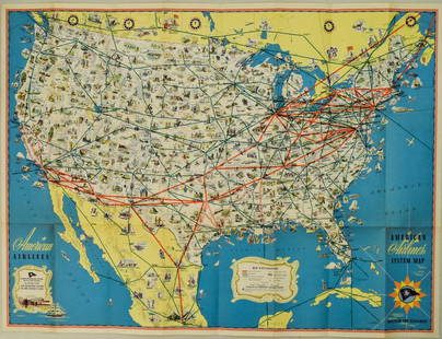
Sold20221940s American Airlines US Route Map -- American Airlines System MapTitle: 1940s American Airlines US Route Map -- American Airlines System Map Cartographer: American Airlines (General Drafting Co.) Year / Place: 1940s c. Map Dimension (in.): 24 X 32 in. Ths is an attSee Sold Price
May 09Rail & Road Auctions1951 Chicago, Milwaukee, St. Paul & Pacific Railroad Wall Map - Route of the Hiawathas$50
5 days LeftJasper521723 Dampier Map of Voyages to Brazil, Australia and Eat Indies -- Voyage du Cap. Dampier a la N.$280
5 days LeftJasper521865 Colton Map of US Southwest -- Colton's Map of California, Nevada, Utah, Colorado, Arizona & New$160
May 16Zikorn Arts & History ObjectsWest Indies, Providence, Windward, Cuba 1834 British Admiralty Map$100(1 bid)


![[Maps] American Atlas, Folio (1 of 14)](https://p1.liveauctioneers.com/3532/326332/175680379_1_x.jpg?height=282&quality=70&version=1713151485)


