Sold2019Rare map of Switzerland’s Neufchâtel region and city.Title/Content of Map: Rare map of Switzerland’s Neufchâtel region and city. Date: 1717 Cartographer: Feuille Size: 7.6x10.6” Provenance: Amsterdam Original hand color Reserve: $65.00 Shipping: DoSee Sold Price
Sold2019Rare map of Belgium’s Hainaut region with two cityTitle/Content of Map: Rare map of Belgium’s Hainaut region with two city views Date: 1717 Cartographer: Feuille Size: 7.6x10.6” Provenance: Amsterdam Additional Info: Original hand color Reserve:See Sold Price
Sold2019Rare map of the Wallonia region of Belgium with cityTitle/Content of Map: Rare map of the Wallonia region of Belgium with city views of Brussels and other cities. Date: 1717Cartographer: by FeuilleSize: 7.6x10.6” Provenance: Amsterdam original hand cSee Sold Price
Sold2019Rare map of French region of Lunguedoc with 12 cityTitle/Content of Map: Rare map of French region of Lunguedoc with 12 city views including Montpelier. Date: 1717 Cartographer: Feuille Size: 7.6x10.6” Provenance: Amsterdam Additional Info: OriginalSee Sold Price
Sold2021RARE map of Thrace region and BulgariaTitle: RARE map of Thrace region and Bulgaria Date/Period: 1596 Materials: Copperplate engraved Size: 14" x 10 1/4" Shows the region where modern Turkey, Greece and Bulgaria converge. With large partsSee Sold Price
Sold2023A rare city map of 1912 San FranciscoA rare city map of 1912 San Francisco, the map was reproduced in 1968 by First Savings and Loan Association commemorating the opening of the First Savings building at Sansome, San Francisco, 14.7"x22"See Sold Price
Sold2021Portugal, RARE Swedish issue by A. Akerman 1768-1774.Title: Portugal, RARE Swedish issue by A. Akerman 1768-1774. Date/Period: 1768-1774 Materials: Copperplate engraved Size: 7 1/2 x 6”. Rare map shows the regions of Portugal in different color boSee Sold Price
Sold2021Greece. RARE Swedish issue by A. Akerman 1768-1774Title: Greece. RARE Swedish issue by A. Akerman 1768-1774 Date/Period: 1768-1774 Materials: Copperplate engraved Size: 7 1/2 x 6” Rare map shows the regions of Greece in different color outlines. 17See Sold Price
Sold2023VERY RARE WALL MAP OF THE CITY OF BANGOR,PENOBSCOT COUNTY, MAINE. 1853, Bangor, Maine. "Published Under the Patronage of the City Government Henry F. Walling, Civil Engineer, 81 Washington St. Boston 1853". "S.S. Smith, Publisher 17 West MarSee Sold Price
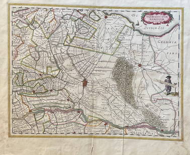
Sold2023The Netherlands Map. The region Around the city of Utrecht. 1660?s by W. BlaeuTitle: The Netherlands Map. The region Around the city of Utrecht. 1660?s by W. Blaeu Date/Period: 1660?s Materials: Hand colored copper plate engraved Size: 22 x 19 1/2'' Netherlands regional map cenSee Sold Price
Sold2022Rare J.H. Colton Map, Southern Regions, Antarctica, South PoleRare mid 19th Century map of Southern Regions, Antarctica, South Pole, The Southern Polar Regions by J. H. Colton, from an 1855 first edition, Colton's Atlas of The World. A rare look at Antarctic expSee Sold Price
Sold2022Europe. RARE Swedish issue by A. Akerman 1768-1774Title: Europe. RARE Swedish issue by A. Akerman 1768-1774 Date/Period: 1768-1774 Materials: Copperplate engraved Size: 7 1/2 x 6” Rare Map of this popular region. 1768-1774. By Anders Akerman. RSee Sold Price
Sold2022Laminated Unique Media New York City MapLaminated Unique Media "New York City And Region" Map. The map is approx 27" x 18 1/4" and it weighs 0.29lb. The map is in a good, used condition with light creases and scratches. Please see the imageSee Sold Price
Sold20231850 NEW YORK City MAP Almanac Broadway RARE The Great Metropolis1850 NEW YORK City MAP Almanac Broadway RARE The Great Metropolis ‘The Great Metropolis’ is a 19th-century annual periodical on the state of New York. This work contains descriptions of iSee Sold Price
Sold20241850 NEW YORK City MAP Almanac Broadway RARE The Great Metropolis1850 NEW YORK City MAP Almanac Broadway RARE The Great Metropolis The Great Metropolis is a 19th-century annual periodical on the state of New York. This work contains descriptions of iconic buildingsSee Sold Price
Sold2022Rare Ide's Map Of Missoula, Montana City 1891Featured in this lot we have a rare large map of Missoula Montana, 1891. Compiled and drawn by Kennedy & Powell Civil and mining engineers in Missoula, engraved by J.L. Smith, Philadelphia, PA. (as wrSee Sold Price
Sold2020RARE 1596 map of Rhine Palatinate regionTitle: RARE 1596 map of Rhine Palatinate region Date/Period: 1596 Materials: Copperplate engraved Size: 14" x 10 1/4" Description: This is a rarer variation of Quads map of the region. The portrait isSee Sold Price
Sold2016Rare Seagears Map of the Catskill RegionTitled "The Angler's Guide to 1,500 square miles of America's most concentrated trout fishing by Clayton B. Seagears, 1935, measuring unfolded 21 3/4" x 28'. Covering the big five rivers, being the NeSee Sold Price
Sold2019Rare map of Hungry with 20 city viewsTitle/Content of Map: Rare map of Hungry with 20 city views Date: 1717 Cartographer: Feuille Size: 7.6x10.6” Provenance: Amsterdam Additional Info: Original hand color. Reserve: $70.00 Shipping: DSee Sold Price
Sold2019Rare map of Catalonia with 13 city views includingTitle/Content of Map: Rare map of Catalonia with 13 city views including Barcelona Date: 1717Cartographer: by FeuilleSize: 7.6x10.6” Provenance: Amsterdam original hand color Reserve: $95.00 ShippinSee Sold Price
Sold2017Bellin: Antique Map of Mexico City Region, 1754Map: Carte des Environs de la Ville de Mexico Cartographer: Bellin Place & Date: Paris / 1754 Size: 6 3/4" x 8 3/4" Condition: outline color; overall age toning Bellin's detailed map of the environs oSee Sold Price
Sold2019Rare map of Provence, France, with multiple city views.Title/Content of Map: Rare map of Provence, France, with multiple city views. Including Avignon, Nice, Marseille Date: 1717 Cartographer: Feuille Size: 7.6x10.6” Provenance: Amsterdam Original hanSee Sold Price
Sold2018Bellin: Antique Map of Ancient Mexico City Region, 1760Map: Karte von dem See von Mexico Cartographer: Bellin / Arkstee&Merkus Place & Date: Leipzig / 1760 Size: 5 7/8" x 7 7/8" Condition: b&w; overall age toning and light browning Bellin's detailed map oSee Sold Price
Sold2024Exceptional 18th Century Map of The Carolinas, Maryland and VirginiaBy Johann Baptist Homann, Germany, late 17th/early 18th century. Hand colored map of the region which is excellent and quite rare. The map giving excellent details of the region and having exquisite eSee Sold Price
Jun 12Dan Morphy AuctionsPHELPS’S TRAVELERS GUIDE THROUGH THE UNITED STATES; CONTAINING UPWARDS OF SEVEN HUNDRED$1,000
Jun 07Freeman's | HindmanMURCHISON, Roderick Impey, Sir. The Silurian System. 1839. COMPLETE WITH VERY RARE HAND-COLORED$1,500
1 day LeftJasper521720 Homann Map of the Caspian Sea Region -- Provinciarum Persicarum Kilaniae nempe Chirvaniae$220
2 days LeftMynt AuctionsRare 1935 New York to San Francisco via Panama Canal Postcard to Waconia MN$310
Jun 06Freeman's | HindmanCONRAD, Joseph (1857-1924). Victory. An Island Tale. Garden City, NY: Doubleday, Page & Company,$1,000
1 day LeftJasper521593 de Jode Maps of Eastern Germany (Saxony Area) and Western Germany -- Mansfeldiae Comitatus ...$700
Jun 23Schilb Antiquarian Rare Books1855 San Francisco 1st ed California Gold Rush Illustrated MAPS Soule Indians$11(3 bids)
5 days LeftTrillium Antique Prints & Rare BooksBraun & Hogenberg, pub. 1575 - View of Delft, Netherlands$100
5 days LeftTrillium Antique Prints & Rare BooksBraun & Hogenberg, pub. 1575 - View of Ostia, Italy$100(1 bid)
5 days LeftTrillium Antique Prints & Rare BooksBraun & Hogenberg, pub. 1575 - Views in the Middle East: Aden, Mombasa, Kilwa, & Sofala$100(1 bid)