Sold20192V ANNUAL REPORTS OF THE FOREST FISH AND GAME2V ANNUAL REPORTS OF THE FOREST FISH AND GAME COMMISSIONER OF THE STATE OF NEW YORK 1897 1907-1909 Illustrated Chromolithograph Fish Animals Map Adirondack Denton Gillette Maple Syrup This auction lotSee Sold Price
Sold2017New York State MapNew York State Map ca. 1940 paper/linen/wood/metal 48.13" W x 1.75" D x 64.75" H Vintage New York social studies map manufactured by Denoyer-Geppert Co. of Chicago, IL, with working pull-down mechanisSee Sold Price
Sold20231846 Framed "A New Map of New York" State MapHand colored map by Mitchell of 1846. Drawn on French marble paper, hand finished frame with gold leaf. Frame measures approximately 24.5" x 22.25". Estimated shipping cost for this auction lot is $50See Sold Price
Sold2018NEW YORK STATE MAP, J.H. FRENCH 1860NEW YORK STATE MAP, J.H. FRENCH 1860 W. 73 1/2" H. 64"See Sold Price
Sold2017Johnson: New York State Map, 1866Map: 1866 Johnson's New York State Map -- Johnson's New York Cartographer: A Johnson & Co. Year/Place: 1866 New York Dimensions: 17 x 24 in. This is a large double page map of New York state with muchSee Sold Price
Sold20221866 Johnson's New York State Map -- Johnson's New YorkTitle: 1866 Johnson's New York State Map -- Johnson's New York Cartographer: Johnson and Ward Year / Place: 18656, New York Map Dimension (in.): 16.8 x 25 This is an excellent double page map of New YSee Sold Price
Sold2018Johnson: Antique New York State Map, 1865Title/Content of Map: 1865 Johnson's New York State Map -- Johnson's New York City, Brooklyn, Jersey City, Hoboken, Etc Date Printed: 1865 New York Cartographer: A Johnson & Co. Size: 16.8 x 25 This iSee Sold Price
Sold2021Antique New York State Map 1903 Color Roll Up RR Map1903 Scarborough's New Railroad, Post Office, Township and County Map of New York. Color map, compiled from the latest government and state surveys and original sources of the era. Insets: Map of NewSee Sold Price
Sold2022Scarce early Cram RR map of New YorkExceedingly scarce New York state map from the last Cram atlas to feature hand colored maps. “New Railroad and County Map of New York” from the very scarce 1882 Cram’s Unrivaled FamSee Sold Price
Sold2018Thomas, Cowpwerthwait: Antique Map of New York, 1854Title/Content of Map: 1854 Thomas, Cowpwerthwait Map of New York State -- Map of the State of New York Compiled from the Latest Authorities Date Printed: 1854 Philadelphia Cartographer: Thomas, CowperSee Sold Price
Sold2018Group of New York State Historical MapsGroup of New York State Historical Maps. Map of Orleans County, NY, 1852 (40" x 47"); Map of Village of Albion, NY, 1857 (40" x 47"); Map of the State of New York, 1833 (21" x 25 1/2").. The RochesterSee Sold Price
Sold20231841 1ed New York State HUGE MAP Historical Collections Albany NYC Buffalo1841 1ed New York State HUGE MAP Historical Collections Albany NYC Buffalo A scarce first edition printing of the antebellum historical treatise, Historical Collections of the State of New York. CollaSee Sold Price
Sold201619th c. New York State Pocket MapLate 19th c. New York State 9 ½” (height) x 12” (length) colored fold-up pocket map set into a 5” (height) x 2 ½” booklet which on the front cover reads United States Hotel Easton, PennsylvaSee Sold Price
Sold2023Group lot of NEW YORK State Topographical MapsGroup lot of NEW YORK State Topographical Maps, maps measure 17 x 21 inches, wear consistent with age and use. not framed. Art, wall art, artwork, home decor, maps, topographic, topography, New York SSee Sold Price
Sold2022Group lot of NEW YORK State Topographical MapsGroup lot of NEW YORK State Topographical Maps, maps measure 17 x 21 inches, wear consistent with age and use. not framed. Art, wall art, artwork, home decor, maps, topographic, topography, New York SSee Sold Price
Sold2017Richmond: Antique Map of New York State Canals, 1858Title/Content of Map: 1858 Richmond map of the New York State Canals -- Map and Profiles of New-York State Canals Date Printed: 1858, Albany Cartographer: Van R Richmond Size: 22.8 x 39.8 in. A very iSee Sold Price
Sold2022Adirondack Map 1908Adirondack Maps 1908 New York State 3 Maps Present - Southeast - Northwest - Northeast Publisher State of New York Dated: 1908 Condition Report GoodSee Sold Price
Sold2017EARLY NEW YORK STATE ACTUAL SURVEY MAPEARLY NEW YORK STATE ACTUAL SURVEY MAP FOR COUNTIES ALONG SUSQUAHANNAH RIVER, INCL. CLINTON, CHENANGO, GREEN, ETC. 18TH C. 15 1/2" X 21"See Sold Price
Sold2017Williams: Antique Pocket Map on New York State, 1828Map: 1828 Williams Pocket Map on New York State -- The Tourist's Map of the State of New York Compiled from the Latest Authorities in the Surveyor General's Office Cartographer: W. Williams Year / PlaSee Sold Price
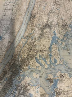
Sold2019Johnson's New York Maps [New York State, NYC]Two Johnson's New York Maps, one of New York City and Brooklyn, the other of New York State. Alvin Jewett Johnson Cartographer. Published by A. J. Johnson, New York. Stamped 'Entered according to ActSee Sold Price
Sold2022LOT/7 19TH CEN. HISTORICAL MAPS NEW YORK STATE & OTHERSLOT/7 19TH CEN. HISTORICAL MAPS NEW YORK STATE & OTHERSSee Sold Price
Sold2017Scott Hanson, mixed mediaScott Hanson, mixed media, Scott Hansen (American, 20th/21st c.), "New York State of Arts", 2003, map of New York State composted out of NY State license plates mounted onto steel plaque, signed, dateSee Sold Price
Sold2020SMITH, J. CALVIN. Map of the State of New York.SMITH, J. CALVIN. Map of the State of New York. Engraved map of New York state with three inset maps. 19¾x25¼ inches sheet size; hand-colored in outline; issued folding, now flat and mountedSee Sold Price
Sold2022Automobile Blue Book Vol.1 1920 [150277]Softcover. The Automobile Blue Book of New York state and Canada. Many maps and touring info. 1068pp.Date: Country (if not USA): State: New YorkCity: Provenance: Stuart Mackenzie Montana Ephemera CollSee Sold Price
3 days LeftJasper521867 Beers Map of New York City Area -- Map of New York and Vicinity Accompanying "Atlas of New York$200
6 days LeftRail & Road Auctions1912 and 1913 Electric Railway Journal Encyclopedias Volume 40 and 42$40
6 days LeftRail & Road Auctions1908 and 1909 Street Railway Journal Encyclopedias Volume 31 and 33$40
6 days LeftRail & Road Auctions1926 and 1928 Electric Railway Journal Encyclopedias Volume 68 and 71$40
6 days LeftRail & Road Auctions1924 and 1925 Electric Railway Journal Encyclopedias Volume 63 and 66$40
6 days LeftRail & Road Auctions1911 and 1912 Electric Railway Journal Encyclopedias Volume 37 and 39$40
Aug 07Joe R. Pyle Complete Auctions & Real EstateNew York Times May 3, 1931 Prohibition Act states liquor still seizures map$5
5 days LeftA.H. Wilkens Auctions & AppraisalsHARPER'S PICTORIAL HISTORY OF THE CIVIL WAR (1866)CA$150
Jul 06Case Antiques, Inc. Auctions & AppraisalsColton's Atlas of the World, 1856, in Two Volumes; plus Africa / Mahdist War Map$500(1 bid)
2 days LeftActivity Auctions1866 History Of The Romans by Merivale Fine Leather Bindings Rare Lg Foldout Map$1,100


![Johnson's New York Maps [New York State, NYC]: Two Johnson's New York Maps, one of New York City and Brooklyn, the other of New York State. Alvin Jewett Johnson Cartographer. Published by A. J. Johnson, New York. Stamped 'Entered according to Act](https://p1.liveauctioneers.com/5755/154409/77936949_1_x.jpg?height=310&quality=70&version=1573094011)


![Automobile Blue Book Vol.1 1920 [150277]: Softcover. The Automobile Blue Book of New York state and Canada. Many maps and touring info. 1068pp.Date: Country (if not USA): State: New YorkCity: Provenance: Stuart Mackenzie Montana Ephemera Coll](https://p1.liveauctioneers.com/2699/258191/134291066_1_x.jpg?height=310&quality=70&version=1660351799)


