Sold2020SMITH, J. CALVIN. Map of the State of New York.SMITH, J. CALVIN. Map of the State of New York. Engraved map of New York state with three inset maps. 19¾x25¼ inches sheet size; hand-colored in outline; issued folding, now flat and mountedSee Sold Price
Sold2016Traveling map of U.S. by J. Calvin Smith 1849Heading: Author: Smith, John Calvin Title: A New Map for Travelers through the United States of America, Showing the Railroads, Canals & Stage Roads Place Published: New York Publisher:Sherman & SmitSee Sold Price
Sold2020J. Calvin Smith Guide Through Ohio... mapSmith, J. Calvin- ''Guide through Ohio, Michigan, Indiana, Illinois, Missouri, Wisconsin & Iowa'', New York: published by J. H. Colton, 1856, engraved map with hand-coloring folding pocket map. (red cSee Sold Price
Sold20231842 MATHER & SMITH WALL MAP OF LONG ISLAND, NYHand-colored lithograph. "A Geological Map of Long & Staten Islands with the Environs of New York"; William W. Mather, geologist and J. Calvin Smith, surveyor. This landmark pre-Civil War map is the eSee Sold Price
Sold2020The State of New York Map 1861J. H. French The State of New York Map, 1861, Robert Persoll Smith, Publisher. Has been shellacked, has significant cracking at the right edge, center bottom and top edge. Top bar is coming loose. MeaSee Sold Price
Sold2016A New Map for Travelers through the United States ofA New Map for Travelers through the United States of America, by John Calvin Smith, Sherman & Smith, New York, 1849, Framed {Dimensions of frame 23 1/4 x 27 1/4 inches}See Sold Price
Sold2024Hardin’s 1893 HERKIMER COUNTY & 1860 NY GAZETTEER.2 vols. French, J. H. Gazetteer of the State of New York. Syracuse: R. Pearsall Smith, 1860. Large octavo, orig. gilt-stamped leather-backed cloth boards, engraved steel plates, lacks folding map. SpiSee Sold Price
Sold2016The State of New Hampshire...John Reid & W. Winterbotham. from the American Atlas. New York: J. Reid, L. Wayland & C. Smith, 1796. Engraved Map with Orignal Hand-color in Outline. 16 1/4 x 19 1/4 inchesSee Sold Price
Sold2018NEW YORK STATE MAP, J.H. FRENCH 1860NEW YORK STATE MAP, J.H. FRENCH 1860 W. 73 1/2" H. 64"See Sold Price
Sold2020Railroad & Township Map of New YorkHeading: Author: Colton, J.H. Title: Colton's Railroad & Township Map of the State Of New York. With Parts of the Adjoining States & Canada Place Published: New York Publisher:Colton & Company DSee Sold Price
Sold20242 19th Century New York Maps Gamble & Colton2 19th century maps of New York. Colton's Map of New York and the Adjacent Cities, J.H. Colton 1855, 16 1/4" x 26 1/4" (with frame 28 1/8" x 38"); County Map of the State of New York, W.H. Gamble, 187See Sold Price
Sold2017Map of the State of New York by J. DenisonCirca 1796 Antique Map, Title: Map of the State of New York by J. Denison. A. Doolittle (sculp.) Approximate size: 10-5/8" x 8-3/8". Please note that this lot has a confidential reserve. When you leavSee Sold Price
Sold2017Smith: Antique Railroad Map of the United States, 1855Map: Map of the United States of America, Showing the Rail Roads. Large, Colorful Railroad Map of U.S. 1855 Publication Date: 1855 Authors: HARPER & BROTHERS, SMITH, J. CALVIN / D. MCLELLAN Publisher:See Sold Price
Sold2022J.H. COLTON (1800-1893) A MAP, "New Map of the State ofJ.H. COLTON (1800-1893) A MAP, "New Map of the State of Texas," NEW YORK, CIRCA 1855, hand-colored lithograph on paper, "Compiled from J. de Cordova's large Map," and, "Published by J.H. Colton & Co.,See Sold Price
Sold2022Colored 1827 map of New York with Erie Canal and another.Map of the State of New York, published by A. Finley, Philad[elphi]a, 1827. J. H. Young, sc. Strong thin paper map, hand colored as issued, showing the Erie Canal (completed little more than one yearSee Sold Price
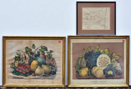
Sold2020Two Currier & Ives PrintsAutumn Fruits and Summer Fruits each 15 1/2" x 19" stone lithographs and a Map of the State of New York by J. Denison, published by Thomas & Andrews, Boston, 1796See Sold Price
Sold2018J. H. Colton's Map of United StatesIncluding US, British Provinces, Mexico, and West Indies. Published by J.H. Colton, New York, 1853. 59" x 53".See Sold Price
Sold2019Johnson's New York Maps [New York State, NYC]Two Johnson's New York Maps, one of New York City and Brooklyn, the other of New York State. Alvin Jewett Johnson Cartographer. Published by A. J. Johnson, New York. Stamped 'Entered according to ActSee Sold Price
Sold2023An 1860 Map of New York State by J.H. French and an 1846 Mitchell's Reference & Distance Map of theAn 1860 Map of New York State by J.H. French and an 1846 Mitchell's Reference & Distance Map of the United States by J.H. Young58 x 72 1/2 inchesOther Notes: Fontaine's Auction Gallery can arrange shiSee Sold Price
Sold2017LOT (3) EARLY POCKET BOOK MAPS C.1830'sLOT (3) EARLY POCKET BOOK MAPS INCL. H/C STATE OF NEW YORK BY HUMPHREY PHELPS,1833, 16" X 21", STATE OF NEW JERSEY BY J. LOW, C. 1830, 10 1/2" X 7 1/2", STATE OF PENNSYLVANIA BY A. FINLEY, C. 1830, 9"See Sold Price
Sold20191855 Colton Map of New York -- New YorkTitle: 1855 Colton Map of New York -- New York Date: 1855, New York Cartographer: J Colton Size: 11.8 X 14.7 in. Additional Information: This is a very nice map of New York state with the insets of NeSee Sold Price
Sold2019J. Calvin Smith, "Colton's The United States ofJ. Calvin Smith, "Colton's The United States of America," 16 Maps comprising the wall map of the United States, 1853, paper mounted on linen, Each- H. - 16 in., W. - 20 1/4 in.See Sold Price
Sold2020Early United States Roll-Up MapEarly United States roll-up map. Published by J. H. Colton / New York / 1853. 44 1/2" x 36".See Sold Price
Sold2022(RAILROADS.) J.W. Orr. Map of the All-Rail Great Southern Mail Route.(RAILROADS.) J.W. Orr. Map of the All-Rail Great Southern Mail Route. Small lithographed map of railroad connections from New York to the southern states printed in blue with an inset table of distancSee Sold Price
May 15University ArchivesAl Smith Signed Photo with Churchill Just Weeks After Car Accident$100(1 bid)
1 day LeftPapps Family Liquidation1.16 Ctw SI2/I1 Diamond 14K White Gold Express your Country/ state love New York Necklace$500
Freeman's | HindmanDIPLOMACY | A group of 8 works, most FIRST EDITIONS INSCRIBED TO ALBRIGHT.$225(7 bids)
7 days LeftSchilb Antiquarian Rare Books1869 American Emigrants Immigration Illustrated US State MAPS Railroad Alaska$1(1 bid)
2 days LeftJasper521775-1780. New York, New Jersey, Pennsylvania, Maryland, Virginia and New England states. By Bonne &$120
May 16Potter & Potter AuctionsBOURNE, Emma (1906 – 1986). America – A Nation of One Peopl...$125(1 bid)


![Colored 1827 map of New York with Erie Canal and another.: Map of the State of New York, published by A. Finley, Philad[elphi]a, 1827. J. H. Young, sc. Strong thin paper map, hand colored as issued, showing the Erie Canal (completed little more than one year](https://p1.liveauctioneers.com/1066/241373/125137826_1_x.jpg?height=310&quality=70&version=1648068277)

![Johnson's New York Maps [New York State, NYC]: Two Johnson's New York Maps, one of New York City and Brooklyn, the other of New York State. Alvin Jewett Johnson Cartographer. Published by A. J. Johnson, New York. Stamped 'Entered according to Act](https://p1.liveauctioneers.com/5755/154409/77936949_1_x.jpg?height=310&quality=70&version=1573094011)


![[WWI] P.T. Sherman's WWI Service Record & Books (1 of 8)](https://p1.liveauctioneers.com/7226/322253/173251586_1_x.jpg?height=282&quality=70&version=1710004847)


