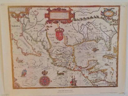
Sold20231600s Map of the New World drawn by Gabriel Tatton & engraved by Benjamin WrightMeasurements:With frame- 20" x 25.75"Without frame- 17.75" x 22.75"Weight- 5 lb. A portion of the proceeds from Lots 1-40 are going to the Gibbes Museum of Art in memory of Katherine M. Huger**ShippinSee Sold Price
Sold2017Gabriel Tatton: Map of The New World, 1600The New World Map. 1600. Drawn by Gabriel Tatton. Engraved by Benjamin Wright. 24 x 18 inches. Please note that this lot has a confidential reserve. When you leave a bid in advance of the auction, subSee Sold Price
Sold2017Gabriel Tatton: The New World Map, 1600The New World Map 1600” drawn by Gabriel Tatton - reproduction by American Heritage, the magazine of history. Measurement approximate: 24” x 18”. Condition: Very Good Please note that this lSee Sold Price
Sold2021Tallis, John (Pub) 1852 Map. New ZealandSteel Engraved Map with Original Outline Hand Color Published 1852-56 by John Tallis, London for "The Universal Pronouncing Dictionary" by Thomas Wright. Drawn & Engraved by John Rapkin. Centre fold aSee Sold Price
Sold2021Tallis, John (Pub) 1852 Map. New South Wales, AustraliaSteel Engraved Map with Original Outline Hand Color Published 1852-56 by John Tallis, London for "The Universal Pronouncing Dictionary" by Thomas Wright. Drawn & Engraved by John Rapkin. Centre fold aSee Sold Price
Sold2020Rapkin, John 1860 Map. World HemispheresSteel Engraved Map Published 1860 by The London Printing & Published Company, London for "The Royal Dictionary-Cyclopedia for Universal Reference" by Thomas Wright. Drawn & Engraved by John Rapkin. FoSee Sold Price
Sold2022Rapkin, John 1860 Map. World on Mercators ProjectionSteel Engraved Map Published 1860 by The London Printing & Published Company, London for "The Royal Dictionary-Cyclopedia for Universal Reference" by Thomas Wright. Drawn & Engraved by John Rapkin. FoSee Sold Price
Sold2020Rapkin, John 1860 Map. World on Mercator's ProjectionSteel Engraved Map Published 1860 by The London Printing & Published Company, London for "The Royal Dictionary-Cyclopedia for Universal Reference" by Thomas Wright. Drawn & Engraved by John Rapkin. FoSee Sold Price
Sold2022Rapkin, John 1860 Antique Map. World HemispheresSteel Engraved Map Published 1860 by The London Printing & Published Company, London for "The Royal Dictionary-Cyclopedia for Universal Reference" by Thomas Wright. Drawn & Engraved by John Rapkin. FoSee Sold Price
Sold2020Rapkin, John 1860 Map. World on Mercator's ProjectionSteel Engraved Map Published 1860 by The London Printing & Published Company, London for "The Royal Dictionary-Cyclopedia for Universal Reference" by Thomas Wright. Drawn & Engraved by John Rapkin. FoSee Sold Price
Sold2020Rapkin, John 1860 Antique Map of New ZealandSteel Engraved Map Published 1860 by The London Printing & Published Company, London for "The Royal Dictionary-Cyclopedia for Universal Reference" by Thomas Wright. Drawn & Engraved by John Rapkin. FoSee Sold Price
Sold2021Tallis, John (Pub) 1852 Map East Canada & New BrunswickSteel Engraved Map with Original Outline Hand Color Published 1852-56 by John Tallis, London for "The Universal Pronouncing Dictionary" by Thomas Wright. Drawn & Engraved by John Rapkin. Centre fold aSee Sold Price
Sold2019Rapkin, John 1860 Map of the World HemispheresSteel Engraved Map Published 1860 by The London Printing & Published Company, London for "The Royal Dictionary-Cyclopedia for Universal Reference" by Thomas Wright. Drawn & Engraved by John Rapkin. FoSee Sold Price
Sold2021FRAMED J.H. COLTON MAP OF NORTH AMERICA CA INSETFramed engraving on paper, Map of North America from the Latest Authorities, published by J.H. Colton (Joseph Hutchins Colton, 1800-1893), No. 86 Cedar St., New York, 1846, drawn and engraved by J.M.See Sold Price
Sold2022(NEW ORLEANS.) Benjamin Moore Norman. Norman's Plan of New Orleans & Environs.(NEW ORLEANS.) Benjamin Moore Norman. Norman's Plan of New Orleans & Environs. Finely detailed hand-colored engraved pocket map of New Orleans with an 86-point keyed reference panel. 17¾x24½See Sold Price
Sold2022Voyages.- Dampier (William) A New Voyage Round the World, first edition, for James Knapton, 1697.NO RESERVE Voyages.- Dampier (William) A New Voyage Round the World, first edition, 5 engraved maps (4 folding), folding frontispiece wormed at lower margin, some marginal foxing or light soiling, inkSee Sold Price
Sold2024Coronelli's elegant two-sheet hemispheric world map[MAP - WORLD] CORONELLI, VINCENZO MARIA. Planisfero Del Mondo Vecchio; [and] Planisfero Del Mondo Nuovo. [Venice: circa 1691]. Two hand-colored engraved hemispheric world maps printed on separate sheeSee Sold Price
Sold2024Petrus Plancius, Engraved World MapOrbis Terrarum Typus de Integro Multis in Locis Emendatus. Petrus Plancius (1552-1622). Copper-plate engraving with original hand color in full. Amsterdam, 1594. Some stains, creases, folds. Sight sizSee Sold Price
2022Blaeu, Johannes (Netherlands, 1596-1673) "The New World Map" Double Hemisphere World Map C. 1664Nova et Accuratissima Totius Terrarum Orbis Tabula Translated "The New World Map", Hand Colored w/ Elaborately Decorated Spandrels.   Sight View 16" x 21-1/2", Overall View 21" x 25-1/2"See Sold Price
Sold2017First printed plan of New Haven, showing Yale CollegeA plan of the town of New Haven : with all the buildings in 1748...William Lyon (fl. c. 1800-1806). Engraved map. New Haven: T. Kensett, 1806. 28 1/4 x 20 1/2 inches sheet. The Kensett map is the firsSee Sold Price
Sold2022ORTELIUS, ABRAHAM. Typus Orbis Terrarum.ORTELIUS, ABRAHAM. Typus Orbis Terrarum. Double-page engraved map of the world. 16¾x20½ inches sheet size, wide margins, Dutch text on verso; original hand-color; professionally conserved wiSee Sold Price
Sold2023Mercator, Rumold (1545-1599) World MapAn engraved double-page double hemispheric world map, "Orbis Terrae Compendiosa Descriptio". Dimensions:Sight is 11 1/4" x 20 3/4", the frame 21" x 29 1/2". Provenance:From a Philadelphia Collection.See Sold Price
Sold2022World.- Speed (John) A New and Accurat Map of the World Drawne according to ye truest DescriptionsWorld.- Speed (John) A New and Accurat Map of the World Drawne according to ye truest Descriptions latest Discoveries & best observations yt have beene made by English or Strangers, double-hemisphereSee Sold Price
Sold2022MITCHELL, S. AUGUSTUS. A New Map of Texas, Oregon and California.MITCHELL, S. AUGUSTUS. A New Map of Texas, Oregon and California. Engraved pocket map of the American territories west of the Mississippi River. 22¾x21 inches overall, ample margins; strong origiSee Sold Price
May 14Akiba Galleries(2 Pc) Allain Manesson Mallet Description De L'Univers 2 Vol. German Translation$200(1 bid)
3 days LeftTremont AuctionsJohn Speed and Francis Lamb "Map of New England and New York", ca. 1676. Hand colored engraved map$900(3 bids)
2 days LeftTrillium Antique Prints & Rare BooksMitchell's A New Universal Atlas.. - Volume with 73 Maps$1,000(1 bid)
May 14Fleischer's Auctions1755 Map Partie de l'Amerique Septentrionale, qui comprend Le Cours de L'Ohio...$200(3 bids)
May 16Ma San AuctionTHREE ANTIQUARIAN MAPS ON CHINA. 'The Great Imperial Throne from Le Comte', Beijing. G. CHILD£50


![Coronelli's elegant two-sheet hemispheric world map: [MAP - WORLD] CORONELLI, VINCENZO MARIA. Planisfero Del Mondo Vecchio; [and] Planisfero Del Mondo Nuovo. [Venice: circa 1691]. Two hand-colored engraved hemispheric world maps printed on separate shee](https://p1.liveauctioneers.com/292/326828/175962847_1_x.jpg?height=310&quality=70&version=1713473479)


![[Daguerreotype] Revolutionary War & War of 1812 Hero (1 of 4)](https://p1.liveauctioneers.com/7226/322253/173251484_1_x.jpg?height=282&quality=70&version=1710004847)
![[WWI] P.T. Sherman's WWI Service Record & Books (1 of 8)](https://p1.liveauctioneers.com/7226/322253/173251586_1_x.jpg?height=282&quality=70&version=1710004847)


