Sold2023Frederik De Wit Map of Hungary and the Balkans.This antique hand-colored map is matted and mounted to a cardstock backing. The map is dated 1686, and is accredited to Frederici (Frederik) de Wit. The text is in Latin. It looks to be in overall gooSee Sold Price
Sold2022(5) ANTIQUE MAPS, MERCATOR & DE WITT, 17TH C.(lot of 5) Antique maps, early 17th c., published by Gerardus Mercator (Belgian, 1512-1594), likely from the "Mercator Hondius Atlas," published after his death c.1619, and Fredeick De Witt (Dutch, 16See Sold Price
Sold2023Antique Map Print - Frederick de Witt - Map of The Kingdom of Denmark - EuropeTitle/Artist: Antique Map Print - Frederick de Witt - Map of The Kingdom of Denmark - Europe Date/Period: 1690 Material: Paper Dimensions: 56 cm x 67 cm Description: The Kingdom of Denmark, ComprisingSee Sold Price
Sold2023Antique Map of Ireland, Frederick de WittDutch, 1629-1706..REGNI et INSULAE HIBERNIAE, latter 17th century, hand colored copper plate engraving, sight 28 x 19.5 in..toning, areas of foxing and discoloration, creases, under glass, not examineSee Sold Price
Sold20211690 ANTIQUE MAP OF LIMBURG NETHERLANDS by Frederik de1690 ANTIQUE MAP OF LIMBURG NETHERLANDS TABULA DUCATUS LIMBURCH ET COMITATUS VALCKENBURCH IN LUCEM EDITA A.F.WIT Copper-plate engraved map printed on laid paper,hand colored, no text on the verso By FSee Sold Price
Sold2022Antique French Map of AfricaAntique French Map of Africa. "Carte de L'Afrique..."by J. Andriveau-Goujon, Paris, dated 1841. Framed. Ex. Collection William and Diane Bousquette, Purchase, New York. Size: 15'' x 19.5'', 38 x 50 cmSee Sold Price
Sold20201666 Pas-Caart van Guinea en de Custen daer aen gelegenThis is an authentic antique map of the western coast of Africa. The map was published by Pieter Goos in his atlas De Zee-Atlas, Ofte Water-Weereld… out of Amsterdam. With an easterly orientatioSee Sold Price
Sold2018Mallet: Antique Map of Central Italy, Papal States 1683Title of the Map: 'Estat Ecclesiastique et Duche de Toscane' Shows the Papal States & the Duchy of Tuscany. Rome. Tuscany and Central Italy. Date Printed: 1683 Image Size: Approx Overall page size 13See Sold Price
Sold20164 Maps: 1760 N. Am.; Botanic Geo.; Eur.; OK Terr.Four Antique Maps; a French 1760 Map of North American ''AMÉRIQUE SEPTENTRIONALE...1750'' Paris: S. Robert De Vaugondy, c. 1750 (1st edition, dated in the cartouche; "Outlines of Botanical Geography"See Sold Price
Sold2018ANTIQUE ICON & ANTIQUE PARIS ITINERARY MAPHand painted icon signed & dated 1832 - 12.25" h x 9.25" w plus antique Carte Routiere De Dion-Bouton Environs De Paris itinerary mapSee Sold Price
Sold2018ANTIQUE ICON & ANTIQUE PARIS ITINERARY MAPHand painted icon signed & dated 1832 - 12.25" h x 9.25" w plus antique Carte Routiere De Dion-Bouton Environs De Paris itinerary mapSee Sold Price
Sold2023Brion Map of East AsiaLouis Brion de la Tour, French, 1743-1803. An 18th century engraved map with hand-coloring, titled "Chine, et Indes avec les Isles". Signed "par M. Brion" and dated "1766" in the plate lower left. MinSee Sold Price
Sold2022[MAPS]. A group of maps, comprising: [MAPS]. A group of maps, comprising:  DeWITT, Frederick. Insula sive Regnum Siciliae. -- FONTAINIER, Girard. Le Theatre d'Eau dans les Jardins de Versailles. -- De'L'ISLE. Carte du Gouvernement GSee Sold Price
Sold2021Antique Map of Malta by Frederico de Wit, 19" x 22Antique Map of Malta by Frederico de Wit, 19" x 22 1/2".See condition report.See Sold Price
Sold2019AN ANTIQUE MAP, "Poli Arctici et CircumiacentiumAN ANTIQUE MAP, "Poli Arctici et Circumiacentium Terrarum Descriptio Novissima," CIRCA 1676, hand colored engraving on paper, published by Frederick de Wit (1630-1706), a banner cartouche U/L, "GedrucSee Sold Price
Sold2019AN ANTIQUE MAP, "Accuratissima Angliæ Regni et WalliæAN ANTIQUE MAP, "Accuratissima Angliæ Regni et Walliæ Principatus," AMSTERDAM, CIRCA 1680, hand colored engraving on paper, published by Frederick de Wit (1630-1706), showing most of the British IslSee Sold Price
Sold2021De Witt. Angliae Regni et Walliae Principatus.[England] de Witt, Frederick (1630-1706). "Accuratissima Angliae Regni et Walliae Principatus." Amsterdam. c.1680. Copperplate engraved map. Hand colored cartouche and bordering. Shows most of the BriSee Sold Price
Sold2023De Wit Map of Zeeland, HollandDE WIT, Frederick (c. 1630-1706). Comitatus Zelandiae tabula... Engraved map with original hand color. Amsterdam, c. 1680. 21 1/2" x 24 3/8" sheet, approx. Antique Map of Zeeland, Netherlands showingSee Sold Price
Sold20223x Antique mapThree antique maps. 17th - 18th century. 1x La Gueldre, Pierre van de Aa, 1659 - 1733, discolored. 1x Zuthpen belaying, by Don Frederico MDLXIIXVI, hand colored. 1x Heerlijcheijt van Overrijssel, CL VSee Sold Price
Sold2018Frederick the Great MEMOIRES POUR SERVIR A L'HISTOIREFrederick the Great MEMOIRES POUR SERVIR A L'HISTOIRE DE LA MAISON DE BRANDEBOURG 1751 Antique History French Genealogy Explication Folding Maps Joachim II George Guillaume Frederic Guillaume Title: MSee Sold Price
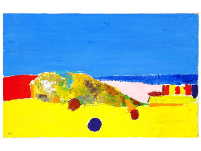
Sold2024FRENCH LANDSCAPE OIL PAINTING BY NICOLAS DE STAELNicolas De Stael, Russian, French, 1914 to 1955, oil painting on canvas depicting an abstract landscape composition, 1954. Signed, lower left. Additionally signed, dated, and inscribed, Aurigente, DriSee Sold Price
Sold2017Jaime de Guzman (Philippines b. 1942) oversized oil onJaime de Guzman (Philippines b. 1942) oversized oil on canvas, verso titled- GIFT OF FOSSILS, dated August 1969, oil size s59in. X 56in. Signed and dated lower right.See Sold Price
Sold2024WILLEM DE KOONING Lithograph FIGURES IN LANDSCAPE VI 88/100 Signed de Kooning '80. signed, dated andWILLEM DE KOONING Lithograph FIGURES IN LANDSCAPE VI 88/100 Signed de Kooning '80. signed, dated and numbered in pencil. Consigned from original owners Dimensions: Height: 40.5 inches, Width: 36.5 incSee Sold Price
Sold20222 Picasso Lithographs, Dance of Youth & Carnet de la CalifornieTwo (2) Pablo Picasso (Spanish, 1881-1973) color lithographs. 1st item: Picasso lithograph titled "Dance of Youth" depicting abstract multi-color figures dancing around a dove. Signed and dated in theSee Sold Price
4 days LeftTrillium Antique Prints & Rare BooksPrevost - Map of Japan with part of Korea and China$50
May 18RbfineartsBritish-Anthony De Brie1854-1921 Oil On Canvas Portrait Of A Thoroughbred Horse$100(1 bid)
7 hrs LeftJasper521748 ARCHITECTURE TREATISE on THERMAL WATERS antique ILLUSTRATED w/10 ENGRAVINGS$260
7 hrs LeftJasper521726 FACTORUM DICTORUMQUE V. MAXIMUS ANTIQUE w/ HAGUE COAT OF ARMS VELLUM LATIN$320
May 20Kensington Estate AuctionJane Freilicher (American, 1924-2014) COSMOS & MALLOWS, 1965$375(2 bids)


![[MAPS]. A group of maps, comprising: : [MAPS]. A group of maps, comprising:  DeWITT, Frederick. Insula sive Regnum Siciliae. -- FONTAINIER, Girard. Le Theatre d'Eau dans les Jardins de Versailles. -- De'L'ISLE. Carte du Gouvernement G](https://p1.liveauctioneers.com/197/256567/133425974_1_x.jpg?height=310&quality=70&version=1659179184)


![De Witt. Angliae Regni et Walliae Principatus.: [England] de Witt, Frederick (1630-1706). "Accuratissima Angliae Regni et Walliae Principatus." Amsterdam. c.1680. Copperplate engraved map. Hand colored cartouche and bordering. Shows most of the Bri](https://p1.liveauctioneers.com/179/209052/106367558_1_x.jpg?height=310&quality=70&version=1624651037)