Sold2016Venezuela, Arnoldus Montanus 1671Title: Venezuela cum parte Australi Novae Andalusiae Subject: Venezuela Maker: Arnoldus Montanus Date: 1671, Amsterdam Size: 11.4 x 14.25 inches From Montanus' "De Nieuwe en Onbekende Weereld: of BescSee Sold Price
Sold202317th c map of Venezuela, Hondius/BlaeuVenezuela. Hondius/Blaeu, Venezuela, cum Parte Australi Novae Andalusiae, from Novus Atlas, 1647. Dimensions:The sheet is 19" x 23". Provenance:From a Main Line collection.See Sold Price
Sold2023Ogilby / Montanus Map of the AmericasOGILBY, John (1600-1676) / MONTANUS, Arnoldus (c. 1625–1683). Insulae Americanae in Oceano Septentrionali cum Terris adiacentibus. Engraved map. London, 1671 (Second state). 16" x 20 1/2" sheet, 33"See Sold Price
Sold2017Hondius: Antique Map of Venezuela, 1630Map: Venezuela, Cum Parti Novae Andalusiae." Publication Date: 1630 ca. Authors: H. HONDIUS, HONDIUS, HENRICUS (1597-1651)/E. S. HAMERSVELDT/S. ROGERIUS Publisher: H. HONDIUS Size: Folio – 14.75 H xSee Sold Price
Sold20201671 Montanus Map of Very Early Virginia -- NovaTitle/Content of Map: 1671 Montanus Map of Very Early Virginia -- Nova Virginiae Tabula Cartographer: A. Montanus / J. Ogilby Year/Place: 1671 c Size: 14.1 x 11.5 in. This is an outstanding decorativeSee Sold Price
Sold2021Montanus 1671 Map of Mexico & Central AmericaDESCRIPTION: Map by cartographer Montanus extending to Costa Rica, based off cartographer Gerritsz's work. Title cartouche is bright and colorful reading "NOVA HISPANIA NOVA GALICIA GUATIMALA" and depSee Sold Price
Sold2017ANTIQUE MAP OF ISLE OF JAVA, JAN JANNSON 17TH CFramed engraved and colored map, " Insulae Iavae cum Parte Insularum Borneo Sumatrae, et circumjacentium insularum novissima delineatio", map of Isle of Java, possibly mid-late 17th c., by Jan JanssonSee Sold Price
Sold20201671 Montanus/Ogilby Map of Chile -- ChiliTitle/Content of Map: 1671 Montanus/Ogilby Map of Chile -- Chili Cartographer: Montanus/Ogilby Year/Place: 1671, London Size: 11.2 X 14.2 in. This is a very attractive map covering the coastal regionSee Sold Price
Sold2017Montanus / Ogilby: Antique Map of Central America, 1671Map: Yucatan . . . et Guatimala Cartographer: Montanus / Ogilby Place & Date: Amsterdam / 1671 Size: 14 1/4" x 11 1/4" Condition: b&w; overall age toning and some spotting The detailed map of southeasSee Sold Price
Sold2019Montanus / Ogilby: Antique Map of Central America, 1671The detailed map of southeastern Mexico and Central America from Ogilby's English edition of Montanus' influential history of America. The map encompasses the Mexican heartland, the Yucatan peninsula,See Sold Price
Sold2023An important historical map by Montanus and Ogilby depicting New York, New England, and Virginia,An important historical map by Montanus and Ogilby depicting New York, New England, and Virginia, published in 1671. This map from a Jansson-Visscher map of the Northeast, extending from the St. LaureSee Sold Price
Sold2018Montanus/Ogilby: Atahualpa, Last Inca Emperor 1671Map: Athabaliba Cartographer: Montanus / Ogilby Place & Date: London / 1671 Size: 6 1/2 " x 11" Condition: b&w; light overall age-toning and some staining mostly in the margins The dramatic portrait oSee Sold Price
Sold2023MAP, Mexico, MontanusAcapulco, Mexico. Montanus/Ogilby, Portus Acapulco, from America, 1671 (circa). Black & White. This attractive copper engraved view of Acapulco and its bay is a nice rendering of the town, with fortifSee Sold Price
Sold2021MAP, Itamaraca, Brazil, MontanusItamaraca, Brazil. Arnoldus Montanus, I. Tamaraca, from De Nieuwe en Onbekende Weereld, 1671 (circa). Black & White. This fine view shows the Dutch Fort Oranje on the island of Itamaraca, off the nortSee Sold Price
Sold2017Montanus/Ogilby: Antique View of Acapulco, 1671Map: Portus Acapulco Cartographer: Montanus / Ogilby Place & Date: London / 1671 Size: 13 3/4" x 11 1/4" Condition: wash color; light overall age toning A dramatic and beautifully colored bird's eye vSee Sold Price
Sold2017Nova Mexico folding map from American 1671 by OgilbyOgilby, John, 1600-1676, Montanus, Arnoldus, 1625?-1683, Nova Mexico from Novissima et Accuratissima Totius Americae Descriptio.11 x 21.25 inches, America: Being The Latest, And Most accurate DescriptSee Sold Price
Sold2019MAP - Guyana, Suriname, French Guiana. MontanusGuyana, Suriname, French Guiana. Montanus/Ogilby, Guiana sive Amazonum Regio, 1671 (circa). Hand Color. This decorative map covers the region from the Isla Margarita in the northwest to the coast of nSee Sold Price
Sold2022Nova Hispania Nova Galicia Guatimala. 1671.[Map/South America] Ogilby, John; Montanus Arnoldus. Nova Hispania Nova Galicia Guatimala. 1671. Hand colored copperplate engraved map. Framed: This map, based on the cartography of Hessel Gerritsz, iSee Sold Price
Sold2018Montanus / Ogilby Novi BelgiMontanus, Petrus (1595-1638) & Ogilby, John (1600-1676). Nova Belgii Quod Nunc Novi Jork Vocatur... Engraved map with original color. J. Ogilby, 1671. 11 ½" x 14 ½" sheet. Centering on Long IslaSee Sold Price
Sold2016Insulae Americanae, Arnoldus Montanus 1671Title: Insulae Americanae in Oceano Septentrionali, cum Terris adiacentibus Subject: Caribbean Islands Maker: Arnoldus Montanus Date: 1671, Amsterdam Size: 11.2 x 14.25 inches From Montanus' "De NieuwSee Sold Price
Sold2016Il Canal Grande a Ca' Pesaro.Michele Marieschi , Il Canal Grande a Ca' Pesaro - Pisaurorum Familiae Aedes ad Canalis magni marginem, una cum D: Eustachij templo dextrorsum, et sinistrorsum cum parte Corneliorum aedis. 1770 ca. AcSee Sold Price
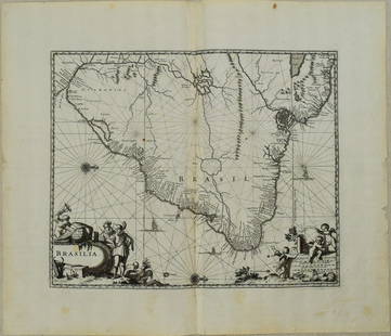
Sold20231671 Ogilby Map of Brazil -- BrasiliaTitle: 1671 Ogilby Map of Brazil -- Brasilia Cartographer: J Ogilby Year / Place: 1671, London Map Dimension (in.): 11.3 X 13.8 in. This is an excellent map of the eastern part of Brazil. There is anSee Sold Price
Sold202417C. Willem & Jan Blaeu Map of VenezuelaWillem & Jan Blaeu Netherlands 17th Century Hand colored map of Venezuela and the lower Antilles created by Willem Blaeu and Jan Blaeu with glass back to feature atlas pages. Lithograph on paper,ImageSee Sold Price
Sold2021Peru by Arnoldus Montanus, 1671, AmsterdamTitle: Peru by Arnoldus Montanus, 1671, Amsterdam Date/Period: 1671 Materials: Copperplate engraved Size: 17x15 1/4”. Peru, shows the viceroyalty with all present day Peru, Ecuador and parts of BoliSee Sold Price
3 days LeftRiverfront Auctions"Arx Carolina" hand-colored engraving by Arnold Montanus c. 1671$100(1 bid)
10 hrs LeftSwann Auction Galleries(NEW ENGLAND.) Arnoldus Montanus; or John Ogilby. Novi Belgii Quod Nunc Novi Jorck Vocatur, Novae qe$450
10 hrs LeftSwann Auction Galleries(RUSSIA.) Vincenzo Maria Coronelli. Moscovia Parte Orientale / Parte Occidentale.$450
2 days LeftTrillium Antique Prints & Rare BooksDe Jode, Rare, pub. 1593 - Map of Islands including Sicily, Corsica, Sardinia, Cyprus, Candia,$100(1 bid)
2 days LeftTrillium Antique Prints & Rare BooksDe Jode, Rare, pub. 1593 - Maps of the Baltic, North Sea & Russia (Livoniae Provinciae Ac Eivs /$100
10 hrs LeftSwann Auction Galleries(AMERICAS.) Giovanni Battista Ramusio. Universale Della Parte del Mondo Nuovamente Ritrovata.$1,900
10 hrs LeftSwann Auction Galleries(MERCATOR/HONDIUS.) Group of 19 double-page engraved atlas maps.$375


![Nova Hispania Nova Galicia Guatimala. 1671.: [Map/South America] Ogilby, John; Montanus Arnoldus. Nova Hispania Nova Galicia Guatimala. 1671. Hand colored copperplate engraved map. Framed: This map, based on the cartography of Hessel Gerritsz, i](https://p1.liveauctioneers.com/179/268856/140616119_1_x.jpg?height=310&quality=70&version=1668545725)