Sold2017Nova Mexico folding map from American 1671 by OgilbyOgilby, John, 1600-1676, Montanus, Arnoldus, 1625?-1683, Nova Mexico from Novissima et Accuratissima Totius Americae Descriptio.11 x 21.25 inches, America: Being The Latest, And Most accurate DescriptSee Sold Price
Sold20231671 Ogilby Map of Panama and Northern South America -- Terra Firma et Novum Regnum Granatense etDescriptionTitle: 1671 Ogilby Map of Panama and Northern South America -- Terra Firma et Novum Regnum Granatense et PopayanCartographer: J OgilbyYear / Place: 1671, LondonMap Dimension (in.): 11.3 X 1See Sold Price
Sold2021Montanus 1671 Map of Mexico & Central AmericaDESCRIPTION: Map by cartographer Montanus extending to Costa Rica, based off cartographer Gerritsz's work. Title cartouche is bright and colorful reading "NOVA HISPANIA NOVA GALICIA GUATIMALA" and depSee Sold Price
Sold2024John Ogilby 1671 Antique "Nova Virginiae Tabula" Pencil Signed Hand Colored Virginia MapAntique 1671 hand-colored and pencil-signed "Nova Virginiae Tabula" map of Virginia and Chesapeake region. In good overall condition, with age-appropriate wear. Approx. image size 11 1/4" x 14". ApproSee Sold Price
Sold2023MAP, Mexico, MontanusAcapulco, Mexico. Montanus/Ogilby, Portus Acapulco, from America, 1671 (circa). Black & White. This attractive copper engraved view of Acapulco and its bay is a nice rendering of the town, with fortifSee Sold Price
Sold2018Montanus / Ogilby Novi BelgiMontanus, Petrus (1595-1638) & Ogilby, John (1600-1676). Nova Belgii Quod Nunc Novi Jork Vocatur... Engraved map with original color. J. Ogilby, 1671. 11 ½" x 14 ½" sheet. Centering on Long IslaSee Sold Price
Sold2019Montanus / Ogilby: Antique Map of Central America, 1671The detailed map of southeastern Mexico and Central America from Ogilby's English edition of Montanus' influential history of America. The map encompasses the Mexican heartland, the Yucatan peninsula,See Sold Price
Sold2022Nova Hispania Nova Galicia Guatimala. 1671.[Map/South America] Ogilby, John; Montanus Arnoldus. Nova Hispania Nova Galicia Guatimala. 1671. Hand colored copperplate engraved map. Framed: This map, based on the cartography of Hessel Gerritsz, iSee Sold Price
Sold2020Map, John OgilbyJohn Ogilby (British, 1600-1676), "Nova Hispania Nova Galicia Guatimala (with part of Florida and Cuba)," 1671, hand-colored engraving, sight (image): 14"h x 11.5"w, overall (with mat/unframed): 17.5"See Sold Price
Sold2020Pierre Duval Nova Mexico Map ca. 1660 CaliforniaPierre Duval (1618-1683), "Nova Mexico," Nuremberg, ca. 1660-1680. This rare map depicts California as an island, based on Sanson's depiction, along with the surrounding areas of Mexico and what is noSee Sold Price
Sold20201671 Montanus/Ogilby Map of Chile -- ChiliTitle/Content of Map: 1671 Montanus/Ogilby Map of Chile -- Chili Cartographer: Montanus/Ogilby Year/Place: 1671, London Size: 11.2 X 14.2 in. This is a very attractive map covering the coastal regionSee Sold Price
Sold2021New Mexico177. New Mexico.Graham, James D. Report...on the Subject of a Boundary Line between the United States and Mexico. 2 folding maps, folding chart. 8vo, removed; remnants of leather on spine, generally sSee Sold Price
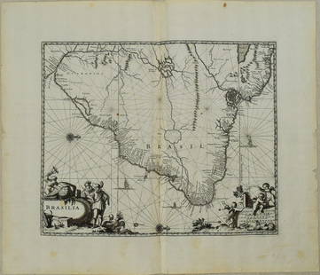
Sold20231671 Ogilby Map of Brazil -- BrasiliaTitle: 1671 Ogilby Map of Brazil -- Brasilia Cartographer: J Ogilby Year / Place: 1671, London Map Dimension (in.): 11.3 X 13.8 in. This is an excellent map of the eastern part of Brazil. There is anSee Sold Price
Sold2019Group of Five Early 20th Century History Books.Group of Five Early 20th Century History Books. Includes: Harmon’s Journals by Daniel Williams Harmon (1903, folding map); Taxation in American States and Cities by Richard T. Ely (1888, first eSee Sold Price
Sold2019Group of Early Maps of New Mexico(1) Rand, McNally & Co.'s New Commercial Atlas of America - Map of New Mexico. Copyright, 1911, by Rand, McNally & Co. 23 3/4 x 31 1/4 inches (2) Geologic Map of New Mexico. Two-part folding map. PartSee Sold Price
Sold20171950 Map of PanAm Airline Caribbean Routes1950 Map of PanAm Airline Caribbean Routes -- Pan American Flight Map New York and Caribbean. PanAm, 1950 ca., A nice folding map of Pan American Airline routes to Caribbean from New York City & MiamiSee Sold Price
Sold2017Buchon: Antique Map of North & South America, 1825Title/Content of Map: 'Carte géographique, statistique et historique de l'Amerique' The North American map shows Mexico with its borders prior to the Mexican-American war, with its territory includinSee Sold Price
Sold202417C. Willem Blaeu Map of MexicoWillem Blaeu Netherlands 1571-1638 Map of Mexico titled "Nova Hispania et Nova Galicia" in a colored cartouche by Willem Blaeu, featuring a glass back to showcase the atlas pages. Lithograph on paper,See Sold Price
Sold20201950s Pan Am Flight Map of Mexico and Central AmericaTitle: 1950s Pan Am Flight Map of Mexico and Central America -- Pan American Flight Map of Mexico and Central America Date: 1950s Cartographer: Pan American Size: 17.5 x 24 in. folded out Additional ISee Sold Price
Sold20181957 Route Map of Pan American Airline to Mexico,Title/Content of Map: 1957 Route Map of Pan American Airline to Mexico, Central America and Part of Caribbean -- Pan American Flight Map [to] Mexico & Central America Date: 1957 Cartographer: PanAm SiSee Sold Price
Sold2024Nova Hispania Et Nova Galicia Map Of Mexico By BlaeuHand Colored, removed from an atlasSee Sold Price
Sold2024Very Rare Mexico Nova Hispania 1579 Hand Colored MapORTELIUS, Abraham (1527-1598). Theatrum Orbis Terrarum. 1570. It is considered to be the first modern atlas. Map of New Spain (Mexico), 1579. Printed in Antwerp by Christophe Plantin (1588). Etching.See Sold Price
Sold20231758 Folding Map of New England and Nova ScotiaA Map of New England and Nova Scotia with part of New York, Canada, and New Britain and the adjacent Islands of New Found Land and Cae Breton, by Thomas Kitchin, printed at London for London Magazine,See Sold Price
Sold2022Main currents of the American Mediterranean.Caribbean/Gulf of Mexico 1885 mapTITLE/CONTENT OF MAP: 'Main currents of the American Mediterranean' DATE PRINTED: 1885 IMAGE SIZE: Approx 9.0 x 11.0cm, 3.5 x 4.25 inches (Small) TYPE: Antique wood-engraved map; Scale 1:45,000,000 COSee Sold Price
7 days LeftJasper52Central America Caribbean Gulf of Mexico chart Ports lighthouses LARGE 1918 map$45
6 days LeftJasper521850 James Maps from Mexican-American War of Battle of Sacramento and Brazito, Map of Santa Fe and$80
7 days LeftJasper52CENTRAL AMERICA & CARIBBEAN. West Indies Mexico &c. Inset Panama Canal 1890 map$20
Featured7 days LeftJasper52MEXICO CENTRAL AMERICA WEST INDIES. Panama & Proposed Nicaragua canals 1912 map$35
Featured7 days LeftJasper52West India Islands & Central American States. Caribbean. STANFORD 1904 old map$60
7 days LeftJasper52West Indies. Caribbean islands Antilles Gulf of Mexico Florida. THOMSON 1830 map$150
Featured7 days LeftJasper52Carte du Golfe du Mexique et des Isles de l'Amerique' Caribbean BELLIN 1754 map$200
6 days LeftJasper521884 Rand McNally Map of US Railroad System -- Map Exhibiting the Several Pacific Railroads Prepared$140


![Nova Hispania Nova Galicia Guatimala. 1671.: [Map/South America] Ogilby, John; Montanus Arnoldus. Nova Hispania Nova Galicia Guatimala. 1671. Hand colored copperplate engraved map. Framed: This map, based on the cartography of Hessel Gerritsz, i](https://p1.liveauctioneers.com/179/268856/140616119_1_x.jpg?height=310&quality=70&version=1668545725)


![1957 Route Map of Pan American Airline to Mexico,: Title/Content of Map: 1957 Route Map of Pan American Airline to Mexico, Central America and Part of Caribbean -- Pan American Flight Map [to] Mexico & Central America Date: 1957 Cartographer: PanAm Si](https://p1.liveauctioneers.com/5584/124256/63192867_1_x.jpg?height=310&quality=70&version=1530636078)


