Sold20211720 c. Homann Map of Luxembourg -- Ducatus LuxemburgiTitle: 1720 c. Homann Map of Luxembourg -- Ducatus Luxemburgi tam in Maiores quam Minores Ejusdem Ditiones Accurate Distinctus et Exhibitus Cartographer: J Homann Year / Place: 1720 c., Nurnberg Map DSee Sold Price
Sold20201720 c. Homann Map of Poland, Lithuania to the BlackTitle/Content of Map: 1720 c. Homann Map of Poland, Lithuania to the Black Sea -- Regni Poloniae Magnique Ducatus Lithuaniae Nova et Exacta Tabula Cartographer: J Homann Year/Place: 1720 c. Nurnberg SSee Sold Price
Sold20211720 c. Homann Map of Czech Republic, Slovakia andTitle: 1720 c. Homann Map of Czech Republic, Slovakia and Poland -- Regni Bohemiae, Ducatus Silesiae, Marchionatus Moraviae et Lusatiae. Tabula Generalis Cartographer: J Homann Year / Place: 1720 c.,See Sold Price
Sold20221720 c. Homann Map of Czech Republic, Slovakia and Poland -- Regni Bohemiae, Ducatus Silesiae,Title: 1720 c. Homann Map of Czech Republic, Slovakia and Poland -- Regni Bohemiae, Ducatus Silesiae, Marchionatus Moraviae et Lusatiae. Tabula Generalis Cartographer: J Homann Year / Place: 1720 c.,See Sold Price
Sold20221720 c. Homann Map of Denmark -- Regni Daniae, in quoTitle: 1720 c. Homann Map of Denmark -- Regni Daniae, in quo sunt Ducatus Holsatia et Slesvicum, Insulae Danicae, Provinciae Iutia Scania Blekingia &c Nova Tabula Cartographer: J Homann Year / Place:See Sold Price
Sold2018Homann: Antique Map of Denmark, 1720Title/Content of Map: 1720 Homann Map of Denmark -- Regni Daniae in quo sunt Ducatus Holsatia et Slesvicum Insulae Danicae Provinciae Iutia Scania Blekingia Nova Tabula Date Printed: 1720 c Nurnberg CSee Sold Price
Sold20211720 c. Homann Map of Northern Poland to Lithuania --Title: 1720 c. Homann Map of Northern Poland to Lithuania -- Regnum Borussiae Gloriosis auspicys Serenissimi et Potentissimi Princ Friderici III Cartographer: J Homann Year / Place: 1720 c., NurnbergSee Sold Price
Sold20211720 c. Homann Map of Norteast Italy, Venice IncludedTitle: 1720 c. Homann Map of Norteast Italy, Venice Included -- Dominii Veneti cum vicinis Parme Mutinae Mantuae et Mirandole Statibus Cartographer: J Homann Year / Place: 1720 c., Nurnberg Map DimensSee Sold Price
Sold20201720 c. Homann Map of Benelux -- Tabula GeneralisTitle/Content of Map: 1720 c. Homann Map of Benelux -- Tabula Generalis Totius Belgii qua Provinciae XVII. Infer. Germaniae olim sub S.R.I. Circulo BurgundiaeÂ… Cartographer: J Homann Year/Place: 1See Sold Price
Sold20211720 c. Homann Map of Northern Poland to Lithuania --Title: 1720 c. Homann Map of Northern Poland to Lithuania -- Regnum Borussiae Gloriosis auspicys Serenissimi et Potentissimi Princ Friderici III Cartographer: J Homann Year / Place: 1720 c., NurnbergSee Sold Price
Sold20211720 c. Homann Map of Central Germany Near Fulda -- S.Title: 1720 c. Homann Map of Central Germany Near Fulda -- S. R. I. Principatus Fuldensis in Buchonia… Cartographer: J Homann Year / Place: 1720 c., Nurnberg Map Dimension (in.): 19.1 X 22.6 in. ThiSee Sold Price
Sold20201720 c. Homann Map of Paris and Surroundings -- AgriTitle: 1720 c. Homann Map of Paris and Surroundings -- Agri Parisiensis Tabula partieularis, qua maxima Pars Insulae Franciae, seu Regiae celeberrimaeq Parisiorum Urbis vicina Regio in fuas CastellaniSee Sold Price
Sold20201720 c. Homann Map of Belgium, Northern France andTitle/Content of Map: 1720 c. Homann Map of Belgium, Northern France and Western Germany -- Arena Martis in Belgio, Qua Provinciae X. Catholicae Inferioris Germaniae Cartographer: J Homann Year/Place:See Sold Price
Sold20201720 c. Homann Map of Central Germany's ThuringianTitle: 1720 c. Homann Map of Central Germany's Thuringian Forest Area -- Tabula Geographica in qua ... Principatus Gotha, Coburg et Altenburg Cartographer: J Homann Year/Place: 1720 c., Nurnberg DimenSee Sold Price
Sold2022Homann. Amplissimae Regionis Mississipi. c1720.[Map/America] Homann, Johannes Baptist. Amplissimae Regionis Mississipi. Nuremberg, c.1720. Hand colored copper-engraved map. Homann's important and widely disseminated map of the southeast of North ASee Sold Price
Sold20231720 Handcolored Homann Map TOTIUS AMERICAE SEPTENTRIONALIS ET MERIDIONALIS NOVISSIMA REPRAESENTATIOHistoric Maps Beautiful Hand-Colored Engraved Map by Johann Homann Titled: "TOTIUS AMERICAE SEPTENTRIONALIS ET MERIDIONALIS NOVISSIMA REPRAESENTATIO..." c. 1720 Hand-Colored Map titled, "TOTIUS AMERICSee Sold Price
Sold2022Johann Baptist Homann - 3 MapsAfrica, Asia and Europe Nuremberg, c. 1720 each 23"x19 1/2", framed 31"x28"See Sold Price
Sold2019Two Johann Baptist Homann (1661-1774) Maps, "VirginiaTwo Johann Baptist Homann (1661-1774) Maps, "Virginia Marylandia et Carolina in America Septatrionalis," c. 1720, hand colored, H.- 23 in., W.- 19 in. (2 Pcs.)See Sold Price
Sold2017J.B. Homann, 18th c. map of IrelandJ.B. Homann, 18th c. map of Ireland, Johann Baptist Homann (German,1664-1724), "Hiberniae Regnum tam in Praecipuas Ultoniae, Connaciae, Laceniae et Momoniae quam in Minores", c. 1720, 24"h x 20.5"w (sSee Sold Price
Sold2019Pomerania Central Europe Antique MapDucatus Pomeraniae. Hand-colored engraved map. J.B. Homann, Nuremberg, 18th C.. 21" x 24".See Sold Price
Sold20181581 Braun and Hogenberg View of Luxembourg --Title/Content of Map: 1581 Braun and Hogenberg View of Luxembourg -- Lutzenburgum, Ducatus eiusdem Nominis, Vetus et Primaria Urbs… Date: 1581 c., Koln Cartographer: Braun and Hogenberg Size: 13.6 XSee Sold Price
Sold2016Decprative world map 1720Heading: Author: Homann, Johann Baptiste Title: Planiglobii Terrestris cum Utroq Hemisphaerio Caelesti Generalis Exhibitio Place Published: Nuremberg Publisher: Date Published: c.1720See Sold Price
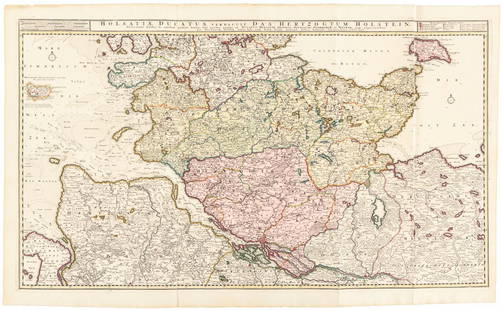
Sold2016Large map of Holstein, Germany 1720Heading: Author: Visscher, Nicolas Title: Holsatiae Ducatus Vernadule das Hertzogtum Holetein... Place Published: Amsterdam Publisher:Pieter Schenk, Jr. Date Published: c.1720 DescriptSee Sold Price
Sold2024MAP, France, HomannWestern France. Johann Baptist Homann, Tabula Ducatus Britanniae Gallis le Gouvernemt. General de Bretagne in suos Novem Episcopatus..., 1720 (circa). Hand Color. Large and very detailed chart roughlySee Sold Price
1 day LeftJasper521720 antique MAP of LOWER SAXONY GERMANY 18th CENT. Circulus Saxoniae inferioris$75
2 days LeftAdam's AuctioneersA GEORGE I WALNUT RECTANGULAR SIDE TABLE, C.1720 the white marble top on a tapering plain frieze on€750
6 days LeftTremont Auctions18th century map "Americae Septentrion" by Homann. Rarer early edition. Framed. Holes around outer$250(1 bid)
May 18Rich Penn AuctionsDecorative Art, map of South America, late 18th C., framed & matted, Exc cond, 24"H x 20"W overall.$50
Featured1 day LeftJasper52RARE MAP, 1762, 15 Cities of the Safavid era Persian Empire by J. B. Homann$600


![Homann. Amplissimae Regionis Mississipi. c1720.: [Map/America] Homann, Johannes Baptist. Amplissimae Regionis Mississipi. Nuremberg, c.1720. Hand colored copper-engraved map. Homann's important and widely disseminated map of the southeast of North A](https://p1.liveauctioneers.com/179/268856/140616121_1_x.jpg?height=310&quality=70&version=1668545725)