Sold20231794 Map Depicting Battle of Saunder's Creek- A "Disastrous Defeat" for the Revolutionaries1794 Map Depicting Battle of Saunder's Creek- A "Disastrous Defeat" for the Revolutionaries An engraved map of the "Plan of the Battle Fought near Camden [South Carolina], August 16th, 1780" producedSee Sold Price
Sold2023Scarce 1818 Map depicting the Battle of Bunker Hill drawn by witness Henry DeBernier, a soldier inScarce 1818 Map depicting the Battle of Bunker Hill drawn by witness Henry DeBernier, a soldier in the 10th regiment of infantry. "Sketch of the Action on the Heights of Charlestown 17 June 1775 BetweSee Sold Price
Sold2022H.M.S. AJAX CAPTAIN'S MAP OF THE BATTLE OF THE RIVER PLATEOriginal map depicting the Battle of the River Plate, 37 x 29 in. coated linen map fabric, prepared by Capt. Douglas H. Everett, commander of the H.M.S. AJAX only days after the December 13, 1939 engaSee Sold Price
Sold2022Rare First American Revolutionary War Battle MapAmerican Revolution First American Printing Of A Revolutionary War Battle Map "A View of the Present Seat of War, at and near New-York." 1777-Dated (Printed 1776) Revolutionary War Period, Printed MapSee Sold Price
Sold2023First American Revolutionary War Battle Map, from Nathan Daboll, Freebetter's New-England Almanacks,American Revolution First American Printing of a Revolutionary War Battle Map Titled: "A VIEW of the Present Seat of War, at and near New-York." by Nathaniel Low, Printed by John Gill, Boston 1777-DatSee Sold Price
Sold20211777 1st American Rev War Battle Map: SEAT of WARAmerican Revolution First American Printing Of A Revolutionary War Battle Map "A View of the Present Seat of War, at and near New-York." [1776] Revolutionary War Printed, First American printed RevoluSee Sold Price
Sold2022Faden Map of the Battle of Hobkirk's Kill, Revolutionary War, 1781FADEN, William (1749 – 1836). Sketch of the Battle of Hobkirks Hill, near Camden on the 25th April, 1781. Engraved map. London: Faden, Aug. 1, 1783. 21 3/4" x 15 1/8" sheet. This RevolutionarySee Sold Price
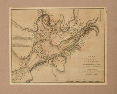
Sold20211780 Faden Map of American Revolutionary War Battle inTitle: 1780 Faden Map of American Revolutionary War Battle in Vermont -- Plan of the Action at Huberton Under Brigadier Genl. Frazer, Supported by Major Genl. Reidesel, on the 7th July 1777 CartographSee Sold Price
Sold2015Mill Creek Studios "Field of Battle" SculptureMill Creek Studios "Field of Battle" Sculpture, depicting two stags locking antlers in competition, resin construction, signed "Danny D. Edwards, 2000", 32.5" x 10" x 19.5"See Sold Price
Sold2017Revolutionary War Map of the Battle of SaratogaAmerican Revolution 1780 Revolutionary War Map Engraved by William Faden 1780-Dated Revolutionary War, Hand-Colored Map entitled, “Plan of the Encampment and Position of the Army Under His Excelly.See Sold Price
Sold2024REVOLUTIONARY WAR PAINTING - BATTLE IN SQUARE19th century oil on canvas attr. American, depicting an 18th century Revolutionary War battle in a courtyard or square, armory, many British and American soldiers, and buildings (one having sign - CasSee Sold Price
Sold20191777 Map of Philadelphia, Matthew LotterHand colored, engraved and published by Matthew Albert Lotter, including depicting of the "State House", and Revolutionary War defenses. Dimensions: Sight 23 1/2" x 18", the frame 33 1/4" x 28".See Sold Price
Sold2020Decorative British Framed CanvasDecorative British Framed Canvas of "The Battle of Trafalgar", 20th century, depicting the pivotal moment of The Napoleon Wars, when the vastly outnumbered British Navy led by Admiral Nelson defeats tSee Sold Price
Sold2018Louis Kurz Chromolithograph, Battle of Princeton - 1911Louis Kurz (1834-1921, b. Salzburg, Austria, d. Chicago, Illinois), "Battle of Princeton", published in Chicago in 1911. A vibrant original chromolithograph depicting this famed Revolutionary War battSee Sold Price
Sold2023ANIELLO FALCONE Scope of. Pair of paintings depicting battle scenes between Christian and TurkishFALCONE ANIELLO (1607 - 1665) Scope of. Pair of paintings depicting battle scenes between Christian and Turkish knights. Oil on canvas . Cm 75,00 x 64,50. . Frame presentSee Sold Price
Sold20191794 map of Japan and Korea.1794 map of Japan and Korea. Printed by Laurie & Whittle, 21 by 28 inches. Fair condition with a small tear lower left and age toning.See Sold Price
Sold2022Casaro Renato & Casaro Claudio - "The Big Brawl (Battle Creek Brawl)", 1980Casaro Renato & Casaro Claudio - "The Big Brawl (Battle Creek Brawl)", 1980 ITA tempera e aerografo su cartone - 42 x 58,5 cm Bozzetto originale realizzato a quattro mani da Casaro padreSee Sold Price
Sold2018Large Framed 1794 Map of America Laurie & Whittle1794, London New Map of America & The West India Islands. With detailed side maps of California, and Baffin & Hudson Bay. Published by Laurie and Whittle. Map measures approximately 43.5" L x 49.5" H,See Sold Price
Sold2024NW Coast of America & NE Coast of Asia… ROBERTS / DELAROCHETTE. Pacific 1794 mapTITLE/CONTENT OF MAP: 'Chart of the N.W.Coast of America and the N.E. Coast of Asia explored in the years 1778 and 1779 prepared by Lieut. Henry Robert under the immediate inspection of Capt. Cook' DASee Sold Price
Sold20241778 "Il Canada" original map depicting Canada and the US. Hand colored. Fold down center. Framed.1778 "Il Canada" original map depicting Canada and the US. Hand colored. Fold down center. Framed. 21 x 25in.See Sold Price
Sold2018A Pair of Chinese Famille Verte Porcelain Covered Jars.A Pair of Chinese Famille Verte Porcelain Covered Jars. Kangxi period, depicting battle scenes, unmarked. Provenance: Galerie Camoin, Paris Height: 24.5"See Sold Price
Sold201819C Chinese Gold & Lacquer Carved Hardwood Panels19th Century Chinese gold gilt, painted and lacquered carved hardwood panels. Scenic and figural panels are carved from a single wood panel depicting battle scenes being directed by Emperors. One paneSee Sold Price
Sold2016John H Twachtman 16.5x18 O/B "Horseneck Creek"John H Twachtman (American, 1853-1902) 16.5x18 , O/B , signed lower left , "Horseneck Creek" , Depicting: creek and distant dwelling, winter , Inscribed: tag verso , Titled: "Horseneck Creek in WinterSee Sold Price
Sold2020Rasmusio and Gastaldi Map of Eastern Seaboard 160Giovanni Battista Rasmusio (1485-1557) and Giacomo Gastaldi (1500-1566), "La Nuova Francia," Venice, 1606. Woodcut map depicting the eastern seaboard of the United States and Canada from New York BaySee Sold Price
22 hrs LeftWinter Associates ASIAN: Chinese carved gilt-wood panel depicting battle, 20th C., ornately carved and gilded scene$100(1 bid)
22 hrs LeftWinter Associates Four 20th C. Civil War themed watercolors on board, each signed "Dickson", depicting various battle$75(1 bid)
May 16Potter & Potter AuctionsHANDY, R.D. (1879 – 1959). Paul Bunyan’s Pictorial Map of t...$200(1 bid)
4 days LeftHunt and Peck Estate Services, Inc.1794 Laurie & Whittle after Thomas Jefferys Map Of The United States Of America$360(2 bids)
7 days LeftSchilb Antiquarian Rare Books1848 Halls of Montezumas MEXICO America War Zachary Taylor Texas Alamo RARE$82(5 bids)
May 14Hermann Historica GmbHA large French gobelin tapestry depicting the legend of Coriolanus, Tours, early 17th century€8,600
May 16Potter & Potter AuctionsPictorial Map of Hollywood and Vicinity / Hollywood Film Ca...$125(1 bid)
May 16Potter & Potter AuctionsWYETH, N.C. (1882 – 1945). Buy War Bonds. 1942. Washington ...$450


![1794 Map Depicting Battle of Saunder's Creek- A "Disastrous Defeat" for the Revolutionaries: 1794 Map Depicting Battle of Saunder's Creek- A "Disastrous Defeat" for the Revolutionaries An engraved map of the "Plan of the Battle Fought near Camden [South Carolina], August 16th, 1780" produced](https://p1.liveauctioneers.com/6306/308980/165186883_1_x.jpg?height=310&quality=70&version=1699476158)


![1777 1st American Rev War Battle Map: SEAT of WAR: American Revolution First American Printing Of A Revolutionary War Battle Map "A View of the Present Seat of War, at and near New-York." [1776] Revolutionary War Printed, First American printed Revolu](https://p1.liveauctioneers.com/218/230033/119008047_1_x.jpg?height=310&quality=70&version=1639440290)


![[CANADA]. [BLATCHLY, William Daniel (1838-1903), artist]. P... (1 of 3)](https://p1.liveauctioneers.com/928/328184/176813631_1_x.jpg?height=282&quality=70&version=1714496988)


![[CIVIL WAR] Soldier's Antietam Relic Walking Stick (1 of 7)](https://p1.liveauctioneers.com/7226/325455/175169112_1_x.jpg?height=282&quality=70&version=1712370394)


