Sold2019Delamarche, Felix 1829 Map of France"Royaume de France divise en 32 Gouvernemens" Copper Engraved Map Published 1829, Paris for "Atlas de La Geographie..." by Felix Delamarche. Contemporary outline hand colour. Centre fold as published.See Sold Price
Sold2019Delamarche, Felix 1829 Pair of French Maps"Royaume de France divise en 52 Gouvernemens" and "Royaume de France divise en 86 Departemens" Copper Engraved Map Published 1829, Paris for "Atlas de La Geographie..." by Felix Delamarche. ContemporaSee Sold Price
Sold2019Royaume de France, divisé en Gouvernements. Provinces.TITLE/CONTENT OF MAP: 'Royaume de France, divisé en Gouvernements [The Kingdom of France, divided into Provinces]' DATE PRINTED: 1789 IMAGE SIZE: Approx 24.5 x 36.0cm, 9.75 x 14.25 inches (Large); PlSee Sold Price
Sold2017Malte-Brun: Map of North France Belgium & Holland, 1812Map: 1812 Malte-Brun Map of Northern France, Belgium and Holland -- Partie Septentrionale de l'Empire Francis Cartographer: M Malte-Brun Year / Place: 1812, Paris Dimensions: 8.7 X 11.7 in. Condition:See Sold Price
Sold2020Grp: 11 Maps of FranceGroup of eleven maps of France. The group includes a canvas backed map with informational tables "La France divisee En Ses Principaux Gouvernements Avec toutes les Routes de ce Royaume. Dressee Sur leSee Sold Price
Sold20181834 Malte-Brun Map of France's Departments -- FranceTitle/Content of Map: 1834 Malte-Brun Map of France's Departments -- France Divided into Departments Date Printed: 1834, Boston Cartographer: M. Malte-Brun / S. Walker Size: 9.3 x 7.5 in. An attractivSee Sold Price
Sold2019Charles Francois Delmarche (1740-1817)," Royaume deCharles Francois Delmarche (1740-1817)," Royaume de France Divisee en 86 Departements," 1806, hand colored, H. - 8 1/2 in., W. - 10 1/2 in.See Sold Price
Sold20181829 Malte-Brun Map of Germany -- ConfederationReserve Reduced! Title/Content of Map: 1829 Malte-Brun Map of Germany -- Confederation Germanique en 1829 Date: 1829, Paris Cartographer: M Malte-Brun Size: 11.7 x 8.8 in. An attractive map of GermanSee Sold Price
Sold2017Malte-Brun: Antique Map of Europe in 1829Title/Content of Map: 1829 Malte-Brun Map of Europe in 1829 -- Europe en 1829 Date Printed: 1829, Paris Cartographer: M Malte-Brun Size: 8.7 X 11.7 in. An attractive map of Europe showing its politicaSee Sold Price
Sold2022(FRANCE.) Willem Blaeu. Gallia le Royaume de France.(FRANCE.) Willem Blaeu. Gallia le Royaume de France. Double-page engraved decorative map of France. 18¾x23 inches sheet size, wide margins, Latin text on verso; original hand-color in outline; foSee Sold Price
Sold2024Two Unframed Maps by Nicholas Sanson(French, 1600-1667) One of La Bretagne, with Hubert Iaillot, and one of Le Royaume de France with Pierre Mariette. Together with a map of Governement de Dauphine by Gerhard Valk. 3 pieces Tears, creasSee Sold Price
Sold2019Two Maps by Nicolas Sanson (1600-1667, Paris), "Isle deTwo Maps by Nicolas Sanson (1600-1667, Paris), "Isle de France, Champagne, Lorraine," 1679; together with "Le Royaume de France, Toutes ses Provinces, et ses Acquisitions, L'Espagne le Luxembourg," 16See Sold Price
Sold2019Two Maps by Nicolas Sanson (1600-1667, Paris), " LaTwo Maps by Nicolas Sanson (1600-1667, Paris), " La France L'Ancienne Gaule Primatiats… ar Evesches et Evesches," 1679; together with "Le Royaume de France et es Acqusitions Pays Bas L'AllemagneSee Sold Price
Sold2019Two Maps by Nicolas Sanson (1600-1667, Paris), "CarteTwo Maps by Nicolas Sanson (1600-1667, Paris), "Carte General du Royaume de France Auceq tousles Pays Circomuoisins," 1658; together with "Anciens Royaumes de Kent, D'Essexet de Sussex de Picardie etSee Sold Price
Sold20181705 Coquart Map of the Battle of Turckheim -- Plan duTitle/Content of Map: 1705 Coquart Map of the Battle of Turckheim -- Plan du Combat de Turckeim En Alsace Donne le 5, Janvier 1674. Entre l'Armee de France... Date Printed: 1705 c., Paris CartographerSee Sold Price
Sold2022Europe en 1100. Europe in 1100. MALTE-BRUN c1871 old antique map plan chartTITLE/CONTENT OF MAP: 'Europe en 1100 indiquant la date de la fondation des différens etats [Europe in 1100 indicating the dates of the foundation of the different states]' DATE PRINTED: c1871 IMSee Sold Price
Sold2023A Grouping of 17th & 18th Century Old World Maps Lot of 6Lot Includes: The English Channel, A Map of France, North American Rivers and Lakes Between Superior and Slave Lake (2), A New map of Russia in Europe, & Nouvelle Carte Du Royaume de Bengale EngraSee Sold Price
Sold2019Delamarche, Felix 1829 Maps (2) Ancient France, Germany"Germania Antiqua" and "Galliae Antiquae" Copper Engraved Maps Published 1829, Paris for "Atlas de La Geographie..." by Felix Delamarche. Contemporary outline hand colour. Centre fold as published. PaSee Sold Price
Sold2017Mallet: Antique Map of Kingdom of Burgundy, 1683Title/Content of Map: 'Royaume de Bourgogne sous la seconde race des Roys de France' 2ND KINGDOM OF BURGUNDY, France CH Italy Date Printed: 1683 Image Size: Approx Overall page size 13 x 21cm approximSee Sold Price
Sold2018Mallet: Antique Map of 2nd Kingdom of Burgundy, 1683Title/Content of Map: 'Royaume de Bourgogne sous la seconde race des Roys de France' 2ND KINGDOM OF BURGUNDY. Date Printed: 1683 Image Size: Approx Overall page size 13 x 21cm approximately (5 x 8 incSee Sold Price
Sold2019Delamarche, Felix 1829 Lot of 6 Ancient Europe MapsIncl Ancient France, Spain, Germany, Greece, Alexander the Great Empire, and Asia Minor. Copper Engraved Maps Published 1829, Paris for "Atlas de La Geographie..." by Felix Delamarche. Contemporary ouSee Sold Price
Sold2019Desnos 1765 Map. Vienna to Strasbourg, France AustriaAlso showing Germany. "Grande Route de Strasbourg a Wienne en Autriche" Copper Engraved Map Published 1765, Paris for "Coup d'oeil general sur la France" by Louis Charles Desnos & Louis Brion de la ToSee Sold Price
Sold2022Ceramics Surveys, sixCeramics Surveys, six Provenance: Collection of Mark McDonald Complete Lot Details L'Art de la Poterie en France de Rodin a Dufy Henry-Pierre Fourest, Musee National de CeramiSee Sold Price
Sold2022Signed by Roger DevauchelleHeading: Author: Devauchelle, Roger Title: La Reliure en France: de ses origines à no jours Place Published: Paris Publisher:Jean Rousseau-Girard Date Published: 1959-61 Description:See Sold Price
5 days LeftHunt and Peck Estate Services, Inc.Sanson & Jaillot "Le Royaume de Naples Divisé en Douze Provinces"$200
4 days LeftJasper521753 Robert de Vaugondy Map of Central France -- Gouvernemens Generaux De La Marche, Du Limosin Et$45
3 days LeftHudson Valley Auctioneers LLC Beacon NYSet books, "Histoire de L'Architecture Classique en France", 11 volumes, plus "folder with$30(2 bids)
5 days LeftHunt and Peck Estate Services, Inc.Jacques Nicolas Bellin Map Of Western Part Of New France Or Canada$200(1 bid)
4 days LeftJasper521942 Myra Z Barnes Map of French Quarter, New Orleans -- Le Vieux Carre de la Nouvelle Orleans$95
4 days LeftJasper52Huge 1970s Parisian Figure Portrait Modernist Original Oil Painting Signed 1979$1,600
May 14Fleischer's Auctions1755 Map Partie de l'Amerique Septentrionale, qui comprend Le Cours de L'Ohio...$200(3 bids)
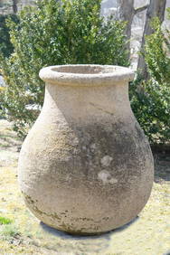
6 days LeftNew England Auctions - Fred GiampietroVery Large Round French Carved Stone Pot/Planter$300(3 bids)
6 days LeftNew England Auctions - Fred GiampietroVery Large Round French Carved Stone Pot$275(2 bids)


![Royaume de France, divisé en Gouvernements. Provinces.: TITLE/CONTENT OF MAP: 'Royaume de France, divisé en Gouvernements [The Kingdom of France, divided into Provinces]' DATE PRINTED: 1789 IMAGE SIZE: Approx 24.5 x 36.0cm, 9.75 x 14.25 inches (Large); Pl](https://p1.liveauctioneers.com/5584/156033/78749996_1_x.jpg?height=310&quality=70&version=1575421548)


![Europe en 1100. Europe in 1100. MALTE-BRUN c1871 old antique map plan chart: TITLE/CONTENT OF MAP: 'Europe en 1100 indiquant la date de la fondation des différens etats [Europe in 1100 indicating the dates of the foundation of the different states]' DATE PRINTED: c1871 IM](https://p1.liveauctioneers.com/5584/267896/140242912_1_x.jpg?height=310&quality=70&version=1668549165)