Sold20221898 Topographical Colored Maps of Worcester County,LJ Richards & Co. Pub. Plate #2 Worcester is missing Cover is detached 22" x 17" Please see photos and come to the 2 day preview for condition.See Sold Price
Sold20211908 Scroll Map of Wentworth CountyCanadian. 1908. Scale: 1 inch equals 1 mile. Marked, "Published by the Howell Litho Coy Ltd. Hamilton, Ont.". Surrounded by period advertisements from local companies. 45 x 39". CODE:CANSee Sold Price
Sold2017Early Map1858 Dutchess County map. John Gillette Publisher....Philadelphia. As found.See Sold Price
Sold2018S. H. Mathews Map of Geauga and Lake CountiesS. H. Mathews Map of Geauga and Lake Counties, 1857.See Sold Price
Sold2022History of Worcester County, Massachusetts 1889 Vol. 1 & 2With Biological Sketches of Many of it's Pioneers and Prominent Men, by D. Hamilton Hurd Volume 1 & 2. 1889. Some staining, loose and missing pages. Map has tape repair. Please see photos and come toSee Sold Price
Sold20181833 Census Map of the Counties of Leicester,Reserve Reduced! Title/Content of Map:1833 Census Map of the Counties of Leicester, Northampton, Ruthland, Warwick and Worcester -- Counties of Leicester, Northampton, Ruthland, Warwick and WorcesterSee Sold Price
Sold2019Weller, Edward C1860 Lot of 7 UK County MapsIncl Northants, Worcester, Lancashire, Monmouth, Hereford, and Somerset. Lithograph Maps Published C1860, London for "The Dispatch Atlas" and/or "The Weekly Dispatch" by Edward Weller and others. InclSee Sold Price
Sold20191886 California from Mitchell atlasFine antique lithograph map with original hand color. “County Map of the State of California” by William Bradley and found in the 1887 Mitchell New General Atlas. Detailed, scarce and interestingSee Sold Price
Sold2023Antique Hyde and Co Brooklyn NY Wall Map Scroll 1895Hyde and Co Brooklyn NY Map 1895. Map of the city of Brooklyn, Kings County, with wooden roll bars on top and bottom. Published by Hyde and Co of Brooklyn NY.Dimensions are 37 in h x 27 in w. ConditioSee Sold Price
Sold20221903, 1906, 1921, 1924, 1928 Worcester DirectoriesContains Directory of Citizens, Businesses, City and County Registers with map, streets and business directories. Wear and some tearing. Please see photos and come to the 2 day preview for condition.See Sold Price
Sold2023Early Wall Map of Dutchess Putnam New York, David Burr 1839Early Wall Map of Dutchessand Putnam County New York, David Burr 1839. Antique map in scroll format with thick dark painted wood supports features cities of the period including Poughkeepsie, RhinebecSee Sold Price
Sold20181857 MONK'S NEW AMERICAN MAP OF NORTH AMERICA, UNITED1857 MONK'S NEW AMERICAN MAP OF NORTH AMERICA, UNITED STATES AND TERRITORIES AND MORE AS PICTURED. MEASURES 60" X 66". HAS SOME TEARS, STAINS, AND CRINKLING USUALLY FOUND WITH THESE ROLL DOWN EARLY MASee Sold Price
Sold2018Group of New York State Historical MapsGroup of New York State Historical Maps. Map of Orleans County, NY, 1852 (40" x 47"); Map of Village of Albion, NY, 1857 (40" x 47"); Map of the State of New York, 1833 (21" x 25 1/2").. The RochesterSee Sold Price
Sold20191857 Colton Map of Australia -- AustraliaReserve Reduced! Title/Content of Map: 1857 Colton Map of Australia -- Australia Date: 1855, New York Cartographer: J Colton Size: 12.5 X 14.6 in. This is a very nice map of Australia. The counties arSee Sold Price
Sold2022Two New Hampshire Wall Maps.Belknap County, Smith and Peavy, 1860, 53 x 56 inches. Rockingham County, Smith and Coffin, 1857, 56 x 59 inches. Both in poor condition.See Sold Price
Sold2019Toms & Badeslade 1742 Hand Coloured Map of Worcester"A Map of Worcestershire" Hand Coloured Copper Engraved Map Published 1742, London for "Chorographia Britanniae, or a set of maps of all the counties in England and Wales" by Thomas Badeslade & WilliaSee Sold Price
Sold2024ANTIQUE TRAVEL GUIDE MAP OF JAPANAntique (1843 - 1865) Woodblock Travel Guide Map of Japan. The vibrantly colored map was created in three stages: Tempo (1843), Ansei (1857), Keio (1865). The map is set on a scroll and accompanied bySee Sold Price
Sold202018TH C DR WALL WORCESTER BLUE SCALE TEAPOTA George III teapot of blue scale ground with hand painted Rococo cartouches of colourful Chelsea birds within gilt scroll frames. Similar framed depictions of butterflies are found throughout the bodSee Sold Price
Sold2023Map of St. Paul / Map of the City Of Fargo, Cass County, North DakotaTitle: Map of St. Paul / Map of the City Of Fargo, Cass County, North Dakota Cartographer: CRAM, GEORGE F. Publisher: GEO. F. CRAM Date: ©1904 Description: Seldom found city plan of Fargo. HeightSee Sold Price
Sold2016Excellent period Hepplewhite ca 1790-1810 rare carvedExcellent period Hepplewhite ca 1790-1810 rare carved tiger maple 4 dr chest from Worcester County MA featuring wonderful deep scalloped apron & high flaring French feet in old surfaceSee Sold Price
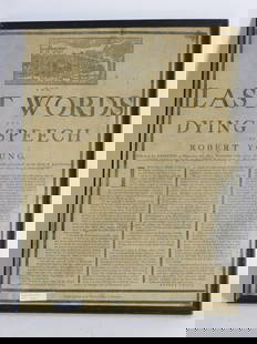
Sold2024The Last Words and Dying Speech of Robert Youngprinted broadside by the Printing Office Worcester. Young was executed on March 11, 1779 for the rape of the 11 year old child of Jane Green in Brookfield, Worcester County on September 3. At the topSee Sold Price
Sold20241826 Gaskill-Mowry Quaker Marriage CertificateQuaker Marriage Certificate, May 3rd, 1826. Label on back: "Unxbridge, Massachusetts Friends Meeting May 3, 1826 - Joseph Gaskill and Isabella Mowry - Both of Uxbridge, Worcester County, MassachusettsSee Sold Price
Featured18 hrs LeftJasper521878 Mitchell Map of Virginia and West Virginia [verso] New Jersey, Maryland and Delaware -- County$45
Jun 08Early American History Auctions1720 Colonial Northumberland County Virginia Manuscript Deed and Map Plot$400
Jun 23Schilb Antiquarian Rare Books1890 Livingstone 1ed In Darkest Africa Henry Stanley Emin Pasha Expedition MAP$16(3 bids)
1 day LeftThomaston Place Auction Galleries1857 KANSAS & NEBRASKA HANDBOOK BOUND WITH LIFE OF GEN JOSEPH WARREN$100


![1878 Mitchell Map of Virginia and West Virginia [verso] New Jersey, Maryland and Delaware -- County (1 of 2)](https://p1.liveauctioneers.com/5584/329422/177662152_1_x.jpg?height=282&quality=70&version=1715717898)


