Sold2024Europe exhibiting its principal states &c. First French Empire. FADEN 1791 mapTITLE/CONTENT OF MAP: 'Europe exhibiting its principal states &c' DATE PRINTED: 1791 IMAGE SIZE: Approx 54.5 x 69.5cm, 21.5 x 27.25 inches (Large); Please note that this is a folding map. TYPE: LargeSee Sold Price
Sold20231755 Fry Jefferson Map, French Edition First State"Carte de la Virginie et du Maryland dressee sur la grande carte angloise de Mrs. Josue Fry et Pierre Jefferson", hand colored first state of Robert de Vaugondy's French edition of the Fry Jefferson mSee Sold Price
Sold2020Exceptional French Empire Gilt-Bronze ClockExceptional French Empire Gilt-Bronze Clock first quarter 19th century, the clock supported by a pair of Eros figures, with a crest depicting a rose blooming with an emerging angel, with a rectangularSee Sold Price
Sold2015Cary's New Universal Atlas,Containing Distinct Maps of All the Principal States and Kingdoms, etc., London: Printed for J. Cary, Engraver, 1811, with 56 double-page engraved hand-colored maps on 60 numbered sheets (complete), rSee Sold Price
Sold2022MITCHELL'S UNIVERSAL ATLASNew Universal Atlas Containing Maps of the various Empires, Kingdoms, States, and Republics of the World, S. Augustus Mitchell, Philadelphia, 1847; Condition: boards detached; 17 1/4 x 14 inchesSee Sold Price
Sold2021French Empire Secretaire Abattant 41"w x16"d x57"hFrench Empire Secretaire Abattant 41"w x16"d x57"hSee Sold Price
Sold2022French Empire Gilt Bronze & Marble Figural Mantel ClockFrench Empire Gilt Bronze & Marble Figural Mantel Clockfirst half 19th centurythe clock surmounted by a seated figure playing the harp and Cupid, 8-day brass time and strike movement with silk threadSee Sold Price
Sold2020French Empire Parcel-Gilt Trumeau MirrorFrench Empire Painted and Parcel-Gilt Trumeau Mirror first quarter 19th century, the recessed upper tablet with a blue ground and decorated with swags of giltwood bowknots, flanked by satyrs in featheSee Sold Price
Sold2022Pair of French Empire Bronze CandelabraPair of French Empire Bronze and Patinated Bronze Candelabra first quarter 19th century, decorated with patinated bronze winged figures perching on spherules, raised on engine-turned column-form basesSee Sold Price
Sold2016A Fine French Empire Gilt Bronze Figural MantelA Fine French Empire Gilt Bronze Figural Mantel Clock, first half 19th centuryMarks tSee Sold Price
Sold2022MAPS IN BOOK, Atlases, CareyCarey's Famous 1814 General Atlas. Atlases. Mathew Carey, Carey's General Atlas, Improved and Enlarged: Being a Collection of Maps of the World and Quarters, Their Principal Empires, Kingdoms, &c., 18See Sold Price
Sold2016Li Pei Qing - Chinese Cloisonne Enamel Copper GoldenA statue made of copper with Chinese cloisonne enamel; depicting golden fish; comes with a wooden stand; made by Li Pei Qing, China Cloisonne The first recognized in the United States and Europe, acroSee Sold Price
Sold2023A French silver gilt tea & coffee set, OdiotA French Empire style silver gilt four piece tea and coffee service with trayMaison Odiot, Parisfirst half 20th centuryComprising a teapot, a coffee pot, a cream jug, a sugar bowl and an oval tray, wiSee Sold Price
Sold2022Pr Empire Gilt Bronze Blackamoor Candelabras, 19th CProperty from the Estate of Murray C. Perlman, Savannah, GA Description: Pair of French Empire Gilt Bronze and Bronze Blackamoor-Form 2-Light Candelabras, First Quarter 19th Century, the pair compSee Sold Price
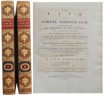
Sold2023Boswell, The Life of Samuel Johnson 1st Ed 1791This is a two-volume set of The Life of Samuel Johnson, written by James Boswell and published in 1791, and it is a first edition in the first state. The title page reads The Life Of Samuel Johnson, LSee Sold Price
Sold2020Laurie & Whittle Map of AmericaLAURIE & WHITTLE (Late 18th Century)The United States of America...Engraved map with original hand color in full.London: Laurie & Whittle, 1794.20 1/4" x 22 1/2" sheet.The first British map to show thSee Sold Price
Sold2023RARE BUCHOLTZ-LUDWIG ANTEBELLUM POCKET MAP OF VIRGINIARARE BUCHOLTZ-LUDWIG ANTEBELLUM POCKET MAP OF VIRGINIA, hand-colored lithograph, Map of the State of Virginia Containing the Counties, Principal Towns, Railroads, Rivers, Canals & All Other Internal ISee Sold Price
Sold2021PR. 19TH C. VICTORY EMPIRE ORMOLU CANDELABRAManner of Pierre Philippe Thomire (French, 1751–1843), first quarter 19th century. Pair of figural Empire bronze dore ormolu five-light candelabra, each depicting winged victory, holding aloft a floSee Sold Price
Sold2022Rob Zell Breier - 1989 - San Francisco Oz by the Bay - Poster / Map of United States -Vintage map of San Francisco that presents the city as ‘Oz by the Bay’ Its four corners feature vignettes of four principal characters of the novel including the Tin Man, the Lion, the ScSee Sold Price
Sold2024Abraham Ortelius Map Middle East "Turcici Imperii Descriptio"showing the Turkish Empire, Saudi Arabia, south east Europe and Egyp tSee Sold Price
Sold2024Lot of 3 small maps from Scott's Gazeteer "Vermont, New Hampshire and N.W. Territories"Scott's Gazetteer, published in 1795 by Joseph Scott, is considered the first gazetteer of the United States. It's a comprehensive reference book offering detailed descriptions of the various states iSee Sold Price
Sold20211825 Plan of Yorktown in Virginia & Adj Country1825 Map, Plan of Yorktown in Virginia and Adjacent Country, Exhibiting the operations of the American French & English armies, during the Siege of that place in Oct. 1781. Sheet is irregularly trimmeSee Sold Price
Sold2022Mitchell's large Mexican-American War map, 1847Heading: Author: Mitchell, Samuel Augustus Title: Map of Mexico, Including Yucatan & Upper California, Exhibiting the Chief Cities and Towns, the Principal Travelling Routes &c. Place Published: PhilSee Sold Price
2021GREAT NORTHERN’S 2 GREAT TRAINS SYSTEM MAP.Huge dramatic reverse glass advertising Great Northern's two great trains, Empire Builder and Western Star. In script just below Great Northern logo it states "Steamliners twice a day, each way, betweSee Sold Price
3 days LeftJasper521869 Mitchell Map of Much of Western Europe -- XXXII Prussia the German States Holland & Belgium$30
95 Lots AwayHermann Historica GmbHA French officer's sabre, First Empire, early 19th centurySee Sold Price
5 days LeftPotter & Potter AuctionsArmour’s Food Source Map / The Greatness of the United Stat...$200
May 19Ukiyoe Gallery Japanese Woodblock PrintsHiroshi Yoshida - Evening in Nara 1st Ed Woodblock Print$350(2 bids)
19 hrs LeftSchilb Antiquarian Rare Books1844 Siege of Gibraltar American Revolution SPAIN France Drinkwater MAP History$3(3 bids)
5 days LeftZikorn Arts & History ObjectsJames Crawford Thom: The Neighbors, 1862, Oil on Canvas$2,500(2 bids)
7 days LeftKennedys Auction Service LLCJean-Jacques Rousseau Memento Mori Silk Embroidery$120(4 bids)
5 days LeftPotter & Potter AuctionsRCA Victor Radio, Amusement and Educational Map of the Worl...$100
May 19Ukiyoe Gallery Japanese Woodblock PrintsTadashige Ono: Pisa In Rain 1st Ed 1961 Woodblock$100(1 bid)
May 30Forum AuctionsTolkien (J.R.R.) The Hobbit; or There and Back Again, first American edition, first state, Boston£800(1 bid)
Jun 02Schilb Antiquarian Rare Books1897 History of British Empire England Scotland Canada James II MAPS India 6v$1(1 bid)


![[FURNITURE]. Empire Secretaire a Abattant. [France, ca. 181... (1 of 8)](https://p1.liveauctioneers.com/928/328184/176813336_1_x.jpg?height=282&quality=70&version=1714673785)


