Sold20191862 Johnson Map of Washington DC -- Johnson'sTitle: 1862 Johnson Map of Washington DC -- Johnson's Georgetown and the City of Washington the Capital of the United States of America Date: 1862, New York Cartographer: Johnson and Browning Size: 12See Sold Price
Sold20241863 Johnson Map of Washington DC -- Johnson's Georgetown and the City of Washington the Capital ofTitle: 1863 Johnson Map of Washington DC -- Johnson's Georgetown and the City of Washington the Capital of the United States of America Cartographer: Johnson & Ward Year / Place: 1863, New York Map DiSee Sold Price
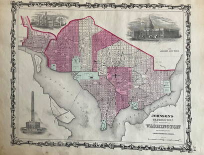
Sold20221868 Johnson Map of Washington DC -- Johnson's Washington and GeorgetownTitle: 1868 Johnson Map of Washington DC -- Johnson's Washington and Georgetown Cartographer: A Johnson Year / Place: 1868, New York Map Dimension (in.): 12.8 X 16.7 in. This is a superb map of WashinSee Sold Price
Sold2022Washington D.C. 1862 by Johnson and WardTitle: Washington D.C. 1862 by Johnson and Ward Date/Period: 1862 Materials: Steel plate engraved Size: 19" x 14" 1862 from 'Johnson's New Illustrated Family Atlas' By Johnson and Ward. Published in NSee Sold Price
Sold2017Johnson: Antique Map of Washington D.C., 1868Title/Content of Map: Washington D.C. by Johnson Date Printed: 1868 Cartographer: A.J. Johnson Material/Medium: Paper Size: 18" x13" Hand colored engraved Map. From Johnson's New Illustrated Family AtSee Sold Price
Sold2017Johnson: Map of Washington & Oregon, 1862Map: Johnson’s Washington and Oregon Maker: Johnson & Ward Date: 1862 Size: 12.5 x 15.5 inches Condition: Beautiful map with great color, good print and wide margins. Couple of tiny margin spots. HaSee Sold Price
Sold2016Map of Washington DC & Georgetown, 1868Original engraving from Johnson's Atlas of the World, 1868. Map details city of Georgetown, mall & Capitol. Dimensions: 14 1/2" x 18". This item ships from Ocean View, DE.See Sold Price
Sold2022Smith, Story of Washington, D.C. 1st Edition 1967 illustrated"Washington, D.C. The Story of Our Nation's Capital" by Howard K. Smith, dedicated to the First Lady Mrs. Lyndon B. Johnson, illustrated with Photographs and Maps, published by Random House, 1967, FirSee Sold Price
Sold2016Adiagram Chart of Washington DC, 1868Original engraving from Johnson's Atlas of the World, 1868. Map details the difference of time between the places shown & Washington, DC. Dimensions: 14 1/2" x 18". This item ships from Ocean View, DESee Sold Price
Sold2022FRAMED MAP OF DELAWARE & MARYLAND (& DC)"Johnson's Delaware and Maryland" by A. J. Johnson, 1860, published in NYC. Hand colored engraving. Includes vignette map of "Washington City", giving an 1850 population of 29,815 Whites, 8,073 Free CSee Sold Price
Sold20221862 Johnson Map of Nebraska, Dakota, Colorado andTitle: 1862 Johnson Map of Nebraska, Dakota, Colorado and Kansas -- Johnson's Nebraska, Dakota, Colorado, & Kansas. Cartographer: Johnson and Ward Date/Place: 1862, New York Dimensions: 12.4 X 15.4 DeSee Sold Price
Sold20201862 Johnson Map of Florida -- Johnson's FloridaTitle: 1862 Johnson Map of Florida -- Johnson's Florida Cartographer: Johnson & Browning Year/Place: 1862, New York City Size: 12 x 15.3 in. Description: This is an excellent Johnson map of Florida, sSee Sold Price
Sold20211862 Johnson Map of Civil War Virginia East of RichmondTitle: 1862 Johnson Map of Civil War Virginia East of Richmond -- Johnson's Map of the Vicinity of Richmond, and Peninsular Campaign in Virginia Cartographer: Johnson & Ward Year / Place: 1862, New YoSee Sold Price
Sold20201862 Johnson Map of North and South Carolina --Title/Content of Map: 1862 Johnson Map of North and South Carolina -- Johnson's North and South Carolina Date: 1864, New York Cartographer: Johnson & Browning Size: 17.3 x 24 in. This is an excellent,See Sold Price
Sold20231862 Johnson Map of Civil War Virginia East of Richmond -- Johnson's Map of the Vicinity ofTitle: 1862 Johnson Map of Civil War Virginia East of Richmond -- Johnson's Map of the Vicinity of Richmond, and Peninsular Campaign in Virginia Cartographer: Johnson & Ward Year / Place: 1862, New YoSee Sold Price
Sold20191862 Johnson Map of Mexico -- Johnson's MexicoTitle: 1862 Johnson Map of Mexico -- Johnson's Mexico Cartographer: Johnson & Browning Date: 1862, New York Size: 12.5 x 15.5 in. Additional Information: Very nice map of Mexico, color-coding the statSee Sold Price
Sold20191862 Johnson Map of India and Southeast Asia --Title: 1862 Johnson Map of India and Southeast Asia -- Johnson's Hindostan or British India Cartographer: Johnson & Browning Date: 1862, New York Size: 12.3 X 15.3 in. Additional Information: This isSee Sold Price
Sold20221862 Johnson Map of New Hampshire and Vermont --Title: 1862 Johnson Map of New Hampshire and Vermont -- Johnson's New Hampshire and Vermont Cartographer: Johnson & Browning Year/Place: 1862, New York Dimensions: 24 x 17 in. Description: This is a fSee Sold Price
Sold20191862 Johnson Map of Central America -- Johnson'sTitle: 1862 Johnson Map of Central America -- Johnson's Central America Cartographer: Johnson & Browning Date: 1862, New York Size: 12.3 X 15.3 in. Additional Information: This is an excellent map ofSee Sold Price
Sold2021Vic. of Richmond Civil War map, Johnson 1862A scarce and important map produced during the Civil War. The map shows the Union advance during the Peninsular Campaign including great detail ranging from nautical depth soundings to individual builSee Sold Price
Sold20221863 Johnson Map of Washington and Georgetown -- Johnson's Georgetown and the City of Washington theTitle: 1863 Johnson Map of Washington and Georgetown -- Johnson's Georgetown and the City of Washington the Capital of the United States of America Cartographer: Johnson and Ward Date/Place: 1863, NewSee Sold Price
Sold20231865 Johnson Map of Oregon and Washington -- Johnson's Oregon and WashingtonTitle: 1865 Johnson Map of Oregon and Washington -- Johnson's Oregon and Washington Cartographer: A Johnson Year / Place: 1865, New York Map Dimension (in.): 16.8 X 12 in. This is a superb map of WashSee Sold Price
Sold20231866 Johnson Map of Washington, Oregon Minnesota -- Johnson's Oregon and Washington [on sheet with]Title: 1866 Johnson Map of Washington, Oregon Minnesota -- Johnson's Oregon and Washington [on sheet with] Johnson's Minnesota Cartographer: Johnson & Ward Year / Place: 1866, New York Map Dimension (See Sold Price
Sold2017Johnson’s Map of the Vicinity of Richmond, 186217.75 x 26.5 inches. This is a rare and important 1862 A. J. Johnson map of the vicinity of Richmond, Virginia, during the American Civil War. The map shows the Union advance during the Peninsular CamSee Sold Price
May 15University ArchivesHarry S. Truman, Lyndon B. Johnson, and Richard M. Nixon Inaugural Group$140
672 Lots AwayThe Rug LifeGUSTAV KLIMT (1862-1918) COLLOTYPE TITLED THE KISS, 17.5IN x 17.5IN (44.5cm x 44.5cm)$400
5 days LeftJasper521894 Johnson Map of New England States -- Johnson's Section Map and Index of the New England States$80
May 15University ArchivesLBJ Pen Used to Sign 1965 Act to Establish National Tech Institute for the Deaf$300


![1866 Johnson Map of Washington, Oregon Minnesota -- Johnson's Oregon and Washington [on sheet with]: Title: 1866 Johnson Map of Washington, Oregon Minnesota -- Johnson's Oregon and Washington [on sheet with] Johnson's Minnesota Cartographer: Johnson & Ward Year / Place: 1866, New York Map Dimension (](https://p1.liveauctioneers.com/5584/300803/160206896_1_x.jpg?height=310&quality=70&version=1693946338)


