Sold20231910 National Map Company Wall Map State Of New York1910 roll down wall map printed by the National Map Company showing the counties, towns, roads, steamships routes etc within the State Of New York. The map which measures approximately 44" by 64" togeSee Sold Price
Sold20231902 National Publishing Company Wall Map1902 roll down wall map printed by the National Publishing Company New Railroad, Post office, Township, and County Map of New York which measures approximately 48" by 41". Condition - fine.See Sold Price
Sold2023`1903 Scarborough Railroad Map of New York1903 "Scarborough's New Railroad Map of the State of New York, printed by the National Publishing Company Boston, Mass. in overall good condition 41.5" x 52See Sold Price
Sold2016Official Maps of New YorkNumerous color maps of all areas of New York State. 128 pages. Publisher National Survey Company Dated: Circa 1925 Demensions: 8vo Provenance: Property of a New York City Gentleman ConditionSee Sold Price
Sold20182V Elon Howard Eaton NEW YORK STATE MUSEUM MEMOIR 122V Elon Howard Eaton NEW YORK STATE MUSEUM MEMOIR 12 BIRDS OF NEW YORK 1910-1914 Complete Set Illustrated Color Plates Louis Agassiz Fuertes Maps Charts Tables Water Game Land Ornithology PhotographsSee Sold Price
Sold2018Antique Wall Map NEW YORK POSTAL ROUTES 1898 MailDetails: This large hanging wall map of postal routes in the state of New York was created by topographer A. von Haake, and printed by "Julius Bien & Co., Photo. Lith." Dated March, 1, 1898, this mapSee Sold Price
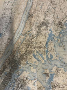
Sold2022(NEW YORK.) John Homer French. The State of New York from New and Original Surveys.(NEW YORK.) John Homer French. The State of New York from New and Original Surveys. Large hand-colored engraved wall map of New York with many inset views and detail maps. 4 sheets joined, 68x73 incheSee Sold Price
Sold2023US WALL MAPS AND AERIAL VIEW OF NEW YORK CITYA lot of three antique and vintage wall maps of New York. The lot includes a 1914 map of New York bay and harbor, a D. Lambert Railing Co. color map of New York State, and an aerial view of Hudson RivSee Sold Price
Sold2020Railroad & Township Map of New YorkHeading: Author: Colton, J.H. Title: Colton's Railroad & Township Map of the State Of New York. With Parts of the Adjoining States & Canada Place Published: New York Publisher:Colton & Company DSee Sold Price
Sold20231892 Adams and Bowles New Road Map of the State of New YorkThis is a large, wall-hanging 1892 Adams and Bowles New Road Map of the State of New York. It also highlights railroad lines in the state. Paper on linen, with both top and bottom dowels present. FineSee Sold Price
Sold20241892 Adams and Bowles New Road Map of the State of New YorkThis is a large, wall-hanging 1892 Adams and Bowles New Road Map of the State of New York. It also highlights railroad lines in the state. Paper on linen, with both top and bottom dowels present. FineSee Sold Price
Sold2023MAP: United States - East Coast/ New York. New Jersey/ Hudson RiverDescription: United States - East Coast/ New York. New Jersey/ Hudson River/ New York to Wappinger Creek. PUBLISHED at Washington DC. US Department of Commerce, NATIONAL OCEANIC AND ATMOSPHERIC ADMINISee Sold Price
Sold2023Group lot of NEW YORK State Topographical MapsGroup lot of NEW YORK State Topographical Maps, maps measure 17 x 21 inches, wear consistent with age and use. not framed. Art, wall art, artwork, home decor, maps, topographic, topography, New York SSee Sold Price
Sold2022Group lot of NEW YORK State Topographical MapsGroup lot of NEW YORK State Topographical Maps, maps measure 17 x 21 inches, wear consistent with age and use. not framed. Art, wall art, artwork, home decor, maps, topographic, topography, New York SSee Sold Price
Sold2023Map: United States– East Coast / Connecticut– New York/ Long Island Western PartDescription: United States– East Coast / Connecticut– New York/ Long Island Western Part. Published at Washington D.C. US Department of Commerce, National Oceanic Service. Measurement apSee Sold Price
Sold20203 Volumes on New York HistoryIncludes: Barber & Howe. Historical Collections of the State of New York. 1842. Large 8vo, worn leather, staining. Folding map of NY laid in at front. + Historical Souvenir of the Hudson-Fulton CelebrSee Sold Price
Sold20192V ANNUAL REPORTS OF THE FOREST FISH AND GAME2V ANNUAL REPORTS OF THE FOREST FISH AND GAME COMMISSIONER OF THE STATE OF NEW YORK 1897 1907-1909 Illustrated Chromolithograph Fish Animals Map Adirondack Denton Gillette Maple Syrup This auction lotSee Sold Price
Sold20211871 Map of the United StatesTitle: 1871 Map of the United States Medium: Ink on Paper Dimensions: 17.5"X11.5" Description: Map of the US dated 1871. This map was published by A.S. Barnes and Company in New York and Chicago. PartSee Sold Price
Sold2018Hand Colored Antique Map Of New Amsterdam (New York)Map of the Original Grants of Village Lots from the Dutch West India Company to the inhabitant of New-Amsterdam, (now New-York) living below the present line of Wall Street. 19 1/2 x 17 in. (Framed),See Sold Price
Sold2024American Express/New York Central Railroad Map of the United States-1934This is a railroad map of the United States, as produced by the American Express Company, for distribution by the New York Central Railroad in 1934. New York Central lines are featured on this map, thSee Sold Price
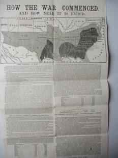
Sold20221864 - How The War Commenced BroadsideHow The War Commenced And How Near It Is Ended. Broadside Published by the National Union Executive Committee Astor House New York - Has Map of The Southern States and Who Commenced The War With A TimSee Sold Price
Sold2019LARGE WALL MAP ULSTER COUNTY NEW YORKLARGE WALL MAP ULSTER COUNTY NEW YORK-OLIVER TILLSON, C. 1853 44" X 54"See Sold Price
Sold2016Wall Map Rockland County New York, 1854WALL MAP ROCKLAND COUNTY NEW YORK, 1854 Surveyed and Published by R.F.O' Connor, New York Dimension: 46.6" x 34" Condition: Good , no stains or repairs. General handling wear. Provenance: Private EstaSee Sold Price
Sold20211911 Sanborn Insurance Map of Hudson New York Folio1911 Sanborn Insurance Map of Hudson, New York. 23 maps are included. This books of maps was made by the Sanborn Map Company of New York City. Map includes detailed descriptions of each business layouSee Sold Price
May 16Potter & Potter AuctionsBOURNE, Emma (1906 – 1986). America – A Nation of One Peopl...$125(1 bid)
6 days LeftJasper521910 TRANS-HIMALAYA DISCOVERIES & ADVENTURES in TIBET antique ILLUSTRATED 3 vols$480
22 hrs LeftRapid Estate Liquidators and Auction GalleryLeather Bound This Is My Country By Felix Jones$30
BonhamsWalker Evans (1903-1975); Seven Photographs including: Hudson Street Boarding House Interior, Ne...$750
May 16Zikorn Arts & History ObjectsJeane Dixon (Signed): Gift of Prophecy Phenomenal Jeane Dixon 1965$50
22 hrs LeftRapid Estate Liquidators and Auction GalleryTwo Classic Antique Hardcover Mark Twain Horatio Alger Jr$35


![[WWI] P.T. Sherman's WWI Service Record & Books (1 of 8)](https://p1.liveauctioneers.com/7226/322253/173251586_1_x.jpg?height=282&quality=70&version=1710004847)


