Sold20221940s American Airlines US Route Map -- American Airlines System MapTitle: 1940s American Airlines US Route Map -- American Airlines System Map Cartographer: American Airlines (General Drafting Co.) Year / Place: 1940s c. Map Dimension (in.): 24 X 32 in. Ths is an attSee Sold Price
Sold20231950s American Airlines Route Map -- American Airlines Route MapTitle: 1950s American Airlines Route Map -- American Airlines Route Map Cartographer: American Airlines Year / Place: 1950s Map Dimension (in.): 12.5 X 19.2 in. joined This nice, large pictorial routeSee Sold Price
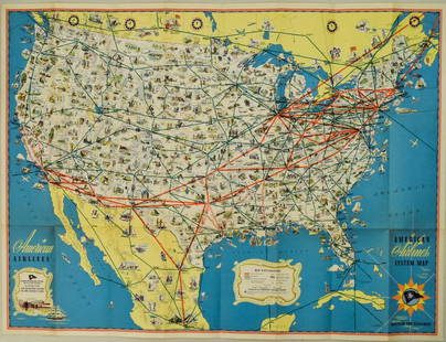
Sold2024American Airlines System Map. Route of the Flagships. Pictorial 24"x32" c1945CAPTION PRINTED BELOW PICTURE: 'American Airlines System Map - Route of the Flagships' DATE PRINTED: c1945 IMAGE SIZE: Approx 60.5 x 80.5cm, 23.75 x 31.75 inches (Large); Please note that this is a foSee Sold Price
Sold2018American Airlines System Map Route Of The Flagships 194American Airlines System Map Route Of The Flagships 1946See Sold Price
Sold2019Pan American Airways System. World Map 1956.Pan American Airways System. World Map 1956. Art by John Brown, cartography by John Philip. Offset poster showing the airline’s routes across the world. 34 x 60”. Inpainting to lower image, minorSee Sold Price
Sold2018Pan American Airways System. World Map 1968Pan American Airways System. World Map 1968. Art by John Brown, cartography by John Philip. Offset poster showing the airline's routes across the world. Linen backed. 18 x 32". A.See Sold Price
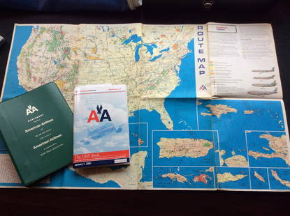
Sold2023Vintage American Airlines Route Map, American Airline Trip Book and BinderVintage American Airlines Route Map, American Airline Trip Book and BinderSee Sold Price
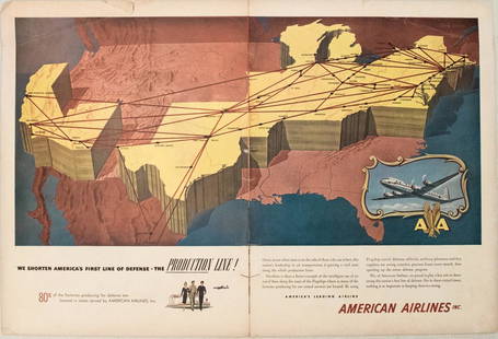
Sold20191949 American Airlines Route Map AdTitle/Content of Map: 1949 American Airlines Route Map Ad Date: 1949Cartographer: American Airlines Size: 13.6 X 21 in. when joined This is an attractive ad highlightingAmerican Airlines routes - servSee Sold Price
Sold2023PAN AMERICAN AIRLINES ROUTE MAP. "Fastest way between… USA & Latin America" 1935Title: PAN AMERICAN AIRLINES ROUTE MAP. "Fastest way between… USA & Latin America" 1935 Description: Consult this map for fastest way between all points in the United States and Latin America' bSee Sold Price
Sold2018American Airlines Route Map World's Fair Line 1939American Airlines Route Map World's Fair Line 1939See Sold Price
Sold2018American Airlines System Map 1952American Airlines System Map 1952, 33 1/2" x24"See Sold Price
Sold2018American Airlines System Maps Circa 1960's/70's?American Airlines System Maps Circa 1960's/70'sSee Sold Price
Sold20181957 Route Map of Pan American Airline to Mexico,Title/Content of Map: 1957 Route Map of Pan American Airline to Mexico, Central America and Part of Caribbean -- Pan American Flight Map [to] Mexico & Central America Date: 1957 Cartographer: PanAm SiSee Sold Price
Sold20171950 Map of PanAm Airline Caribbean Routes1950 Map of PanAm Airline Caribbean Routes -- Pan American Flight Map New York and Caribbean. PanAm, 1950 ca., A nice folding map of Pan American Airline routes to Caribbean from New York City & MiamiSee Sold Price
Sold20221947 New England Airport Map & Circa 60's American AirlinesSystem Map. New England Map has some tearing. Please see photos and come to the 2 day preview for condition.See Sold Price
Sold2018Pan American Airways Circa 1950's System Route MapPan American Airways Circa 1950's System Route MapSee Sold Price
Sold2022Pan American Airlines Clipper Club Pilot's 1940's Map.Showing routes flown, framed, 19 x 33 inches.See Sold Price
Sold20231950s Hawaiian Airline Route Map of Hawaii -- Hawaiian Airline Map of the State of HawaiiTitle: 1950s Hawaiian Airline Route Map of Hawaii -- Hawaiian Airline Map of the State of Hawaii Cartographer: Hawaiian Airline Year / Place: mid 1950s Map Dimension (in.): 9.2 x 24 in This is a verySee Sold Price
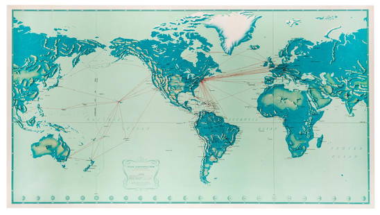
Sold2018Two Large Maps of the WorldTwo Large Maps of the World, American Air Lines & Menier Chocolate. American Airlines Air World Map, showing the distances to various cities and locations from the geographical center of the United StSee Sold Price
Sold2019Mixed LotSebastian advertising plaque, American Airlines Freight System 1974 belt buckle, Gillette razor in case, Beatles postcard, New Jersey Turnpike 1950s ashtray, Evening in Paris compact, Vanderbilt HotelSee Sold Price
Sold2018North Atlantic Airlines Route Map Information Booklet CNorth Atlantic Airlines Route Map Information Booklet Circa 1950sSee Sold Price
Sold20231950s Pan Am World Route Maps -- Route Maps Pan AmericanTitle: 1950s Pan Am World Route Maps -- Route Maps Pan American Cartographer: PanAm Year / Place: late 1950s c. Map Dimension (in.): 9 x 12 in. single page This is an outstanding 6 double page fold-ouSee Sold Price
Jul 12American Antique AuctionsMid Century Scandanavian Furniture Catalogs Treasure Trove Originals!$70(2 bids)
3 days LeftSwann Auction Galleries(PANAMA.) George U. Mayo. Letter from a survivor of the ill-fated Darien Exploring Expedition,$1,500
BonhamsPEARY'S COPY OF AN EARLY NORTH AMERICAN MAP. PEARY, ROBERT E. 1856-1920.] DOBBS, ARTHUR. 1689-17...$320(4 bids)
2 days LeftActivity AuctionsOriginal Vintage Poster AMERICAN AIRLINES ARIZONA Airline Travel Tourism LINEN$1,300
3 days LeftSwann Auction Galleries(AMERICAN REVOLUTION--1776.) Map titled "Boston and the Adjacent Country, with the Stations of the$750
3 days LeftLeland LittleEmanuel Bowen (English, 1697-1767), Map of the American Southeast$100(2 bids)
2 days LeftWestmore Galleries and AuctionsNorth America 1771 Colonial Map - 13 Colonies - 20x24$700(2 bids)
15 hrs LeftJasper521890 c. Clemens Wooden Puzzle Map of the US -- Clemens' Silent Teacher Dissected Map of the United$240
Freeman's | Hindman[MAPS - LOUISIANA - WAR OF 1812]. Maps of Louisiana, incl. Battle of New Orleans battle site map.$150(1 bid)


![1957 Route Map of Pan American Airline to Mexico,: Title/Content of Map: 1957 Route Map of Pan American Airline to Mexico, Central America and Part of Caribbean -- Pan American Flight Map [to] Mexico & Central America Date: 1957 Cartographer: PanAm Si](https://p1.liveauctioneers.com/5584/124256/63192867_1_x.jpg?height=310&quality=70&version=1530636078)


![PEARY'S COPY OF AN EARLY NORTH AMERICAN MAP. PEARY, ROBERT E. 1856-1920.] DOBBS, ARTHUR. 1689-17... (1 of 3)](https://p1.liveauctioneers.com/1043/333441/180036747_1_x.jpg?height=282&quality=70&version=1719180533)


![[MAPS - LOUISIANA - WAR OF 1812]. Maps of Louisiana, incl. Battle of New Orleans battle site map. (1 of 7)](https://p1.liveauctioneers.com/197/333931/180433328_1_x.jpg?height=282&quality=70&version=1719251353)

