Sold20231888 Railroad map of Montana locates battlefieldsDouble-page, vertical format map of Montana from an 1888 edition of George F. Cram's Unrivaled Family Atlas. An authentic, antique map that places battlefields, Indian reservations, t towns, rivers, lSee Sold Price
Sold2023Scarce early Cram RR map of Missouri“New Railroad and County Map of Missouri” from an exceedingly scarce 1882 edition of Cram’s Unrivaled Family Atlas of the World.” Collections of vintage maps of Missouri will nSee Sold Price
Sold2022Scarce early Cram RR map of North CarolinaDesirable and scarce railroad map of North Carolina from a very scarce and early Cram atlas. The 1882 edition of Cram’s Unrivaled Family Atlas of the World was the last Cram atlas to use hand cSee Sold Price
Sold20221st ed. near pristine McNally map of Texas & Ind. Terr., 1881Highly detailed and scarce large format railroad map, one of the best of the period. Rand, McNally & Co.’s Texas and Indian Territory, dated 1881 (first edition). This great map depicts railroadSee Sold Price
Sold2020IndianaTitle: Indiana Publication Date: 1899 Cartographer: CRAM, GEORGE F. Publisher: GEO. F. CRAM Size: 20Height - 16Width Detailed state map with all railroads color coded. From Cram's Standard American RaSee Sold Price
Sold20231st ed. near pristine McNally map of Calif. and Nevada, 1881Large format and highly detailed scarce map of California and Nevada. Rand, McNally & Co.’s California, published 1881 (dated first edition). Shows railroads, towns, rivers, topography, lakes, cSee Sold Price
Sold2022Scarce early Cram RR map of Southern states“New Railroad and County Map of Alabama, Georgia, South Carolina and North Carolina” from the extremely scarce 1882 edition of Cram’s Unrivaled Family Atlas of the World. This was tSee Sold Price
Sold2021Scarce 1882 RR map of New JerseyScarce map of New Jersey from the first mass-produced world atlas by George F. Cram. He published at least two versions of his 1883 Universal Family Atlas, an early edition and a later edition. The eaSee Sold Price
Sold2023Scarce 1846 true 1st ed. map of Florida showing Carey & Hart bordersHard-to-find map from Samuel Augustus Mitchell's true first edition of his New Universal Atlas shows the first two railroads in Florida, the Tallahassee Railroad and the Lake Wimico and St. Joseph CanSee Sold Price
Sold2022Mark TWAIN / Life on the Mississippi Signed 1st Edition 1883Mark TWAIN / Life on the Mississippi Signed 1st Edition 1883See Sold Price
Sold2022Stevenson, Robert Louis - Treasure Island, 1st edition - 1883Stevenson, Robert Louis (1850-1894) Treasure Island, 1st edition (1883) Description: Cassell & Company, limited, London, Paris & New York, 1883, 292 pages plus 8 pages selections. With the following eSee Sold Price
Sold20231st edition map of the South Pole, or Antarctica by ColtonExcellent 1855 first edition example of J. H. Colton’s map of the South Pole, Antarctica or Southern Polar Regions. The map gives an excellent overview of the state of Antarctic exploration andSee Sold Price
Sold20231st edition map of the Arctic, or North Pole by ColtonNice 1855 first edition example of J. H. Colton’s map of the North Pole or Arctic region. Extends from Lake Baikal, Hudson Bay, the British Isles and Kamchatka north to the Pole. The Polar regioSee Sold Price
Sold2024Crams Railroad Map of New York-1881This is a Crams Railroad Map of New York dated 1881, Has a great fold-out full color map of the state of New York showing all railroad lines. Has almost no tears or frays. Booklet has 36 pages of counSee Sold Price
Sold2020MinnesotaTitle: Minnesota Publication Date: 1856 Cartographer: Publisher: J.H. Colton & Co. Brief Descriptions: 1st edition. Map showing MN west to White Earth River. Details many towns, topo., Indian tribes &See Sold Price
Sold2018Cram's RailRoad & Township Map of Washington.Title: Cram's RailRoad & Township Map of Washington. Publication Date: 1881 Cartographer: GEO. F. CRAM Publisher: GEO. F. CRAM Size: 15.5X19 Published for Geo. F. Cram. Proprietor of the Western Map DSee Sold Price
Sold2023Crams 1909 Railroad Map of Illinois with Original CaseOne of the nicest rarities to come through our doors! This is an uber-rare Crams 1909 Railroad Map of Illinois. Started in 1867 as the firm of Blanchard and Cram, George F. Cram took full control of tSee Sold Price
Sold20201883 c. Cram Map of Austria-Hungary -- Austria-HungaryTitle: 1883 c. Cram Map of Austria-Hungary -- Austria-Hungary Cartographer: G Cram Year / Place: 1883 c., Chicago Map Dimension (in.): 8.3 X 11 in. This is a nice map of Austro-Hungarian Empire. It exSee Sold Price
Sold20201883 c. Cram Map of Austria-Hungary -- Austria-HungaryTitle/Content of Map: 1883 c. Cram Map of Austria-Hungary -- Austria-Hungary Cartographer: G Cram Year/Place: 1883 c., Chicago Size: 8.3 X 11 in. This is a nice map of Austro-Hungarian Empire. It exisSee Sold Price
Sold20241942 1st Edition Model Railroad Engineeering, A Manual of Design, Construction and Operation by1942 1st Edition Model Railroad Engineeering, A Manual of Design, Construction and Operation by David Marshall - Published by Harper & Brothers Publishers, New York, NY, 1942 HC w/DJ. This Book is inSee Sold Price
Sold2021Terrific RR map of Indiana, 1875 by GrayGreat railroad map of Indiana with each county carefully and boldly outlined in hand color; also hand colored and delineated by township. An unusually detailed map that leaves viewers with a lasting iSee Sold Price
Sold2024Rand McNally Township County and Railroad Map of Indiana-1880This is a Rand McNally Township, County and Railroad Map of Indiana dated 1880. Map is a multi-panel, fold-out colored map with railroads highlighted in red. Previous owner has marked some of the counSee Sold Price
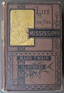
Sold2023Mark Twain, Life on the Mississippi, 1883, 1st Edition, illustrated"Life on the Mississippi" by Mark Twain. Elaborately illustrated throughout with over 300 illustrations, published by James R. Osgood & Co., 1883, First Edition Second State. Tailpiece of Twain in flaSee Sold Price
BonhamsDITTERLINE, THEODORE. 1816-1883. Sketches of the Battles of Gettysburg with Explanatory Map. New...$1,600
Jul 07Worthington GalleriesFirst Edition Hand-colored Map THE NORTH RIDING OF YORKSHIRE by Robert Morden$20
2 days LeftForum AuctionsKnight (E. F.) Where Three Empires Meet, first edition, 1893 & others, military (15)£50
2 days LeftActivity Auctions1799 Campaign of General Buonaparte in Italy Large Map Leather First Edition$500
2 days LeftForum AuctionsTravel.- Barrow (John) An Account of the Travels into the Interior of Southern Africa, first£100
3 days LeftSwann Auction Galleries(AMERICAN REVOLUTION--1779.) Candid and Impartial Narrative of the Transactions of the Fleet, under$750
20 hrs LeftJasper521816 VOYAGE TO ABYSSINIA by HENRY SALT w/ MAP antique 1st AMERICAN EDITION rare$400
2 days LeftForum AuctionsMiddle East.- Thesiger (Wilfred) Arabian Sands, first edition, signed by the author on title, 1959 &£100(1 bid)
3 days LeftA.H. Wilkens Auctions & AppraisalsPOPE. THE ILIAD OF HOMER, FIRST EDITION (1715-20)CA$1,200(1 bid)
5 days LeftTrillium Antique Prints & Rare BooksDe Jode, Rare, pub. 1593 - Frontispiece or Title Page with Map of Germany, Poland and the Low$100
2 days LeftForum AuctionsJefferies (Richard) The Gamekeeper at Home, first edition, original pictorial cloth, gilt, 1878 &£100
BonhamsCELLARIUS, ANDREAS. 1596-1665. Circa Orbem Terrarum Spiralis Revolutio. Amsterdam: J. Jansson, 1...$550(10 bids)
3 days LeftSwann Auction Galleries(HAWAII.) Hiram Bingham. A Residence of Twenty-One Years in the Sandwich Islands.$300
BonhamsTHOREAU, HENRY DAVID. 1817-1862. Walden; Or, Life in the Woods. Boston: Ticknor and Fields, 1854.$4,200(3 bids)


![[Literature] Haggard, H. Rider: King Solomon's Mines (1 of 2)](https://p1.liveauctioneers.com/65/332523/179335141_1_x.jpg?height=282&quality=70&version=1717622830)


