Sold20222 E. Bowen Maps of Italy & GreeceEmanuel Bowen, Welsh, 1694-1767. Two 18th century hand-colored engraved maps. Includes one titled "Middle or Proper Italy" and another titled "A Map of Great Greece and the Islands of Sardinia and CorSee Sold Price
Sold20182 Maps: Stato Del Gran Turco + Asia Minoris.[De Rossi/Middle East] 2 Maps. ++ Stato Del Gran Turco diviso ne suoi Beglierbati, o Governi, e ne Principati, che li sono Tributari. Elaborate map of the Middle East, including Greece, Italy, the CasSee Sold Price
Sold2020Antique Maps by Augustus Mitchell (8)Various maps, including North America, South America, Europe, Italy, Spain, Greece, Brazil. Hand-colored engravings. S. Augustus Mitchell, Philadelphia, c. 1850. 17 1/2" x 14 1/4".See Sold Price
Sold20202 Maps of Greece and MinorcaIncludes Minorca based on a survey of the island with improvements by Emanuel Bowen, engraved for W. Owen at Temple Bar 1756. Overall with frame 12 1/2" wide X 10 3/4" high. Also includes Greece, dateSee Sold Price
Sold20203 European MapsFrench Double Hemisphere G.B. Tardieu, Great Britain Thomas Bowen, Spanish L'Estremadura e la Castigla Nuova. 13-2/4" to 20-2/2" high x 15-3/4" to 20-1/2" wide.See Sold Price
Sold2023[ITALY] Napoli e ContorniGiuseppe M. Galanti; Gatti e Dura Napoli e Contorni (2 Volumes) Napoli: Grimaldi & C. Editori, 2004-2005.Giuseppe M. Galanti: Napoli e Contorni: 25.5cm x 18cm. 17, vii, 381 pages, 1 folding map. IllusSee Sold Price
Sold2017Mitchell: Antique Map of Asia Verso Europe, 1852Map: 1852 Mitchell Map of Asia -- Asia. Verso: western Europe -- France, Italy, Spain, Portugal and Greece. Cartographer: S Mitchell Year / Place: 1852, Philadelphia Dimensions: 8.2 x 10.5 in. ConditiSee Sold Price
Sold2019Two Maps by Johnson & Browning, "Austria, Turkey,Two Maps by Johnson & Browning, "Austria, Turkey, Greece," 1859; together with "Northern and Southern Italy," 1860-1863, hand colored, Italy- H.- 26 1/2 in., W.- 36 in., Austria- H.- 18 in., W.- 26 1/See Sold Price
Sold2018ANTIQUE MAPS - ITALY AND GREECESeries of two antique maps in colors representing the Greece and the Italy.42x55.5cm - 16.5x22" (each)See Sold Price
Sold2020Encyclo. Britannica C1830 Set of 2 Maps of ItalySteel Engraved Map Published 1830-42, Edinburgh for "Encyclopedia Britannica" Seventh Edition. Centre fold as issued. Paper Size: 16 x 11 inch (40 x 28cm) Good conditionSee Sold Price
Sold2019Map of Italy, Greece & Balkans 1725Heading: Author: Seutter, Matthew Title: Theatrum Belli sive Novissima Tabula Qua Maxima pars Danubii et Praeseriim Hungaria... Place Published: Augsburg Publisher: Date Published: 1725 <See Sold Price
Sold2022Antique Map Print - Italy - Greece - Europe - SpainSet of 4 Map Prints. Hand-colored map print of the edition of 1851 from the work Universal Historical and Geographical Atlas ("Atlas Universel Historique et Geographique"). This iconic map contains diSee Sold Price
Sold2023[2] Ceramiche E Mosaici Italy Ceramic Decorated Face Plaques[2] Ceramiche E Mosaici Italy Ceramic Decorated Face Plaques. size: h 9.5 L 11.5 (big) h 9.5 L 7.25 (legs)See Sold Price
Sold2022Antique Map Print - Italy - Empire Greece - EuropeSet of 4 Map Prints. Hand-colored map print of the edition of 1851 from the work Universal Historical and Geographical Atlas ("Atlas Universel Historique et Geographique"). This iconic map contains diSee Sold Price
Sold2020Grp: Maps of Greece and ItalyGroup of ten maps of Italy and Greece. Includes several maps from "Voyage in Italie," including Ravenna, Mantua; "Pianta della Citta di Pisa;" Map of Naples, Paris, 1705. "Cratere Maritimo, o Parte deSee Sold Price
Sold20182 Maps: L’Italia + Italia Antiqua.[De Rossi/Sanson/Italy] 2 Maps. ++ Nicholas Sanson. Italia Antiqua cum Itineribus antiquis. Cum Insulis Sicilia Sardinia & Corsica. Rome: Jo. Jacob. De Rubeis. [C. 1690s.] At lower left: “Joannes L�See Sold Price
Sold20232-map set of N. and S. Italy from 1st ed. of Colton atlasNorthern Italy and Southern Italy along with Corsica, Sardinia and Sicily offered as a 2-map set. “Northern Italy: Lombardy & Venice, Sardinia, Tuscany, Parma, Modena, Lucca and the States of thSee Sold Price
Sold2021(2) Antique Italy Maps, Thomas Kitchin, C. SmithDescription These beautiful maps have both been hand colored and represent Italy. There is one published in London by Charles Smith, possibly early 1800s, framed and discolored from age, but still disSee Sold Price
Sold2023THREE MAPS OF MAINE 19th CenturyTHREE MAPS OF MAINE19th Century1) J.J. Stoner map of Thomaston. Framed 20.25” x 28”.2) E.M. Woodford 1855 rolled map of Thomaston Village. Approx. 47” x 39”.3) Lee & Marsh 1857See Sold Price
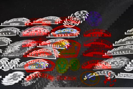
Sold2023Boy Scout International Council PatchesFeaturing Three Transatlantic Council Shoulder Patches 1990's. Together With Seven Red And White Transatlantic Council Shoulder Patches Of Spain, 2 Germany, Italy, Crete, France, Greece And Morocco. ISee Sold Price
Sold2018Johnson's Italy Antique Map (2 map frames), 1861Title/Content of Map: 1861 Johnson's Italy Map (2 map frames) -- Johnson's Northern Italy on sheet with Johnson's Southern Italy Date Printed: 1861, New York Cartographer: Johnson & Browning Size: 24See Sold Price
Sold20212) STIELER & MITCHELL MAPS EUROPE, TURKEY & GREECE(lot of 2) Framed maps, including: (1) engraving with hand coloring on paper, German map of Europe, Turkey, Greece, and the Ionian Islands, from "Stielers Schul-Atlas," published by Justus Perthes, GoSee Sold Price
Sold20222 Framed 18th C. Faden Maps - Greece & Denmark**Originally Listed At $200** Cartographer: William Faden (British, 1749-1836). Engraver: William Palmer (British, 1735-1812). "Graecie Antiquae et Aegaei Maris Tabula" Published by William Faden JanuSee Sold Price
Sold2019Ca 1860's Italy Keith Johnston Maps (2)Two Ca 1860's 'North and Central Italy and the Island of Corsica' and 'South Italy and the Island of Sardinia' Keith Johnston Maps. By Keith Johnston, F.R.S.E. Keith Johnston's General Atlas Engraved,See Sold Price
May 09Hunt and Peck Estate Services, Inc.ANTONIO ZATTA (ITALIAN, 18TH CENTURY) MAP OF VIRGINIA$80(2 bids)
May 09Hunt and Peck Estate Services, Inc.ANTONIO ZATTA (ITALIAN, 18TH CENTURY) MAP OF VIRGINIA$70(1 bid)
Featured3 days LeftJasper521514 PLINY THE YOUNGER F. Regnault POST-INCUNABULA antique NATURAL HISTORY rare$1,900
May 09Hunt and Peck Estate Services, Inc.1694 Alexis-Hubert Jaillot Highly Detailed Map Of Italy$200(1 bid)
May 09Hunt and Peck Estate Services, Inc.After Van de Velde Italian Coastal Scene Oil on Canvas$1,000
May 09Hunt and Peck Estate Services, Inc.Stefano Della Bella "Death Dragging an Old Man To His Tomb"$100
May 09Hunt and Peck Estate Services, Inc.Tobias Conrad Lotter Map Of Eastern Mediterranean & Middle East$100


![2 Maps: Stato Del Gran Turco + Asia Minoris.: [De Rossi/Middle East] 2 Maps. ++ Stato Del Gran Turco diviso ne suoi Beglierbati, o Governi, e ne Principati, che li sono Tributari. Elaborate map of the Middle East, including Greece, Italy, the Cas](https://p1.liveauctioneers.com/179/117971/60557726_1_x.jpg?height=310&quality=70&version=1520636872)


![[ITALY] Napoli e Contorni: Giuseppe M. Galanti; Gatti e Dura Napoli e Contorni (2 Volumes) Napoli: Grimaldi & C. Editori, 2004-2005.Giuseppe M. Galanti: Napoli e Contorni: 25.5cm x 18cm. 17, vii, 381 pages, 1 folding map. Illus](https://p1.liveauctioneers.com/8597/293841/156029746_1_x.jpg?height=310&quality=70&version=1687662564)


![[2] Ceramiche E Mosaici Italy Ceramic Decorated Face Plaques: [2] Ceramiche E Mosaici Italy Ceramic Decorated Face Plaques. size: h 9.5 L 11.5 (big) h 9.5 L 7.25 (legs)](https://p1.liveauctioneers.com/3627/282401/148894678_1_x.jpg?height=310&quality=70&version=1680097885)


![2 Maps: L’Italia + Italia Antiqua.: [De Rossi/Sanson/Italy] 2 Maps. ++ Nicholas Sanson. Italia Antiqua cum Itineribus antiquis. Cum Insulis Sicilia Sardinia & Corsica. Rome: Jo. Jacob. De Rubeis. [C. 1690s.] At lower left: “Joannes L�](https://p1.liveauctioneers.com/179/117971/60557721_1_x.jpg?height=310&quality=70&version=1520636872)