Sold2022AN ANTIQUE PRINTED MAP 'JAPAN' BY A. ARROWSMITH, London 1802. Steel plate Uncoloured. AnAN ANTIQUE PRINTED MAP 'JAPAN' BY A. ARROWSMITH, London 1802. Steel plate Uncoloured. An interesting, clear and detailed map of Japan, excluding Hokkaido but including a blank outline of Korea. The naSee Sold Price
Sold2022AN ANTIQUE PRINTED MAP 'JAPAN INLAND SEA' London C.1870-; Lithograph Original colour. A finelyAN ANTIQUE PRINTED MAP 'JAPAN INLAND SEA' London C.1870-; Lithograph Original colour. A finely produced map of southern Japan, focusing on the area known as The Inland Sea - the waterways between theSee Sold Price
Sold2022ANTIQUE PRINTED MAP BY G. PHILIP COREA AND JAPAN London c. 1859. Lithograph, original Colour. ThisANTIQUE PRINTED MAP BY G. PHILIP COREA AND JAPAN London c. 1859. Lithograph, original Colour. This interesting map of Korea and Japan was published in 'The Philips New General Atlas', George Philip &aSee Sold Price
Sold2022AN ANTIQUE PRINTED MAP BY W. F. MAYERS, London / Hong Kong 1867. MAP OF FOOCHOW. LithographAN ANTIQUE PRINTED MAP BY W. F. MAYERS, London / Hong Kong 1867. MAP OF FOOCHOW. Lithograph uncoloured. William Frederick Mayers was one of a number of British Consular officials active in the major pSee Sold Price
Sold2017Joshua Archer: Antique Map of SyriaJoshua Archer flourished from about 1841-1865. His maps were printed from engraved steel plates. Archer's early work is often overlooked as he is perhaps best recognized for work published in in the CSee Sold Price
Sold2022AN ANTIQUE PRINTED MAP 'DE STADT OSACCO', Leiden 1669- BY A. MONTANUS. Copperplate Uncoloured. AAN ANTIQUE PRINTED MAP 'DE STADT OSACCO', Leiden 1669- BY A. MONTANUS. Copperplate Uncoloured. A fascinating and detailed panoramic view of Osaka in Japan. The city is shown from the sea and a 24 poinSee Sold Price
Sold2022AN ANTIQUE PRINTED MAP BY J. B. DU HALDE / E. BOWEN, London 1738. PROVINCE V. CHE-KYANG;AN ANTIQUE PRINTED MAP BY J. B. DU HALDE / E. BOWEN, London 1738. PROVINCE V. CHE-KYANG; DRAWN ON THE SPOT ... IN THE YEAR 1714. Copperplate Uncoloured. Very detailed map of this Chinese province, froSee Sold Price
Sold2022AN ANTIQUE PRINTED MAP BY LAURENT, Paris c.1780. CARTE DES ISLES KOU RILES DAPRES LE CARTE RUSSE.AN ANTIQUE PRINTED MAP BY LAURENT, Paris c.1780. CARTE DES ISLES KOU RILES DAPRES LE CARTE RUSSE. Copperplate Uncoloured. Detailed and early map showing northern Hokkaido, part of Japan, the adjacentSee Sold Price
Sold2017Arrowsmith: Antique Map of China and Korea, 1823Title/Content of Map: 1823 Arrowsmith Map of China and Korea -- China Date Printed: 1823, London / Edinburgh Cartographer: A Arrowsmith Size: 10 x 8 in. A striking Arrowsmith map, with wonderful colorSee Sold Price
Sold2018Arrowsmith: Antique Map of Pacific Ocean, 1823Title/Content of Map: 1823 Arrowsmith Map of Pacific Ocean -- Pacific Ocean Date Printed: 1823, London / Edinburgh Cartographer: A Arrowsmith Size: 9.8 x 8 in. A striking Arrowsmith map, with wonderfuSee Sold Price
Sold2017Colton: Antique Map of Japan, 1861Map: Japan Date Printed: 1861 Cartographer: J. H. Colton Material/Medium: Paper Size: Approx 17 1/2" x 14 1/4" Condition: Excellent Hand colored, steel engraved. From Colton's General Atlas New York.See Sold Price
Sold20241905 VOYAGE of DISCOVERY VOLS antique ILLUSTRATED British Antarctic explorationSCOTT, Robert Falcon (1868-1912). The Voyage of the ‘Discovery’. London: John Murray, 1905 2 volumes Photogravure frontispieces, 12 color-printed plates, 5 maps (2 folding in rear pocket), numerouSee Sold Price
Sold2019JAPAN. Alcock's route 1861. Inset Nagasaki Harbour.TITLE/CONTENT OF MAP: 'EMPIRE OF JAPAN.; inset Nagasaki harbour; Eastern point of Yeso' DATE PRINTED: 1874 IMAGE SIZE: Approx 41.5 x 34.0cm, 16.5 x 13.25 inches (Large) TYPE: Antique steel engraved maSee Sold Price
Sold2024Europe by Arrowsmith & Lewis 1812 old antique vintage map plan chartTITLE/CONTENT OF MAP: 'Europe' DATE PRINTED: 1812 IMAGE SIZE: Approx 25.0 x 20.0cm, 9.75 x 8 inches (Medium) TYPE: Antique steel engraved map CONDITION: Good; suitable for framing. Please check the scSee Sold Price
Sold2023Sweden and Norway by Arrowsmith & Lewis. Scandinavia & Finland 1812 old mapTITLE/CONTENT OF MAP: 'Sweden and Norway' DATE PRINTED: 1812 IMAGE SIZE: Approx 25.0 x 20.0cm, 9.75 x 8 inches (Medium) TYPE: Antique steel engraved map CONDITION: Good; suitable for framing. Please cSee Sold Price
Sold2018SCOTT, Robert Falcon, Captain (1868-1912). The VoyageSCOTT, Robert Falcon, Captain (1868-1912). The Voyage of the Discovery. London: Smith, Elder, 1905. 2 volumes, royal 8vo (237 x 160 mm). Photogravure frontispieces, 12 color-printed plates, 5 maps (2See Sold Price
Sold2022BOOKS: Nonesuch Dickens - 23 VolumesLondon: the Nonesuch Press, 1937 - 39, edited by Arthur Waugh, Hugh Walpole, Walter Dexter and Thomas Hatton, 23 volumes and a book-form case (titled "Plate"), containing a steel plate entitled "The GSee Sold Price
Sold2022Antique Japanese MapAntique Japanese Map, Marked Ishi-Kawa-Ryugi, Genroku Yonen-Ban-Nippon-zu, Tokyo, Sagamiya, 1691, Maps Of Japan. Folded Approximately 10.375L x 7.0625W in. Unfolded Approximately 66L x 40.25W in.See Sold Price
Sold2017John J. Audubon Trumpeter Swan, Havell ed.John J. Audubon Havell Edition aquatint etching, TRUMPETER SWAN (YOUNG) - CYGNUS BUCCINATOR, plate CCCLXXVI . Printed lower right margin: Engraved, Printed and Coloured by R. Havell 1837. (Published 1See Sold Price
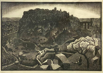
Sold2021M.C. Escher 1925 Italian Period Signed WoodcutVitorchiano nel Cimino original framed woodcut by M.C. Escher (Dutch, 1898-1972). Pencil signed lower left, initialed and dated in plate lower right. Japan paper shows light toning and scattered foxinSee Sold Price
Sold2017Ortelius: Antique Map of the World, 1587Map: World Date Printed: 1587-1612 Cartographer: Abraham Ortelius Material/Medium: Paper Size: *** Approx 16" x 21" Original hand color. Copperplate engraved.One of the most famous and iconic world maSee Sold Price
Sold2021Bowles View of Philadelphia, Heap and ScullRare 1778 Engraved map of Colonial Philadelphia after George Heap (1714-1752) and Nicholas Scull (1687-1761), published by Carington Bowles, London, 1778: AN EAST PERSPECTIVE VIEW OF THE CITY OF PHILASee Sold Price
Sold2023Audubon, John James. Plate CCI Canada Goose Original Elephant Folio Hand Colored EngravingOriginal antique early 19thC Aquatint engraving with original hand coloring. Plate CCI Canada Goose from Birds of America. Engraved by Robert Havell (1793-1878). Published: London, 1827-1838. Sheet siSee Sold Price
Sold2017German 16th Century Style Suit of Armor 67''x26''x17''.German 16th Century Style Suit of Armor 67''x26''x17''. Antique Medieval or Gothic suit of steel armor purchased at Holland & Holland Limited, London in 1987 for 9,500 pounds. Includes a close helmetSee Sold Price
Featured13 hrs LeftJasper52Early 19th Century Antique George III Silver Pair Salt Cellars London 1802 Paul Storr$3,000
May 17Albion AuctionsPaterson & Mogg C1830 British Road Map. Cumberland, Westmorland & Lancashire$5(1 bid)
2 days LeftAlbion AuctionsRees, Abraham 1820 Pair of Architectural Prints. Greece, Athens Parthenon, Pandrosus$5(1 bid)
Featured2 days LeftJasper52JAMAICA & HAITI. 'Hayti'. Caribbean West Indies. WELLER 1863 old antique map$35
2 days LeftWorld of Antiques, Inc.Cartier Must De Ronde in Gold Vermeil over Silver w/Sapphires, Rubies,Tsavorites, Diamonds$2,200
May 15University ArchivesFeb. 1777 Issue of The Gentleman's Magazine with Superb Map of Philadelphia$140(1 bid)
Old Steel Historical Firearms LLCAntique Bowie Knife - 7.5 Inch Blade - Possible Confederate$60(5 bids)
May 16Ma San AuctionCHARLES WILLIAM BARTLETT (1860-1940) Woodblock print on paper of Japan, Tokio Bay From Negishi,£160(1 bid)