Sold2022[ANTIQUE MAPS] BODENEHR MITTELLÄNDISCHE MEER 1725[ANTIQUE MAPS] BODENEHR, GABRIEL. "MITTELLÄNDISCHE MEER" (MEDITERRANEAN SEA) Circa. 1725. Approx. 28X16cm. Frame not included. Map will be removed from frame and securely shipped in cardboard tubeSee Sold Price
Sold20222 Antique Maps of Saltzberg & Swiss AlpsTwo 18th century hand-colored engraved maps. Includes one titled "Saltzberg" by Gabriel Bodenehr and another titled "La Descente du Cote du Midi des Alpes" (The Descent on the South Side of the Alps)See Sold Price
Sold2021Four Antique MapsFour antique maps. Including a very early hand made paper map of Florida and Virginia. Fragment of old newspaper on back dated 1630. Unframed, each approx H 21" W 24". All in excellent condition, minoSee Sold Price
Sold2023TWO ANTIQUE MAPS OF CHINA.Two antique maps of China, including Chinae by Abraham Ortelius, 1595, image 14.25” x 18.25”, with map of Eastern Asia, Le table de la region orientale, image 10” x 13.5”.See Sold Price
Sold2018Morden: Antique Map of Florida & the Great Lakes, 16931693 map of Florida and the Great Lakes by Robert Morden. 5 x 5 inches. A very special map--one of the very earliest obtainable English maps of the American colonies. A Map of Florida and Ye Great LakSee Sold Price
Sold2021Eight Antique Maps by HoefnagelEight Antique Maps by Hoefnagel , 17th c., from Civitates Orbis Terrarum, 5 hand-colored, sheets 16 in. x 20 in Provenance: Property deaccessioned from the Louisiana State Museum, proceeds to be usedSee Sold Price
Sold2021Eleven Antique Maps of EuropeEleven Antique Maps of Europe , 16th-18th c., incl. Ptolemy from 1541 (4); a Blaeu map of "Regno di Napoli", Hondius map of the Holy Land, de Wit map of Southern Spain, an undated manuscript map of MeSee Sold Price
Sold2022John SPEED: Two Antique Maps of IrelandTwo framed antique maps of Ireland by John Speed, a well known English cartographers circa 17th century. [Maps: 15" H x 20" W; Frames: 24" H x 28 1/2" W].See Sold Price
Sold2023Six Antique Maps of America Engravings, 19th c., H.- 7 1/4 in., W.- 4 1/2 in., Framed- H.- 15 in.,Six Antique Maps of America Engravings, 19th c., includes: "Map 8 1776 / Framing Declaration," "Map 5 1692 / New France: Map of the Discoveries of Marquette, La Salle and Other Frenchmen," "Map No. 12See Sold Price
Sold2020AN ANTIQUE MAP, "America," MILAN, CIRCA 1832,AN ANTIQUE MAP, "America," MILAN, CIRCA 1832, hand-colored lithograph on paper, titled "America," above "Dono," and the encyclopedic title, attributed as one of seven folding maps found in the thirtSee Sold Price
Sold20244 Antique Maps of Various LocationsFrench Map of Canada By Guillaume Del'Isle, Map Of Asia By Guiljelmo Blaeuw, Double Hemisphere map By Nicolao Visscher, Map Of The Holy Land Jerusalem, all maps are roughly 18" x 14"See Sold Price
Sold2018Three Antique Mapswith The Countries and Islands Of The South Sea Company, 25 3/4" x 19 3/4" (sight) America Meridio Nalis, 15" x 20" (sight) Hispaniae, Novae Sivae, 14 1/2" x 20" (sight)See Sold Price
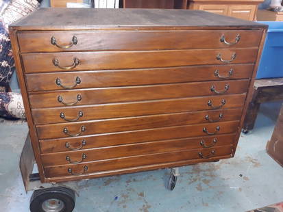
Sold2020Antique Map Architect Blue Print Sea Captain Chest 9 drAntique Map Architect Blue Print Sea Captain Chest 9 drawers custom made flat file cabinet for sea captain architect or blue prints,Maps, 9 drawers all on roller glides drawers work great very good coSee Sold Price
Sold2024Group of 4 Antique MapsIncludes The World in hemispheres, Minnesota, Nebraska and Asiae Nova Descriptiq, Nebraska map measures 14 1/2 x 19 1/2 inchesSee Sold Price
Sold2024Group of 4 1897 Antique MapsIncludes Alabama, Maine, New Jersey and Oregon, Oregon map measures 19 1/4 x 14 1/2 inchesSee Sold Price
Sold2024Group of 4 1880 - 1900s Antique MapsIncludes Alaska, Mississippi, Louisiana and British controlled Canada,See Sold Price
Sold2024Group of 4 The Century Atlas 1890s - 1900s Antique MapsIncludes India, Australia, The Chinese Empire and Quebec, Australia map measures 15 x 19 1/2 inchesSee Sold Price
Sold2017Ortelius: Antique Map of the World, 1587Map: World Date Printed: 1587-1612 Cartographer: Abraham Ortelius Material/Medium: Paper Size: *** Approx 16" x 21" Original hand color. Copperplate engraved.One of the most famous and iconic world maSee Sold Price
Sold2017Levasseur: Antique Map of North America, 1840Title/Content of Map: 1840 Levasseur Map of North America - Amerique Septrentionale Date Printed: 1840 Paris Cartographer: V. Levasseur Size: 11 x 16.5 in. Condition: Excellent. Minor age toning; issuSee Sold Price
Sold2017Jaillot: Antique Map of North America, 1696Map: 1696 Jaillot Map of North America (California as an Island) -- Amerique Septentrionale Divisee en ses Principales Parties Date Printed: 1696 Amsterdam Cartographer: H. Jaillot Size: 19.3 x 23 in.See Sold Price
Sold2018Homann: Antique Map of New England, 1720The map names New England as "Almouchi Cosen" as well as Nova Anglia, while present-day New York State is named variously as New Jork, Nieuw Nederland and Novum Belgium (New York, New Netherlands andSee Sold Price
Sold2024Matthaus Merian 1627 Antique Map Engraving "Virginia" from Theodore de Bry's "Grand Voyages" #1Antique 1627 map of Virginia by Matthaus Merian after John Smith's 1612 map, from Theodore de Bry's "Grand Voyages". Please see "The Philidelphia Print Shop" sheet shown in final photo. Good conditionSee Sold Price
Sold2017Forlani: Antique Map, Town View of Venice, 1569Title: Venetia, Splendid 1569 Lafreri-school town view of Venice Map maker: Paolo Forlani, De’ disegni delle più illustri città et fortezze del mondo Place and Year: Venice, 1569 Dimensions: 19.2See Sold Price
Sold2024John Speed 1676 Original Antique Map of Virginia and Maryland No ColorAntique 1676 map of Virginia and Maryland engraved by Francis Lamb and republished by Thomas Basset & Richard Chriswell after John Speed's 1611 atlas. With "The Description of Mary-Land" text on reverSee Sold Price
Featured3 days LeftJasper52Portrait of Frederick the Wise, after a painting of Albrecht Durer. Heliogravure by Amand Durand.$180
7 days LeftTrillium Antique Prints & Rare BooksBraun & Hogenberg, pub. 1575 - View of Cusco, Peru and Mexico$100(1 bid)
Featured4 days LeftJasper52PACIFIC OCEAN currents British French German US Spanish colonies. LETTS 1889 map$15
Featured3 days LeftJasper52View of Tiber with Triumphal Bridge (Rome, Italy), after Turner. Antique engraving, 1878$100
7 days LeftTrillium Antique Prints & Rare BooksHamilton - Pair of Engravings of a Painting from a Grecian Vase$100
Featured3 days LeftJasper52The Virgin with Child and the monkey - Heliogravure by Amand-Durand, after Albrecht Durer - 19th$200
4 days LeftJasper52Carte de l'Isle de Bourbon, autrefois Mascareigne'. Réunion. BELLIN 1750 map$70(1 bid)
7 days LeftTrillium Antique Prints & Rare BooksGould - Elegant Erythronote Hummingbird (Erythronota Elegans)$100
7 days LeftTrillium Antique Prints & Rare BooksGould - Cora's Shear-tail Hummingbird (Thaumastura Corae)$100
7 days LeftTrillium Antique Prints & Rare BooksHamilton - Pair of Engravings of a Painting from a Grecian Vase$100
7 days LeftTrillium Antique Prints & Rare BooksHamilton - Pair of Engravings of a Painting from a Grecian Vase$100
Featured3 days LeftJasper52Goya etching. Disasters of War, 1937 edition. Plate 58 'It's no use crying out'.$460
Featured3 days LeftJasper521719 BIBLE DUTCH BIBLIA FOLIO w/ CLASPS & MAPS antique decorative binding$800
3 days LeftJasper52c1720 World showing Dutch East India Co possessions. CA as a island. By J.Malherbe$650
3 days LeftJasper521792 ANCIENT HISTORY of INDIA antique ILLUSTRATED w/ MAPS 18th CENTURY in FRENCH$170


![[ANTIQUE MAPS] BODENEHR MITTELLÄNDISCHE MEER 1725: [ANTIQUE MAPS] BODENEHR, GABRIEL. "MITTELLÄNDISCHE MEER" (MEDITERRANEAN SEA) Circa. 1725. Approx. 28X16cm. Frame not included. Map will be removed from frame and securely shipped in cardboard tube](https://p1.liveauctioneers.com/8321/253807/131946555_1_x.jpg?height=310&quality=70&version=1657219252)
![[ANTIQUE MAPS] BODENEHR MITTELLÄNDISCHE MEER 1725 First Image](https://p1.liveauctioneers.com/8321/253807/131946555_1_x.jpg?height=300&quality=1&version=1657219252&width=300)
![[ANTIQUE MAPS] BODENEHR MITTELLÄNDISCHE MEER 1725 First Image](https://p1.liveauctioneers.com/8321/253807/131946555_1_x.jpg?height=300&quality=95&version=1657219252&width=300)


![John SPEED: Two Antique Maps of Ireland: Two framed antique maps of Ireland by John Speed, a well known English cartographers circa 17th century. [Maps: 15" H x 20" W; Frames: 24" H x 28 1/2" W].](https://p1.liveauctioneers.com/1221/264089/138965458_1_x.jpg?height=310&quality=70&version=1667576821)