Sold2020Color maps of Canada, 1880Heading: (Canada) Author: Hurlbert, J. Beaufort Title: Physical Atlas with Coloured Maps, showing...the Dominion of Canada Place Published: [Ottawa] Publisher: Date Published: [1880] DeSee Sold Price
Sold2021Map of Manitoba - CanadaMap of Manitoba - Canada Color Map Dated: 19th century Dimensions: 10 x 6 1/2" Condition Report Good. Text on verso. Subject References:See Sold Price
Sold2020Picturesque Australia Set of 4 BooksThis 4 volume set has beautiful hardbound covers. Titled Picturesque Australia. They are form the 1880's. Color maps, black and white engraved plates. Condition: excellent. call for additional conditiSee Sold Price
Sold2022(PICTORIAL MAPS.) Peter Reynolds Furse. Group of 3 color-printed maps relating to North America.(PICTORIAL MAPS.) Peter Reynolds Furse. Group of 3 color-printed maps relating to North America. Canada, mid-1960s and after - Some of the Explorers of North America. Offset color-printed lithograph,See Sold Price
Sold2023Becker, F. P. C1845 Antique Map. CanadaSteel Engraved Map Published C1845, London for "A Complete and Universal English Dictionary" by the Rev. James Barclay and B. B. Woodward. Maps by F. P. Becker. Outline hand color. Paper Size: 11 x 8See Sold Price
Sold2020Becker, F. C1838 Antique Map. CanadaSteel Engraved Map with outline hand color Published C1838, London for "A Complete and Universal English Dictionary" by the Rev. James Barclay et al. Maps by F. Becker and others. Paper Size: 10.5 x 8See Sold Price
Sold2023MAP, Canada, CruttwellEastern Canada. Clement Cruttwell, British America, Comprehending Canada, Labrador, New-Foundland, Nova Scotia &c:, from Atlas to Cruttwell's Gazetteer, 1808 (dated). Hand Color. This scarce map of CaSee Sold Price
Sold2016Map of the Midwest Grant Trunk Railway of Canada 1880Map: Map of the Chicago, Milwaukee & St. Paul Railway, and its Connections with the Grant Trunk Railway of Canada Maker: Railway News Size: Folio - 15 inches high x 21.1 inches wide Date: 1880 "SuppleSee Sold Price
Sold2017New England & Canada Timetables & Travel FoldersA group of 5 timetables and travel folders: (1) Fitchburg - 3/1/1879 - Hoosac Tunnel 12 panel folder with outstanding color map on one side (2) Dominion Atlantic Railway "Evangeline's Land" - 36 pagesSee Sold Price
Sold2023USBM Map, Kenora Manitoba-Ontario, CanadaA color map showing roads, lakes, and borders of the city of Kenora in Ontario. Publishing stamp by "Department of Mine and Resources" located on top. Issued: 20th Century Dimensions: 30"L x 2See Sold Price
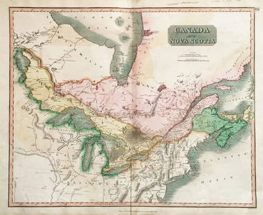
Sold2018Thomson: Antique Map of Canada & Nova Scotia, 1814Map: Canada and Nova Scotia Cartographer: Thomson Place & Date: Edinburgh / 1814/1817 Size: 23 3/4" x 19 1/8" Condition: wash color; light browning and minor staining in margins The superbly detailedSee Sold Price
Sold2018Thomson: Upper & Lower Canada, Nova ScotiaMap: Canada and Nova Scotia Cartographer: Thomson Place/Date: Edinburgh / 1814/1817 Size: 23 3/4" x 19 1/8" Condition: wash color; light browning along centerfold and in margins; some staining in uppeSee Sold Price
Sold20223-Pulvers Highway Maps 2-California-Nevada, Canada to Mexicorated 7, 8"x3.5", all have good color and light wear.See Sold Price
Sold2021Tallis, John (Pub) 1852 Map. West CanadaSteel Engraved Map with Original Outline Hand Color Published 1852-56 by John Tallis, London for "The Universal Pronouncing Dictionary" by Thomas Wright. Drawn & Engraved by John Rapkin. Centre fold aSee Sold Price
Sold2021Tallis, John (Pub) 1852 Map East Canada & New BrunswickSteel Engraved Map with Original Outline Hand Color Published 1852-56 by John Tallis, London for "The Universal Pronouncing Dictionary" by Thomas Wright. Drawn & Engraved by John Rapkin. Centre fold aSee Sold Price
Sold2018Boston & Maine Railroad Timetables & Travel FoldersA group of 3 B&M folders: 1880 timetable (6/28/1880), 1908 resorts travel folder with big color folding map, 1913 timetable with Through schedules. Expect wear and some seam splitting.See Sold Price
Sold2018SDUK United States and Canada“North American Index Map to Canada and the United States.” London: Baldwin & Gradock, 1832. 14 x 12 1/4.. Engraving by J.&C. Walker. Original outline color. Very good condition. Please note thatSee Sold Price
Sold2021Tallis, John (Pub) 1852 Map. British America. CanadaSteel Engraved Map with Original Outline Hand Color Published 1852-56 by John Tallis, London for "The Universal Pronouncing Dictionary" by Thomas Wright. Drawn & Engraved by John Rapkin. Centre fold aSee Sold Price
Sold2019Johnson Map of Eastern CanadaJOHNSON, Alvin Jewitt (1827-1884) & WARD, Benjamin P. (19th Century). Johnson’s New Brunswick, Nova Scotia, Newfoundland and Prince Edward Id. Lithographed map with hand color from the New IlluSee Sold Price
Sold2020Wallace, Alfred Russel (1823-1913) Island Life: or, theWallace, Alfred Russel (1823-1913) Island Life: or, the Phenomena and Causes of Insular Faunas and Floras. London: Macmillan & co., 1880.First edition, octavo, bound with frontispiece map in color, adSee Sold Price
Sold20241875 Rand Avery and Co. Map of Express Companies and Railroads of the USA and CanadaThis is an 1875 Rand Avery and Company Map of Express Companies of the USA and Canada. This map is paper on linen, and express routes are show in different colors, while all railroad lines are labeledSee Sold Price
Sold2017Cary: Antique Map of Upper & Lower Canada, 1807Map: A New Map of Upper & Lower Canada Cartographer: John Cary Place & Date: London / 1807 Size: 20 1/4" x 18" Condition: original color; light overall age toning; a repaired nick in the edge of the uSee Sold Price
Sold2017Tardieu: Antique Map of Northern U.S & Canada, 1798Map: Carte de la Partie Septentrionale des Etats Unis comprenant le Canada Cartographer: Chanlaire & Mentelle / Tardieu Place & Date: Paris / 1798 Size: 16 3/4" x 13" Condition: outline color; mild frSee Sold Price
Sold20171852 CROTONS MAP OF THE UNITED STATES & CANADASCOLTON, J[oseph] H[utchins]. Colton’s Map of the United States & Canadas. Routes are by Railroads, Stage-Roads, and Canals. Lithograph map with original color. Original red cover with gold gilt lettSee Sold Price
4 days LeftJasper521884 Rand McNally Map of US Railroad System -- Map Exhibiting the Several Pacific Railroads Prepared$140
19 hrs LeftTrillium Antique Prints & Rare BooksCarey, pub. 1814 - Map of Hindostan or India$50(1 bid)
19 hrs LeftTrillium Antique Prints & Rare BooksCarey, pub. 1814 - Map of the East Indies with India, China, & New Holland (Australia)$50(1 bid)
19 hrs LeftTrillium Antique Prints & Rare BooksCarey, pub. 1814 - Map of New South Wales, Australia$50


![Color maps of Canada, 1880: Heading: (Canada) Author: Hurlbert, J. Beaufort Title: Physical Atlas with Coloured Maps, showing...the Dominion of Canada Place Published: [Ottawa] Publisher: Date Published: [1880] De](https://p1.liveauctioneers.com/642/160899/81200337_1_x.jpg?height=310&quality=70&version=1580843388)


![1852 CROTONS MAP OF THE UNITED STATES & CANADAS: COLTON, J[oseph] H[utchins]. Colton’s Map of the United States & Canadas. Routes are by Railroads, Stage-Roads, and Canals. Lithograph map with original color. Original red cover with gold gilt lett](https://p1.liveauctioneers.com/4597/97465/50069280_1_x.jpg?height=310&quality=70&version=1482846039)

![[EPHEMERA]. Group of Booklets, Magazines, Postcards, Brochu... (1 of 1)](https://p1.liveauctioneers.com/928/328184/176813372_1_x.jpg?height=282&quality=70&version=1714496988)


