Sold2017Mitchell: Antique County Map of Utah & Nevada, 1870[Utah, Nevada]. N. p: S. Augustus Mitchell, 1870s. The map was drawn and engraved by W. H. Gamble of Philadelphia. Coloured map. Approximately 11-3/4 x 14-/4 inches image area, one sheet, matted. FineSee Sold Price
Sold2019Mitchell: County Map of Utah & NevadaMap Title: County Map of Utah and NevadaCartographer: S. A. Mitchell Place/Date: Philadelphia / 1870 Size: 14" x 11 5/8" Condition: full color; light overall age toning The beautifully detailed and coSee Sold Price
Sold20201876 Mitchell Map of Colorado, Wyoming, Dakotas,Title/Content of Map: 1876 Mitchell Map of Colorado, Wyoming, Dakotas, Nebraska, and Montana -- County Map of Colorado, Wyoming, Dakota, Montana Date: 1876 Philadelphia Cartographer: S Mitchell Size:See Sold Price
Sold20191903 Rand McNally Map of Colorado -- Rand McNally &Title/Content of Map: 1903 Rand McNally Map of Colorado -- Rand McNally & Co's Colorado Date: 1903, Chicago Cartographer: Rand McNally Size: 19 X 25.7 in. A very nice and large county map of Colorado.See Sold Price
Sold2018Mitchell: Antique Map of Utah and Nevada,1870Title/Content of Map: 1870 Mitchell Map of Utah and Nevada -- County Map of Utah and Nevada Date Printed: 1870 Philadelphia Cartographer: S Mitchell Size: 10.6 X 13.5 in. Handsome county map of Utah aSee Sold Price
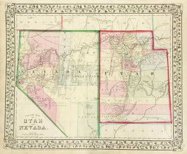
Sold20231877 Mitchell Map of Utah and Nevada [verso] Arizona and New Mexico -- County Map of of Utah andTitle: 1877 Mitchell Map of Utah and Nevada [verso] Arizona and New Mexico -- County Map of of Utah and Nevada [verso] County Map Arizona and New Mexico Cartographer: S Mitchell Year / Place: 1877 PhiSee Sold Price
Sold2019U S Coast Survey 1896 Large Map. Colorado Utah Kansas"Triangulation between Western Kansas and Eastern Utah along or near the 39th Parallel" Large Lithograph Map Published 1896, Washington for "U.S. Coast and Geodetic Survey" Folds as issued. Rare. PapeSee Sold Price
Sold20191876 Mitchell Map of Utah and Nevada [verso] ArizonaTitle/Content of Map: 1876 Mitchell Map of Utah and Nevada [verso] Arizona and New Mexico -- County Map of of Utah and Nevada [verso] County Map Arizona and New Mexico Date: 1876 Philadelphia CartograSee Sold Price
Sold2021Johnson's California Map w/ Territories - Utah,Johnson's California Map w/ Territories - Utah, Colorado, Nevada, etc....21" x 27 1/2"See Sold Price
Sold2022Nevada & Utah 1880Title/Content of Map: Nevada & Utah 1880 Date Printed: 1880 Material/Medium: paper Size: folio, 23x 15 inches Additional Info: Hand colored county & township map of Utah & Nevada by Mitchell. Map measSee Sold Price
Sold2017Colton: Map of California Nevada Utah Colorado ArizonaColton's Map of California, Nevada, Utah, Colorado, Arizona & New Mexico, 1865/1869. Early edition of Colton's map of the Southwestern United States. Unlike in the prior edition, Nevada is no longer tSee Sold Price
Sold20211855 Gunnison Map of Colorado and Utah -- Map No. 4Title: 1855 Gunnison Map of Colorado and Utah -- Map No. 4 From the Coo-Che-To-Pass to the Wahsatch Mountains Under the direction of the Hon. Jefferson Davis… Cartographer: J Gunnison Year / Place:See Sold Price
Sold2024County and Township Map of Utah and NevadaTitle:County and Township Map of Utah and Nevada Publication Date: 1884 Cartographer:WM. M. BRADLEY & BRO. Publisher: MITCHELL, S.A. Height: 13.8 Width: 21.8 Map showing counties separately colored. DSee Sold Price
Sold2022Scarce Johnson map of the Great Western states, 1864Antique map of California, Nevada, Utah, Colorado, New Mexico, and Arizona. Published during a great time of expansion and change in the U.S. West, as well as during the Civil War. Here Utah displaysSee Sold Price
Sold2023Scarce Johnson map of the Great Western states, 1864Authentic vintage map of California, Utah, Nevada, Colorado, New Mexico, and Arizona. Created during a great time of expansion and change in the western United States while the Civil War was still ragSee Sold Price
Sold2022Scarce Hardesty map of Southwest US, 1875Great map of the West, noting copper, silver and gold regions throughout southern Arizona and New Mexico. “Map of Colorado, Utah, New Mexico and Arizona,” by J. David Williams. Published 1875 by HSee Sold Price
Sold2019California Southwest Antique MapEarly map: California, also Utah, Nevada, Colorado, New Mexico and Arizona. Map by A.J. Johnson, New York, c. 1870. 18" x 26 1/2".See Sold Price
Sold2021Gray's Atlas Southwest U.S. Hand-Colored EngravingGray's Atlas, "Map of California, Nevada, Utah, Colorado, Arizona & New Mexico," hand-colored engraving on wove paper, 1873. Image: 16.5" H x 26" W; frame: 26" H x 35.5" WSee Sold Price
Sold20181871 Mitchell Map of Dakotas, Nebraska, Kansas,Title/Content of Map: 1871 Mitchell Map of Dakotas, Nebraska, Kansas, Colorado and Wyoming -- County Map of Dakota, Wyoming, Kansas, Nebraska and Colorado Date: 1871, Philadelphia Cartographer: S MitcSee Sold Price
Sold2022RR map of Colorado from 1888 Cram atlasAuthentic vintage map of Colorado with counties delineated in color by hachures. Shows complete network of railroads during this period. Gives an indication just how fast the state was growing…iSee Sold Price
Sold2018Johnson's California, With Territories of Utah, Nevada,Title/Content of Map: Johnson's California, With Territories of Utah, Nevada, Colorado, New Mexico and Arizona Date Printed: 1864 Cartographer: JOHNSON, A.J. Material/Medium: JOHNSON AND WARD Size: 17See Sold Price
Sold2022Vintage US Travel Destination Maps & BrochuresVintage travel destination magazines, brochures including a map for "The Mountain Empire of the West - Middle Park, Grand County, Colorado" (1934), 1940 maps of Yosemite, Yellowstone National parks asSee Sold Price
Sold2021Guide to Western Ghost TownsA Guide To Western Ghost Towns Includes Alaska, British Columbia, Washington, Oregon, California, Idaho, Nevada, Arizona, Montana, Wyoming, Utah, Colorado, New MSee Sold Price
Sold2020Guide to Western Ghost TownsA Guide To Western Ghost Towns Includes Alaska, British Columbia, Washington, Oregon, California, Idaho, Nevada, Arizona, Montana, Wyoming, Utah, Colorado, New MexicSee Sold Price
2 hrs LeftJasper521865 Colton Map of US Southwest -- Colton's Map of California, Nevada, Utah, Colorado, Arizona & New$160
Jul 02Jasper521894 Smith Map of the Virginias, Maryland and Delaware -- County Map of the States of Delaware,$35
2 days LeftRail & Road AuctionsSeven Chicago Burlington and Quincy / Burlington Travel Brochures and Booklets$20
2 days LeftRail & Road Auctions19 Railroad and Scenic Postcard Folders - Ogden Route, Feather River, Rock Island, Shasta Route,$50
2 days LeftRapid Estate Liquidators and Auction GalleryFramed Collection Engravings & A Map From The Excursions In The County Of Sussex Published In 1822$50


![Mitchell: Antique County Map of Utah & Nevada, 1870: [Utah, Nevada]. N. p: S. Augustus Mitchell, 1870s. The map was drawn and engraved by W. H. Gamble of Philadelphia. Coloured map. Approximately 11-3/4 x 14-/4 inches image area, one sheet, matted. Fine](https://p1.liveauctioneers.com/5584/107399/55057774_1_x.jpg?height=310&quality=70&version=1501794677)


![1877 Mitchell Map of Utah and Nevada [verso] Arizona and New Mexico -- County Map of of Utah and: Title: 1877 Mitchell Map of Utah and Nevada [verso] Arizona and New Mexico -- County Map of of Utah and Nevada [verso] County Map Arizona and New Mexico Cartographer: S Mitchell Year / Place: 1877 Phi](https://p1.liveauctioneers.com/5584/293457/155766077_1_x.jpg?height=310&quality=70&version=1687903812)

![1876 Mitchell Map of Utah and Nevada [verso] Arizona: Title/Content of Map: 1876 Mitchell Map of Utah and Nevada [verso] Arizona and New Mexico -- County Map of of Utah and Nevada [verso] County Map Arizona and New Mexico Date: 1876 Philadelphia Cartogra](https://p1.liveauctioneers.com/5584/137769/69881187_1_x.jpg?height=310&quality=70&version=1552435690)


![1891 Rand McNally Oregon [verso] Nevada -- Oregon [verso] Nevada (1 of 2)](https://p1.liveauctioneers.com/5584/334149/180556642_1_x.jpg?height=282&quality=70&version=1719349709)


