Sold2023North Pole, 'Polkarte'; Frederik De Wit (1610-1698) - "Poli Arctici, et circumiacentium terrarumArtis/Title: North Pole, 'Polkarte'; Frederik De Wit (1610-1698) - "Poli Arctici, et circumiacentium terrarum descriptio novissima" - 1661-1680 Date: 1670 Material: Paper Dimensions: 62 cm x 67 cm DesSee Sold Price
Sold2024EARLY 18TH C. DUTCH CHART OF PACIFIC OCEAN BY FREDERIK DE WIT (1629-1706) WITH CALIFORNIA AS AN"Magnuum Mare del Zur, cum Insula California, De Groote Zuyd-Zee en't Eylandt California; Gedruck't Amsterdam by Frederick De Wit ince Calver Street". Handcolored copper engraving. Engraver: Romeyn deSee Sold Price
Sold20221680 deWit Map of Asia -- Accuratissima Totius AsiaeTitle: 1680 deWit Map of Asia -- Accuratissima Totius Asiae Tabula Recens Emendata Cartographer: F de Wit Year / Place: 1680 c. Amsterdam Map Dimension (in.): 19.3 X 22.9 in. This is a lovely large maSee Sold Price
Sold2023[MAP] DE WIT, F. NOVA ORBIS TABULA IN LUCEM EDITAde Wit, Frederik. NOVA ORBIS TABULA, IN LUCEM EDITA. (Amsterdam: circa 1670s.) Beautiful map in exquisite full handcolouring, with elaborate corner scenes illustrating the four seasons and the Zodiac,See Sold Price
Sold2017WIT, Frederick de (1630-1706). [Composite Atlas].WIT, Frederick de (1630-1706). [Composite Atlas]. Amsterdam: F. de Wit, [n.d. ma circa 1680]. Bellissimo atlante composito con oltre 117 mappe di cui la maggior parte a doppia pagina e colorate all'epSee Sold Price
Sold2022MAP, Middle East, WitMiddle East. Frederick de Wit, Nova Persiae Armeniae Natoliae et Arabiae, 1680 (circa). Hand Color. This splendid map of the Middle East covers the region from Turkey and Egypt to Afghanistan with theSee Sold Price
Sold2017(MAP, SICILY) DE WIT, FREDERICK. Insula sive regnumMAP, SICILY by DE WIT, FREDERICK, Insula sive regnum Siciliae urbibus praecipuis exornatum. Amsterdam, circa 1680. Hand-colored engraved map of Sicily. With inset plans of Messina, Milazzo and PalermoSee Sold Price
Sold2022MAP, South America, WitNorthwestern South America & Central America. Frederick de Wit, Novae Hispaniae, Chili, Peruviae, et Guatimalae Littorae, from Orbis Maritimus ofte Zee Atlas, 1680 (circa). Hand Color. This handsome sSee Sold Price
Sold2022Le Roy und Thomas de Leu, Henri Imagines Septem Planetarum. Folge von 1 gestochenen Titel und 7Astronomie Le Roy und Thomas de Leu, Henri Imagines Septem Planetarum. Folge von 1 gestochenen Titel und 7 Kupfertafeln. Um 1610. Plattenmaße je ca. 18,5 x 12 cm. Knapp auf die Plattenkante beschSee Sold Price
Sold2021Mauritz Frederik De Haas Oil, Rocky CoastMauritz Frederik De Haas (Dutch/American 1832-1895) Rocky Coast with Figures Along the Rocks and Sails at Sea, oil on canvas, signed M.F.H.De Haas, N.A. lower right, framed in 19thc. frame under glassSee Sold Price
Sold2017De Wit Portolan Sea Chart of EuropeTotius Europae Victoria... Frederic De Wit (1630-1706). Engraved map with original hand color. Amsterdam, 1675. 20 x 35 1/2 inches sheet, 27 1/2 x 43 inches framed. “The most striking and decorativeSee Sold Price
Sold2022De Wit - Nova Orbis Tabula In Lucem Edita, MapFrederick De Wit (circa 1629-1706), Nova Orbis Tabula In Lucem Edita, A.F. De Wit, published by Covens and Mortier, Amsterdam, circa 1720, in two sheets, engraving on laid paper, double hemisphere vieSee Sold Price
Sold2022De Wit, Map of North and South America, c. 1720Property of a Private Collector, Hilton Head Island, SC Description: Frederick De Wit (circa 1629-1706), Nova Orbis Tabula In Lucem Edita, A.F. De Wit, Amsterdam: Covens and Mortier, c. 1720, publSee Sold Price
Sold2017de Wit: Map of Southeast Asia, 1670Map: Tabula Indiae Orientalis Cartographer: Frederick De Wit Place & Date: Amsterdam / 1670 Size: 22 1/4" x 18 1/4" Condition: light overall age-toning A highly decorative and beautifully colored lateSee Sold Price
Sold2016An important map of Asia, c1680 by Frederick De WitAn important map of Asia, c1680 by Frederick De Wit depicting the area of Asia, including China, Japan, Tibet, India, Russia, Persia, Arab and more (center folding area repair), 19.5"x23"See Sold Price
Sold2019De Wit Map of HungaryDE WIT, Frederick (1630-1706). Regni Hungariae, et Regionum, quae ei Quondam Fuere Unitae, ut Transilvaniae, Valachiae, Moldaviae, Serviae, Romaniae, Bulgariae, Bessarabiae, Croatiae, Bosniae, DalmatiSee Sold Price
Sold2017De Wit Map of AfricaTotius Africa Accuratissima Tabula. Frederick de Wit (1629/1630-1706). Engraved map with original hand color. Amsterdam, c. 1660. 19 1/4 x 23 inches visible, 24 3/4 x 28 1/2 inches framedSee Sold Price
Sold2020De Wit Map of Africa ca. 1685Frederick de Wit (ca. 1630 – 1706), "Totius Africae Accuratissima Tabula," Amsterdam, ca. 1685. Hand colored map of Africa. African animals are included throughout the continent, and the decoraSee Sold Price
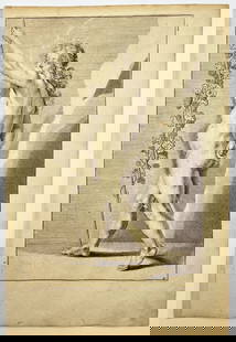
Sold2023Antique Engraving - Frederick de Wit - Female Form - Drawing of Woman FigureTitle/Artist: Antique Engraving - Frederick de Wit - Female Form - Drawing of Woman Figure Medium: Antique engraving originates from "Lumen Picturae: A Classical Drawing Manual" by Frederick de Wit. TSee Sold Price
Sold2018Allard Engraved Map of Iberian PeninsulaCorona Portugalliae cum ei affinibus Regnis Hispanicis...Carel Allard (1648-c. 1709). Engraved map with fine original hand color in full. Amsterdam: Frederick De Wit, c. 1705. In 4 parts, 21 1/8 x 24See Sold Price
Sold2015Magnum Mare del Zur cum InsulaCalifornia by Frederick de Wit (1630-1706), Amsterdam, 1675, copper-engraved mariner's chart, hand-colored in outline, showing California as an island, Tooley #40, with a colorful pictorial cartoucheSee Sold Price
Sold2015Tabula Indiae Orientalis byFrederick de Wit Amsterdam, 1662, de Wit's attractive hand-colored map of Southeast Asia, engraved by Joannas Lhulier, this map served as a prototype for Speed's map of the East Indies, cartouche withSee Sold Price
Sold2018Double page engraved map, Insula Malta AccuratissimeDouble page engraved map, Insula Malta Accuratissime Delineata Urbibus et Fortalitus Malta Frederico de wit Amstelodami, sight size 12" x 24". Provenance: Property from the Credit Suisse Americana ColSee Sold Price
Sold2022HOCHBEDEUTENDE PENDULE Ã LA TORTUEHOCHBEDEUTENDE PENDULE ? LA TORTUE Frankreich, Paris, wohl Entwurf von Emile-Auguste Reiber fuer 'La maison l' Escalier de Cristal', um 1870/ 1880 Bronze, vergoldet, Cloisonne-Emaille. H. 85 cm, B. 40See Sold Price
Jun 13Swann Auction Galleries(LEO BELGICUS.) Claes Janszoon Visscher; after Hessel Gerritsz. Nova XVII Provinciarum, Germaniae$7,500
BonhamsBLAEU (JAN) Delfi Batavorum vernacule Delft, [Amsterdam, 1649 or later]; BLAEU (WILLEM) Novus X...£10
BonhamsEAST AFRICA DE WIT (FREDERICK) Occidentalior Tractus Indiarum Orientalium a Promontorio Bonae Sp...£300
BonhamsAFRICA DE WIT (FREDERICK) Totius Africae Accuratissima Tabula,Amsterdam, Frederick de Wit, [c.16...£60(4 bids)
Jun 13Swann Auction Galleries(ITALY.) Frederick de Wit. Novissima et Accuratissima Totius Italiae Corsicae et Sardiniae.$225
2 days LeftAustin Auction Gallery(2) JOHN DE WIT (20TH C.) ORIENT & FLUME ART GLASS SPIRAL PAPERWEIGHT VASES$150
BonhamsWEST AFRICA DE WIT (FREDERICK) Tractus Littorales Guineae a Promontorio Verde usque ad Sinum Cat...£10(1 bid)
Jun 13Swann Auction Galleries(FLORENCE.) Wenceslaus Hollar; and Frederick de Wit. Florentia Pulcherrima Etruriae Civitas.$750
2 days LeftSubastas de Barcelona S.L. (Subarna Casa de Subastas)18TH CENTURY RUSSIAN SCHOOL. ICON OF OUR LADY OF SMOLENSK, CIRCA 1720.€2,000(3 bids)


![[MAP] DE WIT, F. NOVA ORBIS TABULA IN LUCEM EDITA: de Wit, Frederik. NOVA ORBIS TABULA, IN LUCEM EDITA. (Amsterdam: circa 1670s.) Beautiful map in exquisite full handcolouring, with elaborate corner scenes illustrating the four seasons and the Zodiac,](https://p1.liveauctioneers.com/8124/310027/165853624_1_x.jpg?height=310&quality=70&version=1700184289)
![WIT, Frederick de (1630-1706). [Composite Atlas].: WIT, Frederick de (1630-1706). [Composite Atlas]. Amsterdam: F. de Wit, [n.d. ma circa 1680]. Bellissimo atlante composito con oltre 117 mappe di cui la maggior parte a doppia pagina e colorate all'ep](https://p1.liveauctioneers.com/3662/102842/52581030_1_x.jpg?height=310&quality=70&version=1492593376)


![BLAEU (JAN) Delfi Batavorum vernacule Delft, [Amsterdam, 1649 or later]; BLAEU (WILLEM) Novus X... (1 of 9)](https://p1.liveauctioneers.com/1043/319451/178359083_1_x.jpg?height=282&quality=70&version=1717515630)


