Sold2022From the London Magazine, Three 18th Century Maps: A New Chart of the Rover St. Lawrence from theFrom the London Magazine, Three 18th Century Maps: A New Chart of the Rover St. Lawrence from the Island of Anticosti...; A Plan of the River St. Lawrence from the Falls of Montmorenci to Sillery...;See Sold Price
Sold2022(COLONIAL NORTH AMERICA.) Group of 3 small format 18th-century engraved maps.(COLONIAL NORTH AMERICA.) Group of 3 small format 18th-century engraved maps. London, vd - The Royal Magazine; G. Rollos, engraver. A New and Accurate Map of the Present Seat of War in North America.See Sold Price
Sold2022Three 18th Century North Carolina Mapsengravings on laid paper, all unframed, including: John Reid, The State of North Carolina From the Best Authorities, engraver Benjamin Tanner, New York, circa 1796, sheet 16-1/2 x 19 in.; Matthew CareSee Sold Price
Sold2023Three Framed Items Related to AlaskaA portrait of an Inuit woman by Julie Eaton, an etching titled, "Leela Skinning seals", pencil signed illegibly and numbered 3/100 and an 18th century chart map titled, "Chart of the Norton Sound andSee Sold Price
Sold2017Six 18th and Early 19th Century Nautical Mapsall shrink-wrapped behind mats, titled as follows: Harbour on the Coast of Chili (1770); Port of Permambuco (1816); Chart of New Zealand (1817); Chart of the Intertropical & West Coasts of AustraliaSee Sold Price
Sold2024A New and Correct Sea-Chart of the Western and Southern Ocean, 18thCEdmund Halley, London, 18th century. Lower right: This CHART is Sold by J. Mount, T. Page, and W. Mount, on Tower-hill. With splits and losses. Overall size appx. 24" x 29".See Sold Price
Sold2017Jefferys' 18th Century Map of the Banks of NewfoundlandA chart of the Banks of Newfoundland... Drawn from Chabert, Cook and Flerieu...Thomas Jefferys (c. 1719 – 1771). Copperplate engraved map handcolored in outline. London: Sayer & Bennett, March, 1775See Sold Price
Sold2021[MAPS] A COLLECTION OF MAPS SOLD TOGETHER[MAPS] A collection of maps sold together, including: Bell, A. A NEW CHART OF THE RIVER ST. LAWRENCEFROM THE ISLAND OF ANTICOSTI TO LAKE ONTARIO. London: R. Baldwin, [1759]. Engraved map, 18 x 25 cm.See Sold Price
Sold2023John Senex, "The Kingdom of China"Hand colored 18th century map "newly augmented" by British cartographer John Senex (1678 - 1740). Originally sold by London merchants Thomas Bassett in Fleet Street and Richard Chiswell in St. Paul'sSee Sold Price
Sold2023A Map of New England by Mr. Dezoteux, French Army 1787France, 18th century. A map on laid paper titled 'Chart for the Journal of Mr. le Marquis. de Chastellux' by Mr. Dezoteux, a staff officer of the French Army. Good condition; sealed under a mSee Sold Price
Sold2017Bellin/Jefferys: Antique Map of Canada & Islands, 1746Map: A new chart of the coast of New England, Nova Scotia, New France or Canada, with the islands of Newfoundl’d. Cape Breton, St. John’s &c. Publication Date: 1746 Authors: Gentleman’s MagazineSee Sold Price
Sold202218th C. John Senex Map of India and ChinaJohn Senex map, London, 1721, "A New Map of India & China", outlining the area, and including Japan, Malay Peninsula and Southeast Asia, unframed. [Sheet: 21 1/4" H x 25" W]. In distressed condition,See Sold Price
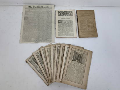
Sold202112 18th Century Magazines and NewspapersIncludes The London Chronicle from October 23, 1777, The Columbian Magazine from January 1789, 9 The Gentleman's Magazine: St. John's Gate dated December 1753, August 1755, June 1755 (2), March 1755,See Sold Price
Sold2021Bellin, Jacques 1746 Map of Canada & New England"A New Chart of the Coast of New England, Nova Scotia, New France or Canada, with the islands of Newfoundld. Cape Breton St. John's &c" by Jacques-Nicolas Bellin. Copper Engraved Map Published LondonSee Sold Price
Sold2017Ten European Hand-Colored Botanical EngravingsSuite of Ten British and French Hand-Colored Botanical Engravings fourth quarter 18th century and first quarter 19th century, including three from Botanical Magazine by William Curtis (British, 1746-1See Sold Price
Sold20217 18th Century Newspapers & MagazinesIncludes Gentleman’s Magazine; St. John’s Gate November 1752, The General Advertiser from Tuesday, January 21, 1794, The Gloucester Journal from April 16, 1854, The London Chronicle fromSee Sold Price
Sold201818th C. Mezzotint Paulo PurgantPaulo Purganti and his Wife from Priors Poems. Printed for and sold by Carington Bowles at his Map and Print Warehouse #69 St. Paul's Church Yard, London. Framed. 13"H. x 9.75"W.See Sold Price
Sold202218th c. Folio King James Bible, IllustratedTHE CHRISTIAN'S NEW AND COMPLETE BRITISH FAMILY BIBLE. London: for Hogg, n.d. (circa 1795.) 15" x 9". With 80 engraved plates (of?), including a few maps/plans. 4 page list of subscribers at end. BounSee Sold Price
Sold20241774 Gentleman's Magazine Boston Tea PartyThe Gentleman's Magazine for January 1774, printed at London by Sylvanus Urban. 48 pages. Three engravings including folding map of route of voyages, one of antiquities, and another of a New Zealand nSee Sold Price
Sold202218TH C. MAP OF NEW ENGLAND"Map of the Northern or New England States of America, Comprehending Vermont, New Hampshire, District of Main (sic), Massachusetts, Rhode Island and Connecticut" by J. Russell. Extends south to includSee Sold Price
Sold202018th c. Map of America- Emanuel Bowen18th c. Map- ''A New and Accurate Map of America''- engraved map, 1748, from John Harris- ''Complete Collection of Voyages and Travels'', short repaired separation at top of centerfold. 14 3/8 x 17 5/See Sold Price
Sold202216th / 18th C. European Maps of New Spain (2)**Originally Listed At $300** Cartographer: Gerard Mercator. "Hispaniae Novae Nova Descriptio" Published by I.E. Cloppenburgh, Amsterdam, 1632. AND Stieler's "Mexico Und Centro-America …" Gotha, 182See Sold Price
Sold2017EPHEMERASixteen pieces including ten 18th c. maps and moon charts of Africa, British America (Canada), South America, West Canada, Mexico, California and Texas, England, Finland, Bothnia, Aberdeen Shire, PolaSee Sold Price
Sold2016Three 18th C London Sterling Silver CastersThree 18th C London Sterling Silver Casters; one being Hester Bateman 1780, one being Thomas Daniel 1774, one being attributed to William and John Deane; three together weighing 8.5 ozt; attributed caSee Sold Price
May 15University ArchivesLate 18th C. Rev. War Engraving, "The American General Lee taken Prisoner" from "Barnard's History"$140
May 06Winter Associates High Chest or Highboy, 18th C, New England, top and base by association, Queen Anne flat top high$450(1 bid)
4 days LeftMerrill's Auctioneers and AppraisersAssembled set of four 18th c New England bannister back chairs$150
May 10New England Auctions - Fred GiampietroThree Large 18th C Hand-Carved Belgian Bluestone Pot au Feu (Flame) Finials$1,000(1 bid)
May 10New England Auctions - Fred GiampietroLarge Curved Segment from an 18th C French Granite Cider Mill$100(1 bid)
BonhamsA GREEN OVERLAY GLASS 'THREE FRIENDS OF WINTER' SNUFF BOTTLE Kangxi three-character mark, 18th c...£700
May 10New England Auctions - Fred Giampietro18th c Wrought Iron French Torchiere Lighting Fixture$75(2 bids)


![[MAPS] A COLLECTION OF MAPS SOLD TOGETHER: [MAPS] A collection of maps sold together, including: Bell, A. A NEW CHART OF THE RIVER ST. LAWRENCEFROM THE ISLAND OF ANTICOSTI TO LAKE ONTARIO. London: R. Baldwin, [1759]. Engraved map, 18 x 25 cm.](https://p1.liveauctioneers.com/1124/208511/106199202_1_x.jpg?height=310&quality=70&version=1624388585)


![18th C. John Senex Map of India and China: John Senex map, London, 1721, "A New Map of India & China", outlining the area, and including Japan, Malay Peninsula and Southeast Asia, unframed. [Sheet: 21 1/4" H x 25" W]. In distressed condition,](https://p1.liveauctioneers.com/1221/258471/135401029_1_x.jpg?height=310&quality=70&version=1661963765)