Sold2015GEN. ROBERT C. RICHARDSON'S MAPS AND NOTES FROM FRENCHGEN. ROBERT C. RICHARDSON'S MAPS AND NOTES FROM FRENCH MILITARY SCHOOL ROBERT C. RICHARDSON, JR. (1882-1954) American Army general, Commanding General of the Hawaiian Department, Military Governor ofSee Sold Price
Sold2020Life Aboard a British PrivateerIn the time of Queen Anne. First edition. With notes, illustrations, and a map by Robert C. Leslie. Publishers decorative blue cloth with gilt title to spine Fold-out map with tissue-guard. 9 full-pagSee Sold Price
Sold20164 Maps: 1760 N. Am.; Botanic Geo.; Eur.; OK Terr.Four Antique Maps; a French 1760 Map of North American ''AMÉRIQUE SEPTENTRIONALE...1750'' Paris: S. Robert De Vaugondy, c. 1750 (1st edition, dated in the cartouche; "Outlines of Botanical Geography"See Sold Price
Sold2021ROBERT DE VAUGONDY, MAP OF CARIBBEAN, C. 1780Robert de Vaugondy (French, 1686-1766). "Partie de la Mer du Nord...." -circa 1780, engraving with hand coloring. Approx. 21" x 25.75" (sheet)See Sold Price
Sold2021ROBERT DE VAUGONDY MAP OF SOUTH AMERICA, C. 1750Robert de Vaugondy (French, 1686-1766). "Amerique Meridionale" -1750, engraving with hand coloring. Approx. 20" x 24.75' (sheet)See Sold Price
Sold2017Gilles Robert De Vaugondy, map of EnglandGilles Robert De Vaugondy, map of England, Gilles Robert De Vaugondy (French, 1688-1766), "Le Royaume D'Angleterre", c. 1753, hand-colored map of the Kingdom of England, divided into the seven ancientSee Sold Price
Sold2019French Gilt and Enameled Opaline Glass VaseFrench Gilt and Enameled Opaline Glass Vase, 19th c., attr. to Jean Francois-Robert, Baccarat, polychrome floral decoration, applied mask handles, h. 19 1/4 in., Note: base drilledSee Sold Price
Sold2024Europe exhibiting its principal states &c. First French Empire. FADEN 1791 mapTITLE/CONTENT OF MAP: 'Europe exhibiting its principal states &c' DATE PRINTED: 1791 IMAGE SIZE: Approx 54.5 x 69.5cm, 21.5 x 27.25 inches (Large); Please note that this is a folding map. TYPE: LargeSee Sold Price
Sold2020FRENCH 18TH C. CARVED OAK DOUBLE DOOR VITRINEHeight- 88" Width- 65" Depth- 22" Note- Must be picked up in Monterey location 5 days after saleSee Sold Price
Sold2020FRENCH 19TH C. MARBLE MANTLE CLOCKHeight- 18" Width- 20"Please note: The auction house does not guarantee any of the clocks and watches are running or functioning properly.See Sold Price
Sold202319th C. Oil on Canvas of Gen. Archibald Gracie III19th century note to reverse includes "Painted on the battlefield by one of his adoring artist soldiers - roommate at west point academy of General Robert E. Lee...". Gracie was president of the BankSee Sold Price
Sold2023WWII Army Uniform of General Robert Richardson Commander Pacific ForcesOriginal 1943 dated Regulation Army winter uniform jacket owned and worn by Lieutenant General Robert C. Richardson during his service in Hawaii as Commander of Army Forces in the Pacific and MilitarySee Sold Price
Sold2019Archive including U.S. Army General Robert C.Militaria Archive including U.S. Army General Robert C. Richardson III's Defense Superior Service Medal in presentation case, and other award ribbons including his Legion of Merit Service Ribbon, WorlSee Sold Price
Sold2021Pair 18th C French Maps after the AntiqueTo include "A View of the Town-House or Guild Hall of Paris" and "Vue de Chateau Royal D'amboise" : mid 20th century prints after the antique, housed in concave giltwood frames. Copperplate engravingsSee Sold Price
Sold201718th C. French Map w/ Oiled Paper, ex-Sotheby'sEurope, France, map from 1709 CE, oiled paper overlays from 1756 to 1763 CE, owned by Louis-Alexandre Berthier (1753 to 1815 CE), Marshal, Vice-Constable of France, and Chief of Staff (Major general)See Sold Price
Sold202118th C. French Map "Le Noveau Mexique …"Ribobert Bonne (French, 1727-1794). "Le Nouveau Mexique, Avec La Partie Septentrionale De L'Ancien, ou De La Nouvelle Espagne" Published in Paris, 1780. Among the most collected late 18th century mapsSee Sold Price
Sold2018Framed 18th C. French Map of Ancient Rome**First Time At Auction** Louis Brion de la Tour (French, 1743-1810) & Louis Charles Desnos (French, 1725-1805), "Suite De L'Histoire De Rome", ca. 1760 to 1770. Copperplate engraved with original hanSee Sold Price
Sold201919th C. French Map - The Port of Vera Cruz Mexico100% of the Hammer price of all lots sold in this auction will be donated to Community Food Share by Artemis Gallery. $1.00 = 3 meals! **First Time At Auction** Europe, France, ca. 19th century CE.See Sold Price
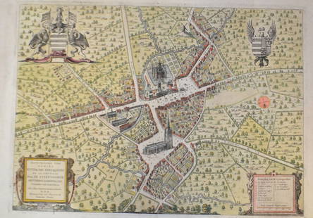
Sold201518th C French Map Of SteenvoordePLOUICH, Vedastus du -" Illvstrissimo viro domino" .The city of Steenvoorde is a small town located north of France. The city of Steenvoorde is located in the department of Nord of the french region.See Sold Price
Sold2018ROBERT, Vintage Oil/c French Street Scene Outdoor CafeROBERT, Vintage Oil/c French Street Scene Outdoor Cafe, signed, original frame, oil painting on canvas. Size: 24 x 48 , outside of frame: 28 x 52See Sold Price
Sold2017Antique 19th C French Hand Colored Map of CalvadosAntique 19th C map of the French area of Calvados. This area of France is known for its production of Calvados. The engraving is surrounded by scenes showing the region and its products. Published bySee Sold Price
Sold2022c. 1788 French Map of the Eastern United StatesHistoric Maps c. 1788 Map, "Les Etats Unis de L'Amerique Septentrionale, Partie Orientale" (Eastern Part of the Northern United States of America) by M. (Rigobert) Bonne c. 1788 Map titled, "Les EtatsSee Sold Price
3 days LeftHeritage Auctions55026: Robert Wander Black Onyx, Diamond, Gold Earring$4,000
4 days LeftJasper521753 Robert de Vaugondy Map of Central France -- Gouvernemens Generaux De La Marche, Du Limosin Et$45
May 14Fleischer's AuctionsGen. Sherman's Annotated "Sherman and His Campaigns: A Military Biography"$250(1 bid)
Jun 02Taylor & Harris12 + 1 Robert Haviland Limoges France Porcelain Tea Cups and Saucers c. 1930$180
May 19The Heritage Gallery at Sayville Antiques, IncEarly 20th c. Gustave Madelain O/C Le Havre Harbor France$60(2 bids)


![[Civil War] General Lee’s Surrendered Funds (1 of 2)](https://p1.liveauctioneers.com/7226/325455/175169110_1_x.jpg?height=282&quality=70&version=1712370394)


